
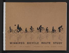
- i04800
- Item
- Apr. 1973
Part of The W.R.E.N.C.H. Winnipeg Cycling Archive collection
Winnipeg (Man.)
351 results with digital objects Show results with digital objects
Part of The W.R.E.N.C.H. Winnipeg Cycling Archive collection
Winnipeg (Man.)

Footbridge in La Barriere Park
Photograph of a footbridge across the La Salle River in La Barriere Park. A description of the photo used for publication is recorded on a separate piece of paper. Photo's reverse is stamped by the Parks and Protection Division of the Metro Government.
Metropolitan Corporation of Greater Winnipeg (Man.). Information Officer
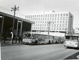
Buses picking up passengers outside City Hall
Photograph of several buses in front of City Hall. One, bound for Portage Avenue and Polo Park, is picking up passengers. The photo is marked "One-way Street" and includes a cut line that reads "...gave way to the new". On the photo's reverse, the make and model of the bus is detailed as follows: Make - GMC, Model - TDH 5301, Year - 1960, Seat Capacity - 51. Photographer is unknown.
Metropolitan Corporation of Greater Winnipeg (Man.). Information Officer

Trolley bus bound for Corydon Avenue in front of the Legislature Building
A photograph of a trolley bus in front of the Manitoba Legislature Building. The bus signs indicate it is bound for Corydon Avenue. According to handwritten text on the photo's reverse, the bus was made by Canada Car in 1948, has a 249 inch wheel base and can seat 44 passangers. The photo is also marked "Metro Transit Publicity". The photographer is unknown.
Metropolitan Corporation of Greater Winnipeg (Man.). Information Officer
Photographs of overpasses and areas of the Greater Winnipeg Area for which overpasses were proposed.
Metropolitan Corporation of Greater Winnipeg (Man.). Information Officer
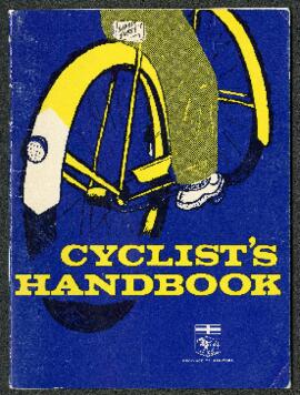
Cyclist’s Handbook, Province of Manitoba
Part of The W.R.E.N.C.H. Winnipeg Cycling Archive collection
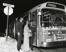
Chartered bus - "Wedding Special"
Photograph of a newly married couple posing with a bus driver in front of a bus parked on Academy Road. The bus has been chartered and is decorated with a sign that says "Wedding Special" on the front. Unknown photographer.
Metropolitan Corporation of Greater Winnipeg (Man.). Information Officer
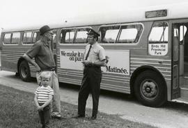
Bus driver in front of Birds Hill Provincial Park bus
Photograph of the first transit bus in service to Birds Hill Provincial Park. In front of the bus are J. A. (Tony) Painchaud, Assistant Superintendent of Transporation and his grandson (left), and bus driver Art Dupas (right).
Metropolitan Corporation of Greater Winnipeg (Man.). Information Officer
Photographs of buildings on Portage Avenue including the Bank of Montreal, Zeller's, the Power Building, Winnipeg Electric Co. and the Royal Bank Building.
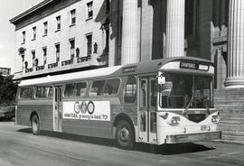
First Western Flyer bus in front of Legislature
Photograph of the first Western Flyer bus used in Winnipeg, parked in front of the Manitoba Legislature Building. The bus is chartered and bears an advertisement on its side for Manitoba's centennial. Publishing information is on the reverse. Unknown photographer.
Metropolitan Corporation of Greater Winnipeg (Man.). Information Officer
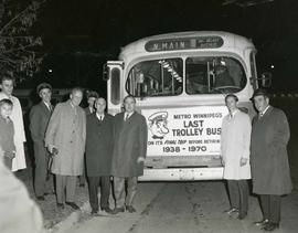
Winnipeg's last trolley bus at the Carruthers Avenue Garage
Photograph of the last trolley bus operated in Winnipeg. The bus was on route to north Main Street and McAdam Avenue, and bears the face of transit's "Transit Tom" mascot, as well as text advertising it as the last trolley bus. Left to right are Transit Division employees Don Morrison (Special Projects Officer), Robert M. Simister (Superintendent, Electrical Distribution Branch), Walter Marshal, J. A. (Tony) Painchaud (Assistant Superintendent of Transportation Operation), Roy W. Church (Manager of Transit Operations), Robert G. Ferguson (Superintendent of Schedules), and C. E. ("Ed") LaForme (Superintendent of Transportation). Information about the photograph is written on attached scrap paper. The photographer is unknown.
Metropolitan Corporation of Greater Winnipeg (Man.). Information Officer
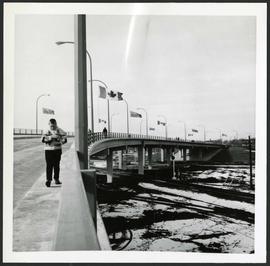
People walking across overpass
Photograph of people walking across the Nairn Overpass with snow on the ground below. The overpass is lined with flags. Photographed by Gunter A. Schoch, Landscape Architect for the Metro Parks and Protection Division.
Metropolitan Corporation of Greater Winnipeg (Man.). Information Officer

Dakota Village Shopping Centre panorama
View of Dakota Village Shopping Centre, 1077-1095 St. Mary's Road, 3.5 acres. From left to right: unknown stores, Ladies and Children's Wear, Lance Pharmacy, [Dakota?] Bowling, Shoe Fair, Bank of Nova Scotia, Safeway, apartment block, Bank of Montreal. Consists of 3 separate photographs pasted together on cardboard to create a panorama. The cardboard is a scrap made from an old sign of the Metropolitan Corporation of Greater Winnipeg (visible on the reverse). The cardboard is numbered “6”, presumably as part of a compilation with other shopping centre panoramas.
Metropolitan Corporation of Greater Winnipeg (Man.). Planning Division

Rossmere Shopping Centre panorama
View of Rossmere Shopping Centre, 1070 Henderson Highway, southwest corner Rowandale, 4.25 acres. From left to right: a garage or car wash, Red River Co-Op Store, Rossmere Lanes Bowling Alley, Library, Dry Cleaners, Co-operators Credit Union Society Limited, Rowandale Baptist Church, Rowandale Apartments, Red River Co-Op Gas Station. Consists of 3 separate photographs pasted together on cardboard to create a panorama. The cardboard is a scrap made from an old sign of the Metropolitan Corporation of Greater Winnipeg (visible on the reverse). The cardboard is numbered “2”, presumably as part of a compilation with other shopping centre panoramas.
Metropolitan Corporation of Greater Winnipeg (Man.). Planning Division

Southgate Shopping Centre panorama
View of Southgate Village Shopping Centre, 1305-1341 Pembina Highway at the southwest corner of McGillivray Boulevard, 3.3 acres. From left to right: Pembina Curling Rink, Imperial Cleaners, Safeway, The Place, Young Togs, Reid Marshall Pharmacy, The Village Gift Shop, The French Salon, Marshall Wells, The Toronto Dominion Bank, Safeway gas bar. Consists of 3 separate photographs pasted together on cardboard to create a panorama. The cardboard is a scrap made from an old sign of the Metropolitan Corporation of Greater Winnipeg (visible on the reverse). The cardboard is numbered “7”, presumably as part of a compilation with other shopping centre panoramas.
Metropolitan Corporation of Greater Winnipeg (Man.). Planning Division

Westwood Shopping Centre panorama
View of Westwood Shopping Centre, 3276-3332 Portage Avenue, 10.2 acres. From left to right: various shops, motel, various shops and Assiniboia Public Library, Safeway Store, Marshall Wells, Perths, Westwood Pharmacy, various Shops, Zeller's County Fair, Auto Centre. Consists of 3 separate photographs pasted together on cardboard to create a panorama. The cardboard is a scrap made from an old sign of the Metropolitan Corporation of Greater Winnipeg (visible on the reverse). The cardboard is numbered “10”, presumably as part of a compilation with other shopping centre panoramas.
Metropolitan Corporation of Greater Winnipeg (Man.). Planning Division

A photograph of the Portage Avenue underpass, which crosses Century Street on the north side of the St. James Bridge. The photographer is unknown.
Metropolitan Corporation of Greater Winnipeg (Man.). Information Officer
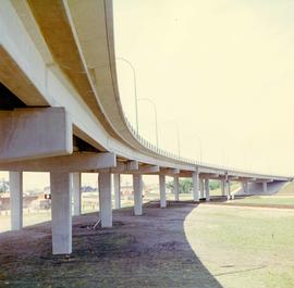
A colour photograph of the Nairn Overpass from below.
Metropolitan Corporation of Greater Winnipeg (Man.). Information Officer

Northdale Shopping Centre panorama
View of Northdale Shopping Centre, 963 Henderson Highway, 7.65 acres. From left to right: Loblaws Groceteria, Zeller's County Fair, various shops, the Royal Bank, the Canadian Imperial Bank of Commerce, A & P Food Store, Lord Wolseley School. Consists of 3 separate photographs pasted together on cardboard to create a panorama. The cardboard is a scrap made from an old sign of the Metropolitan Corporation of Greater Winnipeg (visible on the reverse). The cardboard is numbered “1”, presumably as part of a compilation with other shopping centre panoramas.
Metropolitan Corporation of Greater Winnipeg (Man.). Planning Division

Crossroads Shopping Centre panorama
View of Crossroads Shopping Centre, 1580 Regent Avenue W., 18 acres. From left to right: Woolco Department Store, Various shops, Safeway, Pacific 66 Gas Bar. Consists of 3 separate photographs pasted together on cardboard to create a panorama. The cardboard is a scrap made from an old sign of the Metropolitan Corporation of Greater Winnipeg (visible on the reverse). The cardboard is numbered “3”, presumably as part of a compilation with other shopping centre panoramas.
Metropolitan Corporation of Greater Winnipeg (Man.). Planning Division