
- i03977
- Item
- 1916
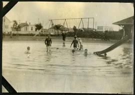
Children playing in a wading pool in Weston Park.
209 results with digital objects Show results with digital objects
Children playing in a wading pool in Weston Park.
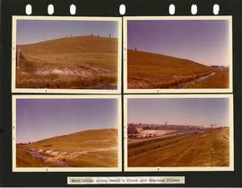
Westview Park – Saskatchewan Landfill – west slope
4 photographs of the west slope of Westview Park, along Omand’s Creek and Empress Street. Photographs are affixed to a black page.
Winnipeg (Man.). Parks and Recreation Department
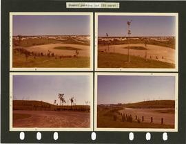
Westview Park – Saskatchewan Landfill – summit parking lot
4 photographs of the parking lot at the summit of Westview Park. Photographs are affixed to a black page.
Winnipeg (Man.). Parks and Recreation Department
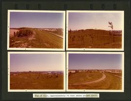
Westview Park – Saskatchewan Landfill – top of hill
4 photographs of the top of the hill of Westview Park, approximately 70 feet above street level. Photographs are affixed to a black page.
Winnipeg (Man.). Parks and Recreation Department
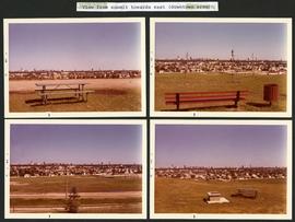
Westview Park – Saskatchewan Landfill – view from summit
4 photographs taken from the summit of Westview Park, facing east. Photographs are affixed to a black page.
Winnipeg (Man.). Parks and Recreation Department

New boulevards on street north from Palmerston Avenue.
View of new boulevards on an unidentified street in the Wolseley area, facing north from Palmerston Avenue.

Notre Dame Avenue facing west from Arlington Street
View of the boulevard on Notre Dame Avenue facing west, between Arlington and McPhillips Streets. Free Press Depot Number 2 can be seen on the right.

The second side of an album page with a photograph of a Parks Board supervised skating rink outside the Norhtland Knitting Company Building at 618 Arlington Street affixed.
Winnipeg (Man.). Parks and Recreation Department

Aerial view looking south from over Wesley Park at rear of United College
Date of photograph is approximate, ca. 1937.
Aerial view of Winnipeg looking south on Memorial Boulevard toward Legislative Building
Date of photograph is approximate, ca. 1935.

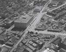
Central Business District: Aerial view - Central Winnipeg
Date of photograph is approximate, ca. 1947.
#2, P.R.M., Westminster and Canora - 1947

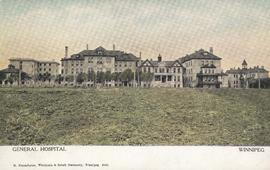
Winnipeg General Hospital and Alexandra Park
Postcard shows Winnipeg General Hospital in background, Bannatyne Avenue looking South across Alexandra Park. In foreground, Alexandra Park appears. Shows 1884 and 1897 buildings. Date of postcard is approximate, ca. 1897.
![Northwest Winnipeg [Aerial view]](/uploads/r/city-of-winnipeg-archives-amp-records-control-branch/4/f/3/4f37bff68f08b53a6e7296217f26c266711570595702620b7b89d115744d09e4/C0013_0000_0000_P0018_0025_001_142.jpg)
Northwest Winnipeg [Aerial view]
Aerial view of the Minto area. Inscription (on recto): WG A90 '41, 1941 - Northwest Winnipeg.
![Central Winnipeg between Portage and Notre Dame Avenues [Aerial view]](/uploads/r/city-of-winnipeg-archives-amp-records-control-branch/e/3/f/e3f90f80ff2b9d7dc2938509d7f4a5b4dfdfef9308ecfc0cfa38d5f1e2aa0bb8/C0013_0000_0000_P0018_0026_001_142.jpg)
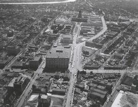
Central Winnipeg between Portage and Notre Dame Avenues [Aerial view]
Inscription (on recto): WG A158 8/6/1942 Central Wpg between Portage and Notre Dame Ave's.
![C.P.R. Yards looking West [Aerial view]](/uploads/r/city-of-winnipeg-archives-amp-records-control-branch/1/d/2/1d24b0471a50903dd76276838a7e169e4890a17020a9cfe6a0d34e153ebb9ec9/C0013_0000_0000_P0018_0027_001_142.jpg)
C.P.R. Yards looking West [Aerial view]
Inscription (on recto): WG A114 30-2-42 CPR [Canadian Pacific Railway] RR [Railroad] Yards looking West.
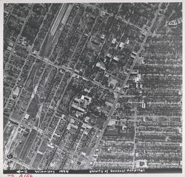
Aerial view of Vicinity of General Hospital, 1944
Description (on recto): WG A156, vicinity of General Hospital, Winnipeg, 1944. - Area around William Avenue and Sherbrook Street shown in photograph. - Photo credit: Royal Canadian Air Force Photograph.

Aerial view of RCAF Equipment Depot Number 2
Aerial photograph showing the Royal Canadian Air Force Equipment Depot Number 2, south of Brooklands and Weston. The Weston Shops are featured at the top of the photograph. The Inscription (on recto): NE. WG. F24 AP144 49.55N 97.07W #7 Equip. Depot Wpg [Winnipeg], 14-3-44, 15:00, 8" 2500'.