
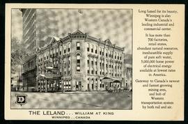
The Leland Hotel, William at King
- i01698
- Item
- [194-?]
Postcard shows Leland Hotel at William Avenue and King Street. Date of postcard is uncertain [before 1949].
The Leland Hotel, William at King
Postcard shows Leland Hotel at William Avenue and King Street. Date of postcard is uncertain [before 1949].
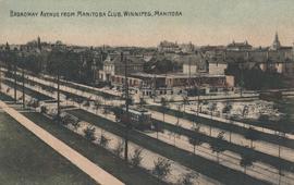
Broadway Avenue from Manitoba Club, Winnipeg
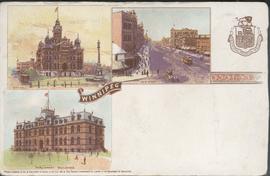
Canadian Postal Card showing Winnipeg City Hall, Main Street and Parliament Buildings
Postcard shows Winnipeg's second city hall (1886-1962), Main Street and Parliament buildings.
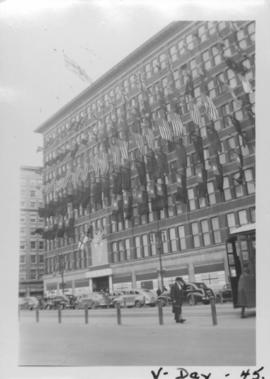
VE Day in Winnipeg showing Eaton's Building on Portage Avenue adorned with flags
Photograph shows Victory in Europe Day (VE Day) celebrations marking the end of World War 2 in Europe.

C.P.R. Depot and Royal Alexandra Hotel, Winnipeg, Manitoba
Photograph shows Canadian Pacific Railway depot and Royal Alexandra Hotel on Higgins Avenue. Date of photograph is approximate, ca. 1940.
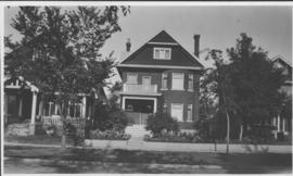
Our place - 49 Balmoral Place, Winnipeg, Manitoba

Postcard shows Portage Avenue, from Main Street looking west. Published by Valentine & Sons' Publishing Co., Ltd. Montreal and Toronto. Printed in Great Britain. Date of postcarcd is uncertain.

Main Street North, Winnipeg, Manitoba, Canada
Print is a photographic image of Main Street North. The McLaren Hotel, Hotel Cornwall and C.P.R. Station can be seen in photograph

Part of City of Winnipeg (1874-1971)
A photograph of flooding on Disraeli St during the 1950 flood. The photograph shows a child standing on a pile of lumber beside the flooded street.
Harold K. White Studio

Part of City of Winnipeg (1874-1971)
A photograph of children on Higgins Avenue during the 1950 flood. Piles of earth and sandbags line the street.
Harold K. White Studio

Part of City of Winnipeg (1874-1971)
A photograph of a flooded underpass on Higgins Avenue during the 1950 flood.
Harold K. White Studio

Pumping water on Robert Street
Part of City of Winnipeg (1874-1971)
A photograph of a pipe pouring water onto tracks on Robert Street (Galt Avenue) during the 1950 flood. A pile of wood is along one side of the street. The Ogilvie Flour Mill can be seen in the background.
Harold K. White Studio

North side of Lombard, Rorie to Main Street
Part of City of Winnipeg (1874-1971)
A photograph of storefronts and advertisements on the north side of Lombard Avenue, between Rorie Street and Main Street. The photograph is part of small album containing photographs of maps tracking the outbreak of typhoid from 1905 to 1909 and other scenes. Item is loose and at back of album.
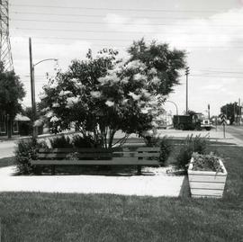
Japanese lilac tree on median of Provencher Boulevard
Photograph of Provencher Boulevard's median after Metro's beautification efforts, featuring a Japanese lilac tree, a bench, and other potted plants. A description of the photo used for publication is recorded on a separate piece of paper. Photo's reverse is stamped by the Parks and Protection Division of the Metro Government.
Metropolitan Corporation of Greater Winnipeg (Man.). Information Officer

Winnipeg, Main Street looking south, Summer 1875
Part of City of Winnipeg (1874-1971)
Photograph taken from top of Courthouse.
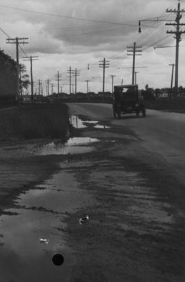
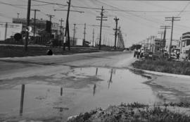
Main Street, corner Seven Oaks, Rainfall, June 29, 1932
Photograph is dated July 1, 1932.

Winnipeg Street Railway on Portage Avenue in front of Merchants Hotel
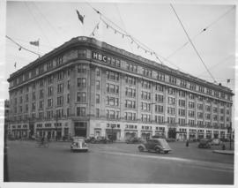
Hudson's Bay Company Store from Portage Avenue at Memorial Boulevard
Date of photograph is approximate, ca. 1942.
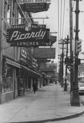
Overhanging Signs: North side of Portage Avenue looking East from Vaughan Street
Photograph shows signs for multiple businesses, including Picardy Lunches, Scientific Hairdressing, Credit Bureau. Date of photograph is uncertain, [196-?].