
- i00141
- Item
- 1950
Part of City of Winnipeg (1874-1971)
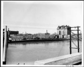
A photograph of the Main Street Bridge during the 1950 flood in Winnipeg. The Hotel Fort Garry can be seen in the background.
Harold K. White Studio
Part of City of Winnipeg (1874-1971)
A photograph of the Main Street Bridge during the 1950 flood in Winnipeg. The Hotel Fort Garry can be seen in the background.
Harold K. White Studio

Part of City of Winnipeg (1874-1971)
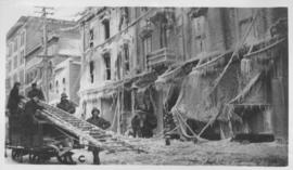
A photograph of floodwater and sandbag dikes outside 368 and 372 Main Street during the 1950 flood in Winnipeg.
Harold K. White Studio
Part of City of Winnipeg (1874-1971)
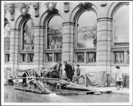
A photograph of floodwater and a pump outside the Royal Bank on Main Street during the 1950 flood in Winnipeg.
Harold K. White Studio

Part of City of Winnipeg (1874-1971)
Photograph shows the North End Farmer's Market (west side Main Street, north of Stella Avenue, looking west to King Street). Included in photograph: front entrance to market, automobiles parked on street, and North End Horse Exchange (523 King Street). Photograph likely taken from 919-921 Main Street by city employee.

Part of City of Winnipeg (1874-1971)
Photograph shows the North End Farmer's Market, looking east across Main Street (northwest Main Street and Stella Avenue). Included in photograph: stalls filled with vegetables and people walking through the market, Aime Bicycle Shop, 909 Main Street, two-storey brick building (899-905 Main Street), and Norquay School.
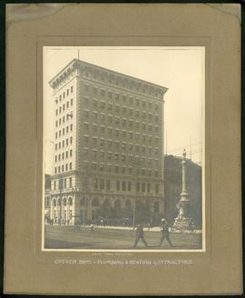
Union Bank Building – Cotter Brothers Plumbing and Heating
Part of Morris Block collection
Photograph mounted on cardboard of the Union Bank Building at Main St. and William Avenue and the Volunteer monument. The caption below the photograph implies that the photograph was taken by or for the Cotter Brothers – Plumbing and Heating Contractors.
Block, Morris

Main Street, south of Seven Oaks, 48 hours after rain
Date of photograph is July 8, 1932.
Industrial Bureau Exposition Building
Photograph shows the Industrial Bureau Exposition Building, also called the Board of Trade Building, at Main Street and Water Avenue (now William Stephenson Way). Date of photograph is approximate, ca. 1915.
Winnipeg City Hall, Recruiting Stand
Photograph shows Winnipeg's second City Hall (1886-1962) with recruiting stand at lower left: 'Sign Up for Overseas. Volunteer Today, Tomorrow May be too Late.' - Likely taken shortly after the start of World War 1.
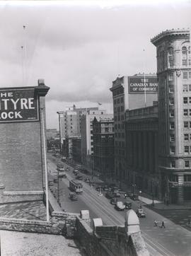
View of Main Street looking north from the Western Canada Loan Building
Photograph shows view of Main Street looking north from the roof of the Western Canada Loan Building, 392 Main Street at Portage Avenue. Date of photograph is approximate, ca. 1935.

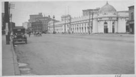
Main Street Winnipeg looking south from City Hall
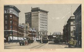
Postcard shows Main Street looking north from McDermot Avenue to Union Bank Building. Date of postcard is uncertain, [before 1949].
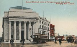
Bank of Montreal, corner of Portage Avenue and Main Street
Date of postcard is approximate, ca. 1912.
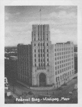
Photograph shows Federal building located on Main Street at Water Avenue.
![Kildonan Park [Aerial view]](/uploads/r/city-of-winnipeg-archives-amp-records-control-branch/f/5/8/f589f26a584950aadbe5b101158e69cde3cad16f0f0cf05dcbb2a97e34661f16/C0013_0000_0000_P0018_0037_001_142.jpg)
Inscription (on recto): WG M35: 2-18, 5 Mar. '45, Kildonan Park, Wpg [Winnipeg], appr. scale 1/12000.
![Vicinity of Elmwood Park [Aerial view]](/uploads/r/city-of-winnipeg-archives-amp-records-control-branch/c/6/d/c6dc0bd0b8c2199f232fe8c7f5245d25e681a6a759be00e013a35a7a1ecada23/C0013_0000_0000_P0018_0042_001_142.jpg)
Vicinity of Elmwood Park [Aerial view]
Inscription (on recto): WG M35: 3-16, 5 Mar '45, vicinity Elmwood Park Wpg, appr scale 1/12000.
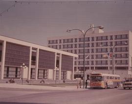
A photograph of the Civic Centre Complex, Winnipeg's third city hall (1964-present). Council Building, Administration Building, and public transit bus in view. Taken from William Avenue and Main Street, looking northwest. Date of photograph is uncertain, [197-?]. The photographer is likely Henry Kalen.
Kalen, Henry
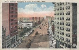
Main Street, looking north, Winnipeg, Man.
Postcard showing Main Street looking north from Bannatyne Avenue. Date of postcard is unknown.

Corner Portage Avenue and Main Street, Winnipeg, Manitoba
Print is a photographic image of the intersection of Portage Avenue and Main Street. Date of print is uncertain, [193-].