

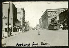
Main Street north of Portage Avenue
- i03455
- Item
- 1872
Photograph of a muddy Main Street in 1872, facing north from Portage Avenue and lined with shops on both sides, including a provisions store on the very right.
37 results with digital objects Show results with digital objects
Main Street north of Portage Avenue
Photograph of a muddy Main Street in 1872, facing north from Portage Avenue and lined with shops on both sides, including a provisions store on the very right.
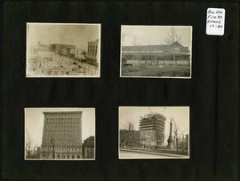
Photograph album of Winnipeg during WW1: Page 4
Item consists of a scrapbook page showing the Eaton's and Boyd Buildings (Item 17), unidentified building (Item 18),
Royal Bank Building and Leland Hotel (Item 19), Construction of Confederation Building with Volunteer Monument in foreground (Item 20). Dates of photographs are approximate, [ca. 1913].

Overhanging Signs: North side of Portage Avenue looking West from Young Street
Photograph shows signs for multiple businesses, including Club Morocco, Riviera Restaurant, Princeton Café Fish and Chips, Portage Credit Jewellers. Date of photograph is uncertain, [196-?].

Overhanging Signs: North side of Portage Avenue looking East from Langside Street
Photograph shows signs for multiple businesses, including Club Morocco and Aqua-Terre Pet & Sporting Goods. Date of photograph is uncertain, [196-?].

Overhanging Signs: North side of Portage Avenue
Photograph shows sign for Club Morocco. Date of photograph is uncertain, [196-?].
Portage looking east from around Carlton
Part of Morris Block collection
Photograph of a woman crossing Portage Avenue, looking east from around Carlton Street. The Eaton’s building can be seen on the right.
Block, Morris
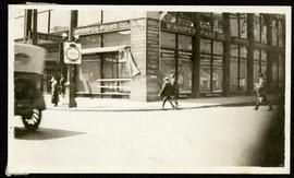
Builders’ Exchange Building at Portage and Hargrave
Part of Morris Block collection
Photograph of the Builders’ Exchange Building (later Times Building) at street level, at the corner of Portage Avenue and Hargrave Street. The Winnipeg Piano Co. storefront is featured.
Block, Morris
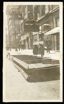
Storefronts on Portage, looking west from Donald
Part of Morris Block collection
Photograph of storefronts on the north side of Portage Avenue, looking west from around Donald Street.
Block, Morris
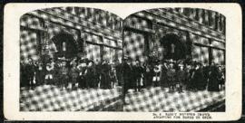
Eaton's promotional stereogram no. 2 – early morning crowd awaiting for doors to open
Part of Morris Block collection
Block, Morris
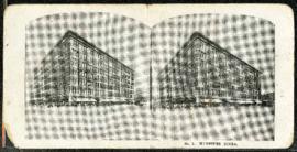
Eaton's promotional stereogram no. 1 - Winnipeg store
Part of Morris Block collection
Block, Morris

The Cove Restaurant, corner of Portage and Carlton
Photograph of "The Cove" Restaurant at 355 Portage Avenue, at Carlton Street. The photograph was taken from a building on Carlton Street looking southeast towards the Eaton's Building, Mitchell-Copp, Zeller's, and the Carlton Building.
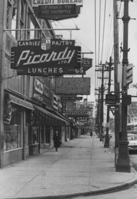
Overhanging Signs: North side of Portage Avenue looking East from Vaughan Street
Photograph shows signs for multiple businesses, including Picardy Lunches, Scientific Hairdressing, Credit Bureau. Date of photograph is uncertain, [196-?].

Westwood Shopping Centre panorama
View of Westwood Shopping Centre, 3276-3332 Portage Avenue, 10.2 acres. From left to right: various shops, motel, various shops and Assiniboia Public Library, Safeway Store, Marshall Wells, Perths, Westwood Pharmacy, various Shops, Zeller's County Fair, Auto Centre. Consists of 3 separate photographs pasted together on cardboard to create a panorama. The cardboard is a scrap made from an old sign of the Metropolitan Corporation of Greater Winnipeg (visible on the reverse). The cardboard is numbered “10”, presumably as part of a compilation with other shopping centre panoramas.
Metropolitan Corporation of Greater Winnipeg (Man.). Planning Division

Crestview Shopping Centre panorama
View of Crestview Shopping Centre, 3395 Portage Avenue, 8.3 acres. From left to right: Kmart Department Store, Dominion Store, Various Shops. Consists of 3 separate photographs pasted together on cardboard to create a panorama. The cardboard is a scrap made from an old sign of the Metropolitan Corporation of Greater Winnipeg (visible on the reverse). The cardboard is numbered “9”, presumably as part of a compilation with other shopping centre panoramas.
Metropolitan Corporation of Greater Winnipeg (Man.). Planning Division

Polo Park Shopping Centre panorama
View of Polo Park Shopping Centre, 1485 Portage Avenue, 41 acres. West side of shopping centre, north side of Portage Avenue between Empress Street and St. James Street. Left to Right: Winnipeg Stadium, Winnipeg Arena, Loblaws, Simpson Sears Marina, Simpson Sears Garden Shop, Simpson Sears Department Store, Simpson Sears Service Station. Consists of 4 separate photographs pasted together on cardboard to create a panorama. The cardboard is a scrap made from an old sign of the Metropolitan Corporation of Greater Winnipeg (visible on the reverse). The cardboard is numbered “11”, presumably as part of a compilation with other shopping centre panoramas.
Metropolitan Corporation of Greater Winnipeg (Man.). Planning Division

Polo Park Shopping Centre panorama
View of Polo Park Shopping Centre, 1485 Portage Avenue, 41 acres. East side of shopping centre. From left to right: the Pancake House, Simpsons-Sears, Perth's Dry Cleaners, Genser's Furniture, Daytons, Jack and Jill, Reward, Gordi's Restaurant, Ricki’s, addition to shopping centre under construction, Dominion Store, CJAY-TV Station (CKY-TV), Winnipeg Arena. Consists of 4 separate photographs pasted together on cardboard to create a panorama. The cardboard is a scrap made from an old sign of the Metropolitan Corporation of Greater Winnipeg (visible on the reverse). The cardboard is numbered “12”, presumably as part of a compilation with other shopping centre panoramas.
Metropolitan Corporation of Greater Winnipeg (Man.). Planning Division

Polo Park Shopping Centre panorama
View of Polo Park Shopping Centre, 1485 Portage Avenue, 41 acres. South side of shopping centre. Left to right: Winnipeg Motor Products, Motor Club, Simpson Sears Service Station, Simpson Sears Department Store. Consists of 3 separate photographs pasted together on cardboard to create a panorama. The cardboard is a scrap made from an old sign of the Metropolitan Corporation of Greater Winnipeg (visible on the reverse). The cardboard is numbered “13”, presumably as part of a compilation with other shopping centre panoramas.
Metropolitan Corporation of Greater Winnipeg (Man.). Planning Division
Storefronts on Portage Avenue between Carlton and Hargrave Streets
Cars and shoppers in front of stores on the north side of Portage Avenue, between Carlton and Hargrave Streets. Featured are The Berryhill Shoe Store in the Enderton / Mitchell-Copp Building, the Bank of Montreal, Zeller's (Zellers), and Rannards Shoes in

Portage Avenue looking west from Colony Street
A view of Portage Avenue looking west from Colony Street. The Hudson's Bay Company Building is featured prominantly and the Power Building and the Boyd Building are visible farther west.

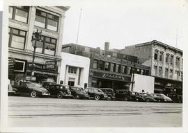
Storefronts on Portage Avenue between Carlton and Hargrave Streets
Cars and shoppers in front of stores on the north side of Portage Avenue, between Carlton and Hargrave Streets. Featured are The Berryhill Shoe Store in the Enderton / Mitchell-Copp Building, the Bank of Montreal, and Zeller's (Zellers).