

- i00168
- Item
- 1950
Part of City of Winnipeg (1874-1971)
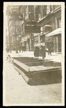
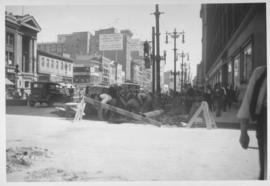
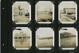
A photograph of floodwater and sandbag dikes outside 368 and 372 Main Street during the 1950 flood in Winnipeg.
Harold K. White Studio
Part of City of Winnipeg (1874-1971)
A photograph of floodwater and sandbag dikes outside 368 and 372 Main Street during the 1950 flood in Winnipeg.
Harold K. White Studio
Storefronts on Portage, looking west from Donald
Part of Morris Block collection
Photograph of storefronts on the north side of Portage Avenue, looking west from around Donald Street.
Block, Morris
Winnipeg Street Railway on Portage Avenue in front of Merchants Hotel
View of Main Street looking north from the Western Canada Loan Building
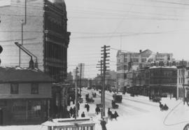
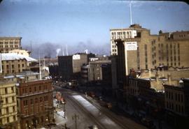
Photograph shows view of Main Street looking north from the roof of the Western Canada Loan Building, 392 Main Street at Portage Avenue. Date of photograph is approximate, ca. 1935.

Photograph shows old St. James Bridge approach, looking North up present Kintrye Street. Viscount Gort site centre right/Hydro sub-station - St. James Street and Portage Avenue far left. Date of photograph is uncertain [after 1932].

Overhanging Signs: North side of Portage Avenue looking East from Langside Street
Photograph shows signs for multiple businesses, including Club Morocco and Aqua-Terre Pet & Sporting Goods. Date of photograph is uncertain, [196-?].

Overhanging Signs: North side of Portage Avenue
Photograph shows sign for Club Morocco. Date of photograph is uncertain, [196-?].
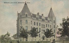
Wesley College, 515 Portage Avenue, northwest corner of Portage Avenue and Balmoral Street
Date of postcard is approximate, ca. 1905.
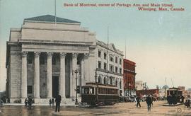
Bank of Montreal, corner of Portage Avenue and Main Street
Date of postcard is approximate, ca. 1912.
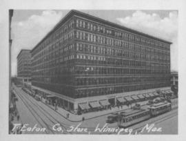
T. Eaton Co. Store, Winnipeg, Man.
Photograph shows Eaton's Department Store at Portage Avenue and Donald Street.
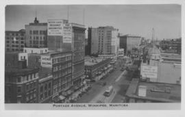
Portage Avenue, Winnipeg, Manitoba
Photograph shows view of Paris and Avenue buildings and Bank of Nova Scotia building. Date of photograph is approximate, ca. 1940.
![Assiniboine to Airport, St. James [Aerial view]](/uploads/r/city-of-winnipeg-archives-amp-records-control-branch/c/9/8/c986dd715644d9b7d48854b59c8285d029a7db80cb4798af462d336b696964c9/C0013_0000_0000_P0018_0043_001_142.jpg)
Assiniboine to Airport, St. James [Aerial view]
Inscription (on recto): WG M35: 7-16, 5 Mar '45, Assiniboine to Airport, St. James, app scale 1/12000.

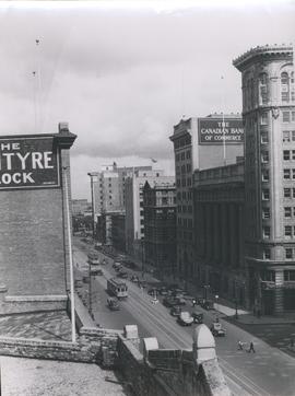
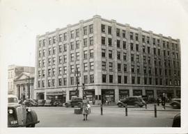
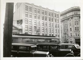
Corner Portage Avenue and Main Street, Winnipeg, Manitoba
Print is a photographic image of the intersection of Portage Avenue and Main Street. Date of print is uncertain, [193-].
Scrapbook of Corporal Wallace – page 7
Page 7 of a photograph scrapbook made by Corporal John Wallace in April 1940. Photographs depict Fort Osborne Barracks and its Parade Square, soldiers marching, the Civic Auditorium, and the Mall Hotel on Portage Avenue between Colony and Balmoral Streets.
Wallace, John

The Cove Restaurant, corner of Portage and Carlton
Photograph of "The Cove" Restaurant at 355 Portage Avenue, at Carlton Street. The photograph was taken from a building on Carlton Street looking southeast towards the Eaton's Building, Mitchell-Copp, Zeller's, and the Carlton Building.
Storefronts in the Power Building
A view of cars and shoppers outside the Power Building at the corner of Portage Avenue and Vaughan Street. Street level storefronts include the Winnipeg Electric Company showroom and Rexall / Liggett's drug store. Above are the offices of Western Empire L
Power Building and Hudson's Bay Company Building
View of the North side of the corner of Portage Avenue and Vaughan Street, featuring the Power Building and Hudson's Bay Company Building. I front are parked cars and a street car passing by.

Polo Park Shopping Centre panorama
View of Polo Park Shopping Centre, 1485 Portage Avenue, 41 acres. South side of shopping centre. Left to right: Winnipeg Motor Products, Motor Club, Simpson Sears Service Station, Simpson Sears Department Store. Consists of 3 separate photographs pasted together on cardboard to create a panorama. The cardboard is a scrap made from an old sign of the Metropolitan Corporation of Greater Winnipeg (visible on the reverse). The cardboard is numbered “13”, presumably as part of a compilation with other shopping centre panoramas.
Metropolitan Corporation of Greater Winnipeg (Man.). Planning Division