
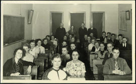
Jon Bjarnason Academy – grade 12 class and faculty
- i04033
- Item
- [1937 or 1938]
Group photograph of the 1937-38 grade 12 class at Jon Bjarnason Academy (652 Home Street), seated in their desks with faculty standing behind them.
195 results with digital objects Show results with digital objects
Jon Bjarnason Academy – grade 12 class and faculty
Group photograph of the 1937-38 grade 12 class at Jon Bjarnason Academy (652 Home Street), seated in their desks with faculty standing behind them.

Thoroughfares: Academy Road at Wellington Crescent
View of cars and cyclists heading down Academy Road towards Wellington Crescent and the Maryland Bridge. A small portion of Misericordia Hospital can be seen across the bridge.

Thoroughfares: Academy Road at Wellington Crescent
View of cars and cyclists heading down Academy Road towards Wellington Crescent and the Maryland Bridge. The cupola of Misericordia Hospital can be seen across the bridge.

Polo Park Shopping Centre panorama
View of Polo Park Shopping Centre, 1485 Portage Avenue, 41 acres. East side of shopping centre. From left to right: the Pancake House, Simpsons-Sears, Perth's Dry Cleaners, Genser's Furniture, Daytons, Jack and Jill, Reward, Gordi's Restaurant, Ricki’s, addition to shopping centre under construction, Dominion Store, CJAY-TV Station (CKY-TV), Winnipeg Arena. Consists of 4 separate photographs pasted together on cardboard to create a panorama. The cardboard is a scrap made from an old sign of the Metropolitan Corporation of Greater Winnipeg (visible on the reverse). The cardboard is numbered “12”, presumably as part of a compilation with other shopping centre panoramas.
Metropolitan Corporation of Greater Winnipeg (Man.). Planning Division

Polo Park Shopping Centre panorama
View of Polo Park Shopping Centre, 1485 Portage Avenue, 41 acres. West side of shopping centre, north side of Portage Avenue between Empress Street and St. James Street. Left to Right: Winnipeg Stadium, Winnipeg Arena, Loblaws, Simpson Sears Marina, Simpson Sears Garden Shop, Simpson Sears Department Store, Simpson Sears Service Station. Consists of 4 separate photographs pasted together on cardboard to create a panorama. The cardboard is a scrap made from an old sign of the Metropolitan Corporation of Greater Winnipeg (visible on the reverse). The cardboard is numbered “11”, presumably as part of a compilation with other shopping centre panoramas.
Metropolitan Corporation of Greater Winnipeg (Man.). Planning Division

Polo Park Shopping Centre panorama
View of Polo Park Shopping Centre, 1485 Portage Avenue, 41 acres. South side of shopping centre. Left to right: Winnipeg Motor Products, Motor Club, Simpson Sears Service Station, Simpson Sears Department Store. Consists of 3 separate photographs pasted together on cardboard to create a panorama. The cardboard is a scrap made from an old sign of the Metropolitan Corporation of Greater Winnipeg (visible on the reverse). The cardboard is numbered “13”, presumably as part of a compilation with other shopping centre panoramas.
Metropolitan Corporation of Greater Winnipeg (Man.). Planning Division

1932 Relief Works and Committee Winnipeg
Photograph collage of the 1932 Winnipeg Relief Works and Committee. Portraits of committee members are surrounding photographs of projects the committee had worked on. The committee members are, clockwise from top left: Alderman John Blumberg, Alderman H. Andrews, City Clerk Magnus Peterson, Alderman J.A. Barry, Alderman A.A. Ryley, Alderman W.B. Simpson, City Engineer W.P. Brereton, G.W. Northwood, Alderman E.D. Honeyman, Mayor Ralph Webb, Alderman J.A. McKerschar, A. MacNamara, Resident Engineer A.J. Taunton, Alderman L.F. Borrowman, and Alderman C.E. Simonite. The works projects showcased in the center are, clockwise from top left: the Main Street Bridge, the Norwood Bridge, the Assiniboine Park Bridge, the Winnipeg Auditorium, the Sargent Park Swimming Pool, and the Salter Street Bridge. Created by Robson Photo.
Scrapbook of Corporal Wallace – page 7
Page 7 of a photograph scrapbook made by Corporal John Wallace in April 1940. Photographs depict Fort Osborne Barracks and its Parade Square, soldiers marching, the Civic Auditorium, and the Mall Hotel on Portage Avenue between Colony and Balmoral Streets.
Wallace, John
Photograph album of Winnipeg during WW1: Page 3
Item consists of a scrapbook page showing the Young Men's Christian Association (YMCA) Building at 301 Vaughan Street (Item 13); view of Portage Avenue with Eaton's and Boyd buildings in foreground and Hotel Fort Garry in the background (Item 14); view of Ashford's Bakery at Portage Avenue and Furby Street, facing south towards Broadway (Item 15); Vaughan Street facing north towards St. Paul's College on Ellice Avenue (Item 16). Dates of photographs are approximate, [ca. 1913].

A military funeral, Broadway and Spence Streets, Winnipeg - 1914
Photograph taken at time of World War 1.
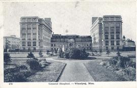
General Hospital - Winnipeg, Man.
Item consists of a postcard in printed format that shows the Winnipeg General Hospital. Date of postcard is unknown.
![Legislative Building and Central Winnipeg [Aerial view]](/uploads/r/city-of-winnipeg-archives-amp-records-control-branch/5/1/1/511af88a9e92fe7d7d3edda2bdaee6fc5652013532efb88411d3403dfcf85917/C0013_0000_0000_P0018_0046_001_142.jpg)
Legislative Building and Central Winnipeg [Aerial view]
Inscription (on recto): WG M35: 4-5, 5 Mar '45, Legislative Bldg and Central Wpg, appr. scale 1/12000.
![Sargent Park [Aerial View]](/uploads/r/city-of-winnipeg-archives-amp-records-control-branch/e/5/1/e51b6ff83bb626c524f2415a4d84c08187de0f175c746cbde40dcf11e700b8eb/C0013_0000_0000_P0018_0039_001_142.jpg)
Inscription (on recto): WG. M35: 5-10, 5 Mar' 45, Sgt Park Vicinity, appr. scale 1/12000.
![Sargent Park vicinity [Aerial view]](/uploads/r/city-of-winnipeg-archives-amp-records-control-branch/6/d/b/6dbefceeef372f0514de159e1569f5aba581dc63a4d454200688557662b9ce22/C0013_0000_0000_P0018_0038_001_142.jpg)
Sargent Park vicinity [Aerial view]
Inscription (on recto): WG M35: 5-9, 5 Mar. '45, Sgt Park Vicinity, appr. scale 1/12000.

Aerial view of RCAF Equipment Depot Number 2
Aerial photograph showing the Royal Canadian Air Force Equipment Depot Number 2, south of Brooklands and Weston. The Weston Shops are featured at the top of the photograph. The Inscription (on recto): NE. WG. F24 AP144 49.55N 97.07W #7 Equip. Depot Wpg [Winnipeg], 14-3-44, 15:00, 8" 2500'.
![Logan Avenue and Salter Street [Aerial view]](/uploads/r/city-of-winnipeg-archives-amp-records-control-branch/9/8/0/980f8ba4214d821c9b49366ae35d9ea9ed5b7f44366c5cd894e04befdd6c7a22/C0013_0000_0000_P0018_0033_001_142.jpg)
Logan Avenue and Salter Street [Aerial view]
Inscription (on recto): A161 3-9-43 Logan Ave and Salter St Wp [Winnipeg?] about 4000' 5".
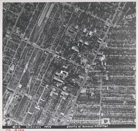
Aerial view of Vicinity of General Hospital, 1944
Description (on recto): WG A156, vicinity of General Hospital, Winnipeg, 1944. - Area around William Avenue and Sherbrook Street shown in photograph. - Photo credit: Royal Canadian Air Force Photograph.
![C.P.R. Yards looking West [Aerial view]](/uploads/r/city-of-winnipeg-archives-amp-records-control-branch/1/d/2/1d24b0471a50903dd76276838a7e169e4890a17020a9cfe6a0d34e153ebb9ec9/C0013_0000_0000_P0018_0027_001_142.jpg)
C.P.R. Yards looking West [Aerial view]
Inscription (on recto): WG A114 30-2-42 CPR [Canadian Pacific Railway] RR [Railroad] Yards looking West.
![Central Winnipeg between Portage and Notre Dame Avenues [Aerial view]](/uploads/r/city-of-winnipeg-archives-amp-records-control-branch/e/3/f/e3f90f80ff2b9d7dc2938509d7f4a5b4dfdfef9308ecfc0cfa38d5f1e2aa0bb8/C0013_0000_0000_P0018_0026_001_142.jpg)
Central Winnipeg between Portage and Notre Dame Avenues [Aerial view]
Inscription (on recto): WG A158 8/6/1942 Central Wpg between Portage and Notre Dame Ave's.