
![Elliot [Dawson Kerr Elliot]](/uploads/r/city-of-winnipeg-archives-amp-records-control-branch/8/6/1/8619c89a5dbeccdf7479c992140adcc34fd27d6be672944749bd7b64d9d3bfb8/F0001_0083_0000_A0569_0000_015_142.jpg)
- i00063
- Item
- 1884
Part of City of Winnipeg (1874-1971)
Photograph shows Dawson Kerr Elliot (1853-1945), local merchant. Date of photograph is probable, [1884?].
Bennetto, Israel
Part of City of Winnipeg (1874-1971)
Photograph shows Dawson Kerr Elliot (1853-1945), local merchant. Date of photograph is probable, [1884?].
Bennetto, Israel
Part of City of Winnipeg (1874-1971)
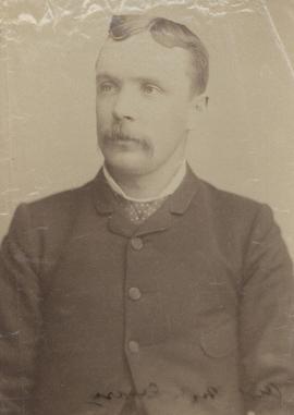
Photograph shows William Forsythe McCreary (1855-1906), former Alderman, 1884, 1895-1896. Date of photograph is probable, [1884?].
Bennetto, Israel
Part of City of Winnipeg (1874-1971)
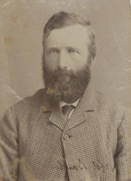
Photograph shows Joshua Calloway, former Alderman, 1884, 1886-1891. Date of photograph is probable, [1884?].
Bennetto, Israel
Part of City of Winnipeg (1874-1971)
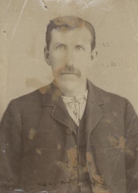
Photograph shows Nicholas Bawlf (1849-1914), former Alderman, 1883-1884. Date of photograph is probable, [1884?].
Bennetto, Israel
![Handscomb [Charles W. Handscomb]](/uploads/r/city-of-winnipeg-archives-amp-records-control-branch/8/4/8/84853e5849b5f90874e2c280acbcdc855195713255ccebb76bad790a5504db21/F0001_0083_0000_A0569_0000_025_142.jpg)
Handscomb [Charles W. Handscomb]
Part of City of Winnipeg (1874-1971)
Photograph shows Charles W. Handscomb (1867-1906). Date of photograph is probable, [1884?].
Bennetto, Israel
![Osborne, Asst. Chamberlain[?]](/uploads/r/city-of-winnipeg-archives-amp-records-control-branch/2/5/a/25a6e4d25b5924a851e738e37c5eeeee346740fbc679a8baf9ae65051b7d3c6d/F0001_0083_0000_A0569_0000_034_142.jpg)
Part of City of Winnipeg (1874-1971)
Date of photograph is probable, [1884?].
Bennetto, Israel
![Tax Collector Hadskiss [George Hugh Hadskis]](/uploads/r/city-of-winnipeg-archives-amp-records-control-branch/f/1/d/f1dbb3f1f6e1ded624285a7b15b195e203ed4b128f2d4b93aa1cc06e4c055b89/F0001_0083_0000_A0569_0000_035_142.jpg)
Tax Collector Hadskiss [George Hugh Hadskis]
Part of City of Winnipeg (1874-1971)
Photograph shows George Hugh Hadskis (1838-1915), former Tax Collector. Date of photograph is probable, [1884?].
Bennetto, Israel
Part of City of Winnipeg (1874-1971)
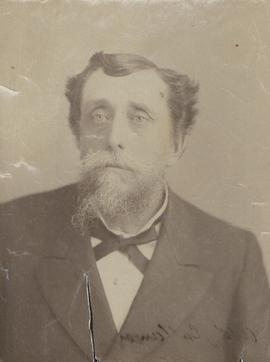
Photograph shows George Henry Ham (1847-1926), former Alderman, 1883-1884. Date of photograph is probable, [1884?].
Bennetto, Israel

Part of City of Winnipeg (1874-1971)
A photograph of flooding in a residential area of Winnipeg during the 1950 flood. The photograph was taken at the intersection of Disraeli and Euclid.
Harold K. White Studio

Foot of Robert Street (Galt Ave)
Part of City of Winnipeg (1874-1971)
A photograph of the Eaton's printing plant and warehouse on Robert Street (Galt Avenue) during the 1950 flood. The building is surrounded by a sandbag dike and water.
Harold K. White Studio

Part of City of Winnipeg (1874-1971)
A photograph of high water surrounding a power house during the 1950 flood.
Harold K. White Studio

Part of City of Winnipeg (1874-1971)
A photograph of high water surrounding a causeway that ran to the Rover Street hydro station during the 1950 flood.
Harold K. White Studio
Part of City of Winnipeg (1874-1971)
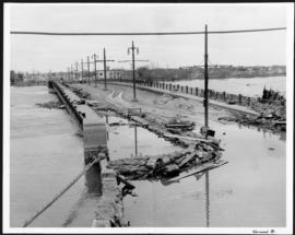
A photograph of the flooded Norwood Bridge during the 1950 flood in Winnipeg.
Harold K. White Studio
Part of City of Winnipeg (1874-1971)
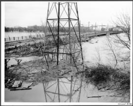
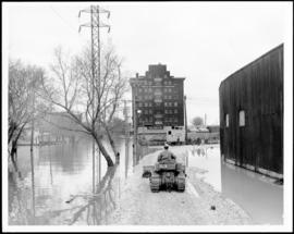
A photograph of a hydro tower and the flooded Norwood Bridge during the 1950 flood in Winnipeg.
Harold K. White Studio
Main Street looking south from Main Street Bridge
Part of City of Winnipeg (1874-1971)
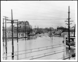
A photograph of flooded Main Street, looking south from the Main Street Bridge, during the 1950 flood in Winnipeg.
Harold K. White Studio

Winnipeg Electric Company building
Part of City of Winnipeg (1874-1971)
A photograph of the Winnipeg Electric Company building surrounded by water during the 1950 flood. Two men are in a boat in the floodwater outside the building.
Harold K. White Studio
Water Street from Provencher Bridge before causeway was built
Part of City of Winnipeg (1874-1971)
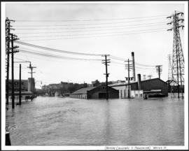
A photograph of flooded Water Street, taken from the Provencher Bridge, during the 1950 flood in Winnipeg. This photograph was taken before the causeway down Water Street was built.
Harold K. White Studio

Part of City of Winnipeg (1874-1971)
A photograph of a large pump on a residential street during the 1950 flood in Winnipeg.
Harold K. White Studio
Part of City of Winnipeg (1874-1971)
A photograph of a causeway near an underpass on Anabella Street during the 1950 flood in Winnipeg. A city employee is driving some equipment down the causeway.
Harold K. White Studio
Part of City of Winnipeg (1874-1971)
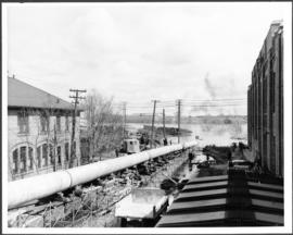
A photograph of a long pipe pumping water during the 1950 flood in Winnipeg.
Harold K. White Studio