
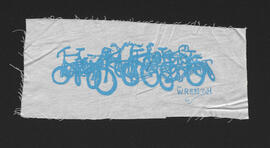
The W.R.E.N.C.H. bike pile logo screen print
- i04787
- Pièce
- 2015
Fait partie de The W.R.E.N.C.H. Winnipeg Cycling Archive collection
Art by Laura Tait.
Sans titre
282 résultats avec objets numériques Afficher les résultats avec des objets numériques
The W.R.E.N.C.H. bike pile logo screen print
Fait partie de The W.R.E.N.C.H. Winnipeg Cycling Archive collection
Art by Laura Tait.
Sans titre
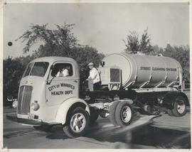
Fait partie de City of Winnipeg Archives Photograph collection
Photograph shows a street cleaning truck from the City of Winnipeg Health Department's Street Cleaining Division. Two City workers can be seen in the photograph. Date of photograph is uncertain.

Arlington Bridge from top of chimney
Fait partie de City of Winnipeg Archives Photograph collection
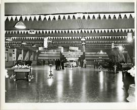
Fait partie de City of Winnipeg Archives Photograph collection
A car show likely held at the Civic Auditorium on Vaughan Street. Several cars are on display from brands such as Hudson and Austin.
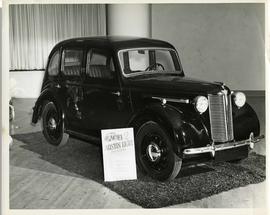
Austin Eight Saloon at car show
Fait partie de City of Winnipeg Archives Photograph collection
An Austin Eight Saloon model car at a car show likely held in the Civic Auditorium on Vaughan Street.
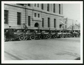
Police cars outside Rupert Avenue Police Station
Fait partie de City of Winnipeg Archives Photograph collection
A photograph of the Police Station and police car fleet on Rupert Avenue, taken ca. 1930.
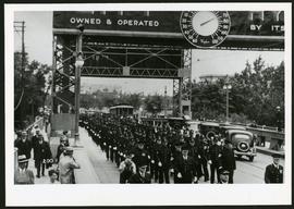
Police on Osborne Street Bridge during 1935 parade
Fait partie de City of Winnipeg Archives Photograph collection
A photograph of a parade on Osborne Street Bridge, taken 1935.

Rossmere Shopping Centre panorama
Fait partie de City of Winnipeg Archives Photograph collection
View of Rossmere Shopping Centre, 1070 Henderson Highway, southwest corner Rowandale, 4.25 acres. From left to right: a garage or car wash, Red River Co-Op Store, Rossmere Lanes Bowling Alley, Library, Dry Cleaners, Co-operators Credit Union Society Limited, Rowandale Baptist Church, Rowandale Apartments, Red River Co-Op Gas Station. Consists of 3 separate photographs pasted together on cardboard to create a panorama. The cardboard is a scrap made from an old sign of the Metropolitan Corporation of Greater Winnipeg (visible on the reverse). The cardboard is numbered “2”, presumably as part of a compilation with other shopping centre panoramas.
Sans titre

Southgate Shopping Centre panorama
Fait partie de City of Winnipeg Archives Photograph collection
View of Southgate Village Shopping Centre, 1305-1341 Pembina Highway at the southwest corner of McGillivray Boulevard, 3.3 acres. From left to right: Pembina Curling Rink, Imperial Cleaners, Safeway, The Place, Young Togs, Reid Marshall Pharmacy, The Village Gift Shop, The French Salon, Marshall Wells, The Toronto Dominion Bank, Safeway gas bar. Consists of 3 separate photographs pasted together on cardboard to create a panorama. The cardboard is a scrap made from an old sign of the Metropolitan Corporation of Greater Winnipeg (visible on the reverse). The cardboard is numbered “7”, presumably as part of a compilation with other shopping centre panoramas.
Sans titre

Westwood Shopping Centre panorama
Fait partie de City of Winnipeg Archives Photograph collection
View of Westwood Shopping Centre, 3276-3332 Portage Avenue, 10.2 acres. From left to right: various shops, motel, various shops and Assiniboia Public Library, Safeway Store, Marshall Wells, Perths, Westwood Pharmacy, various Shops, Zeller's County Fair, Auto Centre. Consists of 3 separate photographs pasted together on cardboard to create a panorama. The cardboard is a scrap made from an old sign of the Metropolitan Corporation of Greater Winnipeg (visible on the reverse). The cardboard is numbered “10”, presumably as part of a compilation with other shopping centre panoramas.
Sans titre

Aerial of 1974 Flood – Bergen Cutoff Bridge
Fait partie de City of Winnipeg Archives Photograph collection
Aerial photograph of the Bergen Cutoff Bridge during the 1974 Flood. The photograph faces northwest from Kildonan Drive in North Kildonan across the Red River towards Kildonan Park and Old Kildonan. The photographs were taken by the Department of Environmental Planning.
Sans titre
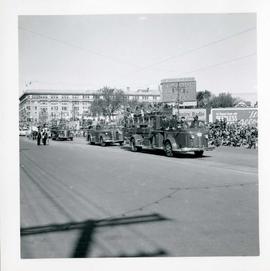
Winnipeg's 75th Anniversary parade - fire trucks
Fait partie de City of Winnipeg Archives Photograph collection
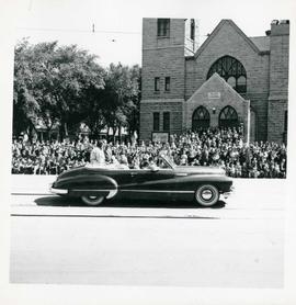
Winnipeg's 75th Anniversary parade - car carrying women
Fait partie de City of Winnipeg Archives Photograph collection

Winnipeg's 75th Anniversary parade - car with skull and crossbones labelled "Dunc Johnny"
Fait partie de City of Winnipeg Archives Photograph collection

Winnipeg's 75th Anniversary parade - Olympic figure skating champion Barbara Ann Scott
Fait partie de City of Winnipeg Archives Photograph collection
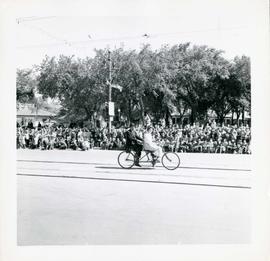
Winnipeg's 75th Anniversary parade - two person bicycle
Fait partie de City of Winnipeg Archives Photograph collection
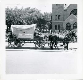
Winnipeg's 75th Anniversary parade - The Outlet Store float
Fait partie de City of Winnipeg Archives Photograph collection
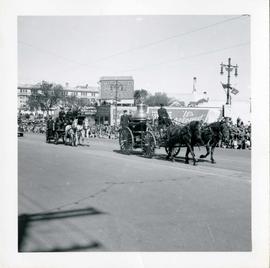
Winnipeg's 75th Anniversary parade - horse drawn fire engines
Fait partie de City of Winnipeg Archives Photograph collection
Fait partie de William Smaill fonds
Item consists of a photo album created by William Smaill, Superintendent of the Winnipeg Aqueduct Construction Company, Ltd. The album contains photographs of the aqueduct’s construction, company men and their families, recreation, camps and homes used during construction, the Greater Winnipeg Water District Railway, and the surrounding landscape (Shoal Lake, Whitemouth River, Indian Bay, Birch River). There are also several photos of Winnipeg during Decoration Day 1914, photos of Mayors T.R. Deacon, Thomas Sharpe, and R.D. Waugh, and two photos of an Anishinaabe camp at Kekekoziibii Shoal Lake 40 First Nation.
The photos are heavily annotated. The annotations consist of names, locations, descriptions, and sometimes the section or specific mile of the aqueduct. A few photos appear to be missing and there are several loose pages with similar content. The photos are arranged somewhat chronologically – photos from 1914 generally precede photos from 1915 – but there are many exceptions.
Sans titre

Fait partie de The W.R.E.N.C.H. Winnipeg Cycling Archive collection