

- i00123
- Item
- May 15, 1950
Part of City of Winnipeg (1874-1971)
A photograph of children on Higgins Avenue during the 1950 flood. Piles of earth and sandbags line the street.
Harold K. White Studio
3358 results with digital objects Show results with digital objects
Part of City of Winnipeg (1874-1971)
A photograph of children on Higgins Avenue during the 1950 flood. Piles of earth and sandbags line the street.
Harold K. White Studio

Part of City of Winnipeg (1874-1971)
A photograph of a flooded underpass on Higgins Avenue during the 1950 flood.
Harold K. White Studio

Pumping water on Robert Street
Part of City of Winnipeg (1874-1971)
A photograph of a pipe pouring water onto tracks on Robert Street (Galt Avenue) during the 1950 flood. A pile of wood is along one side of the street. The Ogilvie Flour Mill can be seen in the background.
Harold K. White Studio

Foot of Robert Street (Galt Ave)
Part of City of Winnipeg (1874-1971)
A photograph of the Eaton's printing plant and warehouse on Robert Street (Galt Avenue) during the 1950 flood. The building is surrounded by a sandbag dike and water.
Harold K. White Studio
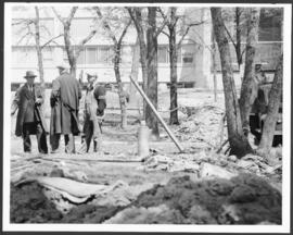
Part of City of Winnipeg (1874-1971)
A photograph of three men building a dike during the 1950 flood.
Harold K. White Studio
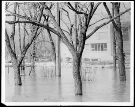
Part of City of Winnipeg (1874-1971)
A photograph of floodwater surrounding trees during the 1950 flood. A building protected by a sandbag dike is in the background.
Harold K. White Studio

Part of City of Winnipeg (1874-1971)
A photograph of high water surrounding a power house during the 1950 flood.
Harold K. White Studio

Causeway to Rover Street Station
Part of City of Winnipeg (1874-1971)
A photograph of high water surrounding a causeway that ran to the Rover Street hydro station during the 1950 flood.
Harold K. White Studio

Part of City of Winnipeg (1874-1971)
A photograph of high water surrounding a causeway that ran to the Rover Street hydro station during the 1950 flood.
Harold K. White Studio

Part of City of Winnipeg (1874-1971)
A photograph of the Rover Street hydro station, surrounded by water, during the 1950 flood.
Harold K. White Studio

Part of City of Winnipeg (1874-1971)
A photograph of the Rover Street hydro station, surrounded by water, during the 1950 flood.
Harold K. White Studio

Part of City of Winnipeg (1874-1971)
A photograph of the Rover Street hydro station, surrounded by water, during the 1950 flood. A group of people are walking on the sandbag dike that surrounds the building.
Harold K. White Studio
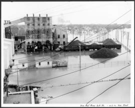
From roof of Rover Sub Station. W.E. Co. Gas Plant
Part of City of Winnipeg (1874-1971)
A photograph of flooding, taken from the roof of the Rover Street hydro station, during the 1950 flood.
Harold K. White Studio
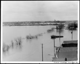
Louise and C.P.R. Bridge from top of Rover Station
Part of City of Winnipeg (1874-1971)
A photograph of the flooded Red River, nearly submerging the Louise and CPR bridges, taken from the roof of the Rover Street hydro station. Other flooded buildings can also be seen.
Harold K. White Studio
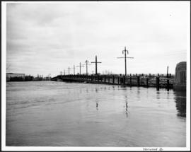
Part of City of Winnipeg (1874-1971)
A photograph of the flooded Norwood Bridge during the 1950 flood in Winnipeg.
Harold K. White Studio
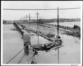
Part of City of Winnipeg (1874-1971)
A photograph of the flooded Norwood Bridge during the 1950 flood in Winnipeg.
Harold K. White Studio
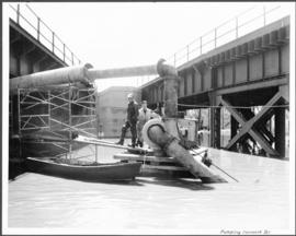
Part of City of Winnipeg (1874-1971)
A photograph of two men working with pumps to remove water from the Norwood Bridge during the 1950 flood in Winnipeg.
Harold K. White Studio
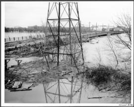
Part of City of Winnipeg (1874-1971)
A photograph of a hydro tower and the flooded Norwood Bridge during the 1950 flood in Winnipeg.
Harold K. White Studio
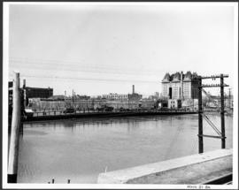
Part of City of Winnipeg (1874-1971)
A photograph of the Main Street Bridge during the 1950 flood in Winnipeg. The Hotel Fort Garry can be seen in the background.
Harold K. White Studio
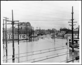
Main Street looking south from Main Street Bridge
Part of City of Winnipeg (1874-1971)
A photograph of flooded Main Street, looking south from the Main Street Bridge, during the 1950 flood in Winnipeg.
Harold K. White Studio