
- d00362
- File
- 1939, [ca. 1966]
Photographs of buildings on Portage Avenue including the Bank of Montreal, Zeller's, the Power Building, Winnipeg Electric Co. and the Royal Bank Building.
957 results with digital objects Show results with digital objects
Photographs of buildings on Portage Avenue including the Bank of Montreal, Zeller's, the Power Building, Winnipeg Electric Co. and the Royal Bank Building.
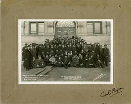
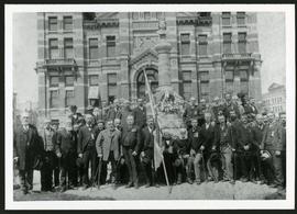
Winnipeg Battery Field Artillery (2nd Contingent)
Group photograph of the Winnipeg Battery Field Artillery, Second Contingent taken on November 9, 1914. The photo is captioned "Anglo, Franco, Belge, Russian, Austro, Turko, German War" and is signed Corporal Pryce.

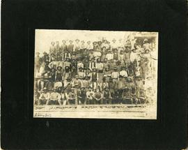
Civic Cricket Club, 1907 Manitoba Champions
Group photograph of the 1907 Civic Cricket Club champions of Manitoba. A caption on the front of the photograph claims the players' names are on the photograph's reverse, but there appear to be no names written.
Group photo of workers at Stony Mountain Quarry
A group photograph of Stony Mountain Quarry workers posing next to a railroad track.
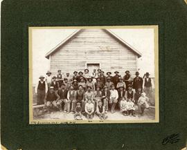
Group photo of workers at Little Mountain Quarry
A group photograph of Little Mountain Quarry workers posing in front of a small wooden building. There are several infants and small children present, including three at the front identified as Chuck, Geo, and Tom.
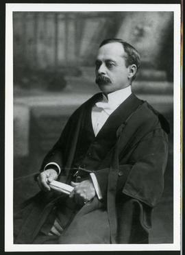
Police Magistrate George William Baker
A photograph of Magistrate C.W. Baker, taken 1902 or 1903.

Chief Constable John S. Ingram
A photograph of John S. Ingram, Chief Constable, taken 1874 or 1875.
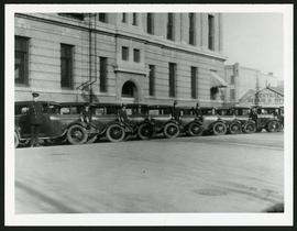
Police cars outside Rupert Avenue Police Station
A photograph of the Police Station and police car fleet on Rupert Avenue, taken ca. 1930.
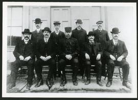
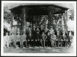
Army & Navy Imperial and Colonial Veteran's Association
A photograph of the Army & Navy Imperial & Colonbial Veteran's Association, taken in 1901.
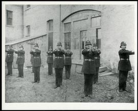
Winnipeg Police with outstretched arms
A photograph of Winnipeg Policeman standing outside of a building.
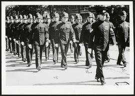
A photograph of the Winnipeg Policeman marchin, taken 1936.
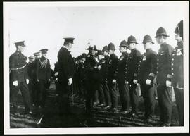
Group photo of Winnipeg Police
A photograph of Winnipeg Police officers, taken ca. 1913.
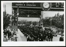
Police on Osborne Street Bridge during 1935 parade
A photograph of a parade on Osborne Street Bridge, taken 1935.
A photograph of Winnipeg Police officers.

Rossmere Shopping Centre panorama
View of Rossmere Shopping Centre, 1070 Henderson Highway, southwest corner Rowandale, 4.25 acres. From left to right: a garage or car wash, Red River Co-Op Store, Rossmere Lanes Bowling Alley, Library, Dry Cleaners, Co-operators Credit Union Society Limited, Rowandale Baptist Church, Rowandale Apartments, Red River Co-Op Gas Station. Consists of 3 separate photographs pasted together on cardboard to create a panorama. The cardboard is a scrap made from an old sign of the Metropolitan Corporation of Greater Winnipeg (visible on the reverse). The cardboard is numbered “2”, presumably as part of a compilation with other shopping centre panoramas.
Metropolitan Corporation of Greater Winnipeg (Man.). Planning Division

Southgate Shopping Centre panorama
View of Southgate Village Shopping Centre, 1305-1341 Pembina Highway at the southwest corner of McGillivray Boulevard, 3.3 acres. From left to right: Pembina Curling Rink, Imperial Cleaners, Safeway, The Place, Young Togs, Reid Marshall Pharmacy, The Village Gift Shop, The French Salon, Marshall Wells, The Toronto Dominion Bank, Safeway gas bar. Consists of 3 separate photographs pasted together on cardboard to create a panorama. The cardboard is a scrap made from an old sign of the Metropolitan Corporation of Greater Winnipeg (visible on the reverse). The cardboard is numbered “7”, presumably as part of a compilation with other shopping centre panoramas.
Metropolitan Corporation of Greater Winnipeg (Man.). Planning Division

Westwood Shopping Centre panorama
View of Westwood Shopping Centre, 3276-3332 Portage Avenue, 10.2 acres. From left to right: various shops, motel, various shops and Assiniboia Public Library, Safeway Store, Marshall Wells, Perths, Westwood Pharmacy, various Shops, Zeller's County Fair, Auto Centre. Consists of 3 separate photographs pasted together on cardboard to create a panorama. The cardboard is a scrap made from an old sign of the Metropolitan Corporation of Greater Winnipeg (visible on the reverse). The cardboard is numbered “10”, presumably as part of a compilation with other shopping centre panoramas.
Metropolitan Corporation of Greater Winnipeg (Man.). Planning Division

Aerial view of Riverview, St. Vital, and Wildwood
Aerial view of the Riverview area of Fort Rouge, including Osborne Street; the Wildwood area of Fort Garry; and the Kingston Crescent, Elm Park, Varennes, St. George, and Glenlawn areas of St. Vital, including Kingston Row, St. Mary’s Road, and St. Anne’s Road.

Arthur and Fred Landen photograph album – page 26
Page 26 of a photograph album created by brothers Arthur and Fred Landen of Hull, England. Page consists of 6 photographs taken by Fred Landen depicting, clockwise from top-left: Winnipeg’s second City Hall and the Volunteer Monument (which is captioned “Scott’s Monument, Fish Creek”); the Osborne Bridge over the Assiniboine River; a horse drawn sleigh carrying cords of wood in front of City Hall; a large house on Broadway, a dog sleigh in front of H. Laffrezen's Central Bakery at 333 1/2 William Avenue; and floating ice on the Assiniboine River.
Landen, Frederick Cluett