
- p00308
- Part
- [ca. 1920]
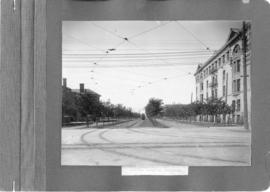
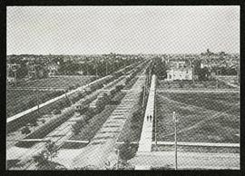
A photograph of streetcar on Broadway, looking west from Main Street. The Manitoba Club building can be seen on the left. Photographed by Steele and Company.
A photograph of streetcar on Broadway, looking west from Main Street. The Manitoba Club building can be seen on the left. Photographed by Steele and Company.

A photograph of the Portage Avenue underpass, which crosses Century Street on the north side of the St. James Bridge. The photographer is unknown.
Metropolitan Corporation of Greater Winnipeg (Man.). Information Officer
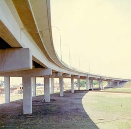
A colour photograph of the Nairn Overpass from below.
Metropolitan Corporation of Greater Winnipeg (Man.). Information Officer
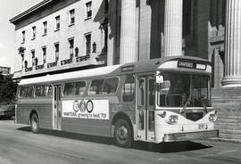
First Western Flyer bus in front of Legislature
Photograph of the first Western Flyer bus used in Winnipeg, parked in front of the Manitoba Legislature Building. The bus is chartered and bears an advertisement on its side for Manitoba's centennial. Publishing information is on the reverse. Unknown photographer.
Metropolitan Corporation of Greater Winnipeg (Man.). Information Officer
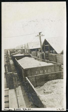
Cars hauling gravel material at Union Stock Yards
Part of Morris Block collection
Block, Morris
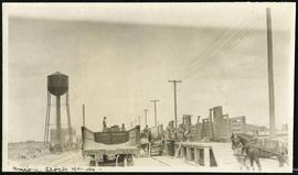
Work being done near water tower at Union Stock Yards
Part of Morris Block collection
Block, Morris
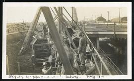
Laying 36” pipe under CPR subway
Part of Morris Block collection
Block, Morris
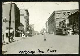
Portage looking east from around Carlton
Part of Morris Block collection
Photograph of a woman crossing Portage Avenue, looking east from around Carlton Street. The Eaton’s building can be seen on the right.
Block, Morris
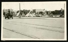
Part of Morris Block collection
Photograph of a pile of collapsed advertisement signs on an otherwise empty lot.
Block, Morris
Broadway looking west from Fort Garry Court
Part of Morris Block collection
Photograph taken from Fort Garry Court, located at Broadway and Main Street, looking west down Broadway. St. Mary’s Academy, the Parliament Building (Legislature), and Law Courts are labeled off in the distance.
Block, Morris
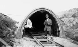
Chief Engineer Chace in aqueduct arch
Photograph of William G. Chace, Chief Engineer of the Winnipeg Aqueduct, standing in front of a completed aqueduct arch east of Brokenhead River. Photographer is unknown.
Greater Winnipeg Water District

Mixer site next to GWWD rail siding east of East Braintree
Photograph of a mixer site opposite Greater Winnipeg Water District siding rail line number 8, east of East Braintree, Manitoba. Photographer is unknown.
Greater Winnipeg Water District
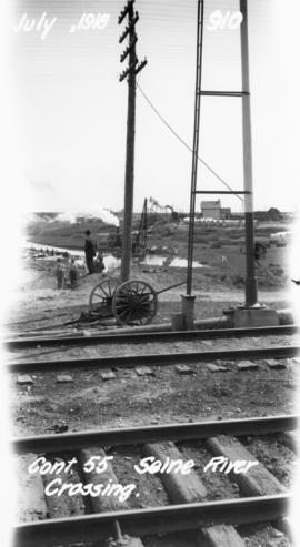
Photograph of the Seine River crossing of the Winnipeg Aqueduct, taken from the Canadian Northern Railway tracks north of Provencher Boulevard and looking northeast towards Rue Notre Dame. Photographer is unknown.
Greater Winnipeg Water District

Scrapbook of Corporal Wallace – page 2
Page 2 of a photograph scrapbook made by Corporal John Wallace in April 1940. Photos consist of Portage Avenue looking west from around Vaughn Street, a rail line at Portage Avenue and St. James Street, troops in formation, and Mrs. and Shirley Gardiner. See general notes section for more details.
Wallace, John

Winnipeg Electric Co. trolley bus
Photograph shows people waiting to board electric trolley bus (Winnipeg Electric Company), southbound Garry Street at Portage Avenue. Destination sign reads, No. 73 Sargent, Valour Road. Lindsay Building in background.

Storefronts on Portage Avenue between Carlton and Hargrave Streets
Cars and shoppers in front of stores on the north side of Portage Avenue, between Carlton and Hargrave Streets. Featured are The Berryhill Shoe Store in the Enderton / Mitchell-Copp Building, the Bank of Montreal, and Zeller's (Zellers).

Portage Avenue looking west from Colony Street
A view of Portage Avenue looking west from Colony Street. The Hudson's Bay Company Building is featured prominantly and the Power Building is visible farther west. Playing "Young Mr. Lincoln", the Gaiety Theatre can be seen across the street with two poli

Northdale Shopping Centre panorama
View of Northdale Shopping Centre, 963 Henderson Highway, 7.65 acres. From left to right: Loblaws Groceteria, Zeller's County Fair, various shops, the Royal Bank, the Canadian Imperial Bank of Commerce, A & P Food Store, Lord Wolseley School. Consists of 3 separate photographs pasted together on cardboard to create a panorama. The cardboard is a scrap made from an old sign of the Metropolitan Corporation of Greater Winnipeg (visible on the reverse). The cardboard is numbered “1”, presumably as part of a compilation with other shopping centre panoramas.
Metropolitan Corporation of Greater Winnipeg (Man.). Planning Division

Crossroads Shopping Centre panorama
View of Crossroads Shopping Centre, 1580 Regent Avenue W., 18 acres. From left to right: Woolco Department Store, Various shops, Safeway, Pacific 66 Gas Bar. Consists of 3 separate photographs pasted together on cardboard to create a panorama. The cardboard is a scrap made from an old sign of the Metropolitan Corporation of Greater Winnipeg (visible on the reverse). The cardboard is numbered “3”, presumably as part of a compilation with other shopping centre panoramas.
Metropolitan Corporation of Greater Winnipeg (Man.). Planning Division

Clark’s Department Store at Highway 59 panorama
View of Clarks at Highway 59, southwest corner of Panet Road and Nairn Avenue, 8.5 acres. From left to right: B/A gas bar, Loblaws, Clarks Discount Store and Auto Centre, B/A gas bar, Kavanaugh's Hamburgers. Consists of 3 separate photographs pasted together on cardboard to create a panorama. The cardboard is a scrap made from an old sign of the Metropolitan Corporation of Greater Winnipeg (visible on the reverse). The cardboard is numbered “4”, presumably as part of a compilation with other shopping centre panoramas.
Metropolitan Corporation of Greater Winnipeg (Man.). Planning Division