
William Smaill Photo Album – Page 96
- p00214
- Part
- [1914 or 1915]
Part of William Smaill fonds
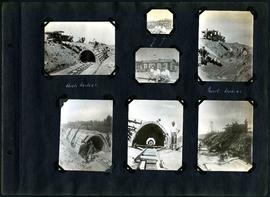
Captions read: Arch, mile 65 - Harold, Monty - Invert, mile 65.
Smaill, William
351 results with digital objects Show results with digital objects
William Smaill Photo Album – Page 96
Part of William Smaill fonds
Captions read: Arch, mile 65 - Harold, Monty - Invert, mile 65.
Smaill, William

William Smaill Photo Album – loose page
Part of William Smaill fonds
Captions read: Water tank, Indian Bay, Greater Winnipeg Water District.
Smaill, William
Winnipeg Aqueduct arch forms near Spruce Siding
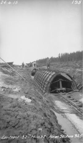
Photograph of forms for arch sections three and five of the Winnipeg Aqueduct near Spruce Siding, Manitoba. Photograph taken by William G. Chace, Chief Engineer of the Winnipeg Aqueduct.
Greater Winnipeg Water District

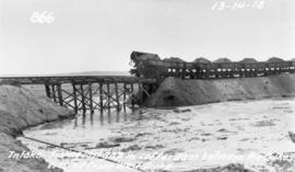
Aqueduct siphon at Birch River crossing
Photograph of a Winnipeg Aqueduct siphon at the Birch River crossing near McMunn, Manitoba. Photographer is unknown.
Greater Winnipeg Water District
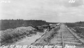
Pumping water from trench near Spruce Siding
Photograph of water being pumped from a trench next to the Greater Winnipeg Water District Railway near Spruce Siding, Manitoba, looking southeast. Photographer is unknown.
Greater Winnipeg Water District
Part of William Smaill fonds
Item consists of a photo album created by William Smaill, Superintendent of the Winnipeg Aqueduct Construction Company, Ltd. The album contains photographs of the aqueduct’s construction, company men and their families, recreation, camps and homes used during construction, the Greater Winnipeg Water District Railway, and the surrounding landscape (Shoal Lake, Whitemouth River, Indian Bay, Birch River). There are also several photos of Winnipeg during Decoration Day 1914, photos of Mayors T.R. Deacon, Thomas Sharpe, and R.D. Waugh, and two photos of an Anishinaabe camp at Kekekoziibii Shoal Lake 40 First Nation.
The photos are heavily annotated. The annotations consist of names, locations, descriptions, and sometimes the section or specific mile of the aqueduct. A few photos appear to be missing and there are several loose pages with similar content. The photos are arranged somewhat chronologically – photos from 1914 generally precede photos from 1915 – but there are many exceptions.
Smaill, William

Foot of Water Street, C.N.R. Bridge - the Flood
Photograph is one of five photos mounted on page with caption "Assiniboine River flooded, Spring 1916."

Photograph is one of five photos mounted on page with caption "Assiniboine River flooded, Spring 1916."
Fonds consists of a photo album created by William Smaill, Superintendent of the Winnipeg Aqueduct Construction Company, Ltd. The album contains photographs of the aqueduct’s construction, company men and their families, recreation, camps and homes used during construction, the Greater Winnipeg Water District Railway, and the surrounding landscape (Shoal Lake, Whitemouth River, Indian Bay, Birch River). There are also several photos of Winnipeg during Decoration Day 1914, photos of Mayors T.R. Deacon, Thomas Sharpe, and R.D. Waugh, and two photos of an Anishinaabe camp at Kekekoziibii Shoal Lake 40 First Nation.
The photos are heavily annotated. The annotations consist of names, locations, descriptions, and sometimes the section or specific mile of the aqueduct. A few photos appear to be missing and there are several loose pages with similar content. The photos are arranged somewhat chronologically – photos from 1914 generally precede photos from 1915 – but there are many exceptions.
Smaill, William

Mixer site next to GWWD rail siding east of East Braintree
Photograph of a mixer site opposite Greater Winnipeg Water District siding rail line number 8, east of East Braintree, Manitoba. Photographer is unknown.
Greater Winnipeg Water District
Filling in cofferdam for aqueduct's intake at Indian Bay
Photograph of dump cars filling in last gap of a cofferdam between dykes at the intake of the Winnipeg Aqueduct at Indian Bay, taken from the west dyke. Photographer is unknown.
Greater Winnipeg Water District

Clearing debris for aqueduct west of Snake Lake
Photograph of workers clearing debris between pole piling for the Winnipeg Aqueduct west of Snake Lake. Photographer is unknown.
Greater Winnipeg Water District
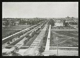
Broadway looking west from Fort Garry Court
Part of Morris Block collection
Photograph taken from Fort Garry Court, located at Broadway and Main Street, looking west down Broadway. St. Mary’s Academy, the Parliament Building (Legislature), and Law Courts are labeled off in the distance.
Block, Morris
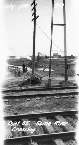
Photograph of the Seine River crossing of the Winnipeg Aqueduct, taken from the Canadian Northern Railway tracks north of Provencher Boulevard and looking northeast towards Rue Notre Dame. Photographer is unknown.
Greater Winnipeg Water District
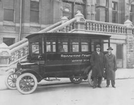
Osborne bridge - toboggan slide, Winnipeg, Winter 1918
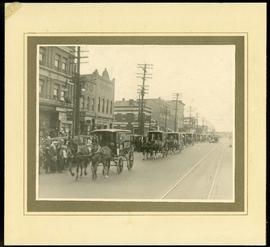
Canada Bread delivery wagons at Main and Selkirk
Part of Morris Block collection
Photograph mounted on cardboard of a cavalcade of Canada Bread horse-drawn delivery wagons riding south down Main Street, at the corner of Selkirk Avenue.
Block, Morris

Crane and David, Bakers and Confectioners
Staff standing in front of Crane and David Bakers and Confectioners at 765 Dufferin Avenue and a horse-drawn delivery cart.
Date of photograph is approximate, ca. 1920.
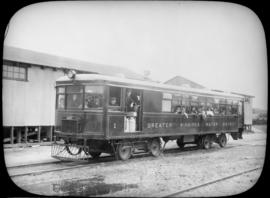
Passengers aboard GWWD Railway Service car at St. Boniface Station
Passengers aboard GWWD Railway Service car at St. Boniface Station. Image derived from glass lantern slide.
Greater Winnipeg Water District
L.B. Foote photos of GWWD Railway at St. Boniface
Glass lantern slides taken by L.B. [Lewis Benjamin] Foote of the Greater Winnipeg Water District railway and passengers in St. Boniface. The Greater Winnipeg Water District hired Foote to take these photos.
Greater Winnipeg Water District