
- i04757
- Item
- [ca. 2015]
Part of The W.R.E.N.C.H. Winnipeg Cycling Archive collection
The W.R.E.N.C.H.
Part of The W.R.E.N.C.H. Winnipeg Cycling Archive collection
The W.R.E.N.C.H.
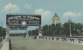
Entrance to Winnipeg and Parliament Buildings
Postcard shows Osborne Street bridge, looking north. Sign over bridge says, "Welcome to Winnipeg, The Electrical City. City Hydro, Owned and Operated by its Citizens". Date of postcard is approximate, ca. 1940.

Part of City of Winnipeg (1874-1971)
A photograph of flooding in a residential area of Winnipeg during the 1950 flood. The photograph was taken at the intersection of Disraeli and Euclid.
Harold K. White Studio

Part of Morris Block collection
Photograph of a family standing on a platform or rail cart on rail tracks.
Block, Morris
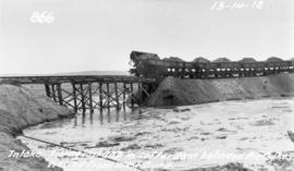
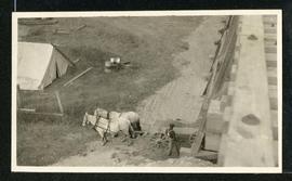
Filling in cofferdam for aqueduct's intake at Indian Bay
Photograph of dump cars filling in last gap of a cofferdam between dykes at the intake of the Winnipeg Aqueduct at Indian Bay, taken from the west dyke. Photographer is unknown.
Greater Winnipeg Water District
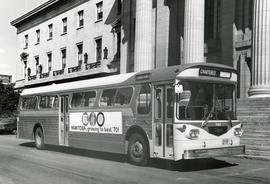
First Western Flyer bus in front of Legislature
Photograph of the first Western Flyer bus used in Winnipeg, parked in front of the Manitoba Legislature Building. The bus is chartered and bears an advertisement on its side for Manitoba's centennial. Publishing information is on the reverse. Unknown photographer.
Metropolitan Corporation of Greater Winnipeg (Man.). Information Officer

Foot of Robert Street (Galt Ave)
Part of City of Winnipeg (1874-1971)
A photograph of the Eaton's printing plant and warehouse on Robert Street (Galt Avenue) during the 1950 flood. The building is surrounded by a sandbag dike and water.
Harold K. White Studio

Foot of Water Street, C.N.R. Bridge - the Flood
Photograph is one of five photos mounted on page with caption "Assiniboine River flooded, Spring 1916."
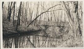
Photograph shows footbridge in wooded area, taken during the fall season. One of three photos mounted on page with caption "Scenes - Kildonan Park." Date of photograph is probable, [1923?].

Footbridge in La Barriere Park
Photograph of a footbridge across the La Salle River in La Barriere Park. A description of the photo used for publication is recorded on a separate piece of paper. Photo's reverse is stamped by the Parks and Protection Division of the Metro Government.
Metropolitan Corporation of Greater Winnipeg (Man.). Information Officer

Footbridge over Assiniboine River to City Park, Sunday afternoon
Date of photograph is approximate, ca. 1914.

For Your Guidance While in Winnipeg promotional map
Part of Morris Block collection
A promotional map created by the Publicity Bureau of Winnipeg and Manitoba titled "For Your Guidance While in Winnipeg". Map was originally folded as a pamphlet, the front page of which features a graphic of two people driving down Highway 14 (now Highway 75) to Winnipeg. The map is not scale and features cartoon depictions of tourist destinations and landmarks around Winnipeg and St. Boniface. The maps shows major streets, railroads, and street railway lines. The map side was originally framed and cut to fit. At a result a small part of the front page is cut off, including a stamp reading "St. Raphael's Ukrainian Immigrants' Welfare Association of Can[ada]".
Block, Morris
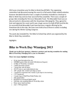
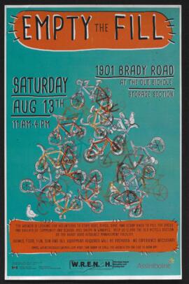
General info for BTWD 2013.docx
Part of The W.R.E.N.C.H. Winnipeg Cycling Archive collection
Bike to Work Day Winnipeg

Grant Plaza Shopping Centre panorama
View of Grant Park Plaza Shopping Centre, 1200-1216 Grant Avenue, 13.2 acres. From left to right: Clarks Discount Store, Dominion Store, Liquor Commission, Clarks Auto Centre. Consists of 3 separate photographs pasted together on cardboard to create a panorama. The cardboard is a scrap made from an old sign of the Metropolitan Corporation of Greater Winnipeg (visible on the reverse). The cardboard is numbered “8”, presumably as part of a compilation with other shopping centre panoramas.
Metropolitan Corporation of Greater Winnipeg (Man.). Planning Division
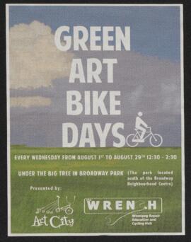
Part of The W.R.E.N.C.H. Winnipeg Cycling Archive collection
The W.R.E.N.C.H.
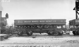
GWWD dump car at McCorkell Pit
Photograph of the side of a Greater Winnipeg Water District 20 cubic yard dump car at the McCorkell Pit, west of Ostenfeld, Manitoba. Photographer is unknown.
Greater Winnipeg Water District

Part of City of Winnipeg (1874-1971)
A photograph of Higgins Avenue during the 1950 flood. A bridge over the swollen Red River can also be seen.
Harold K. White Studio

Part of City of Winnipeg (1874-1971)
A photograph of children on Higgins Avenue during the 1950 flood. Piles of earth and sandbags line the street.
Harold K. White Studio

Part of City of Winnipeg (1874-1971)
A photograph of a flooded underpass on Higgins Avenue during the 1950 flood.
Harold K. White Studio
Part of Morris Block collection
Block, Morris