
- d00905
- [ca. 1962]-1974
Photographs of various pumping stations throughout Winnipeg.
158 results with digital objects Show results with digital objects
Photographs of various pumping stations throughout Winnipeg.
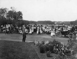
Photographs of beautification efforts on Provencher Boulevard.

Photograph shows playground staff.
Playground Sports Day at Assiniboine Park
Photograph shows playground sports day at Assiniboine Park.
Playground Programs - Pet Shows
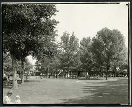
Families enjoying a playground in Elmwood Park.
Photographs of playground equipment in Winnipeg Parks.

Plan of University section of Tuxedo Park
A map of the proposed Tuxedo Park residential suburb, specifically the area surrounding the old University of Manitoba campus and Olmsted and Assiniboine Parks. The map shows streets and lots as well as details of the university campus. The map was created by Charles Clifton Chataway (1869-1920) and Bulman Brothers Ltd.
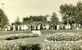
Photograph shows people gathered near a flower garden at Pembina Park (now known as Fisher Park). Date of photograph is 1938.
Parks and Recreation Photograph collection
Collection consists of circa 7000 images (photographs, slides/negatives and Polaroids) that capture views of major parks, local playgrounds, golf courses, community club grounds and recreational activities over the whole of the City.
Parks and playgrounds – general
A photograph album page with a group of children near a swingset posing on the first side. The second side depicts a group of youths and adults posing outdoors in the winter on the second side.
![Parks and Playgrounds - General [Greenway School No.1]](/uploads/r/city-of-winnipeg-archives-amp-records-control-branch/6/6/b/66b37eeaa476897febf9986d6fe99723e68f1da41085f773fb292c92f6c133ce/C0008_0001_0000_A0056_0044_001_142.jpg)
Parks and Playgrounds - General [Greenway School No.1]
A page from a photograph album. Photographs show girls playing a game at a playground (top left), children playing on a school playground slide (top right), and a girl swinging a baseball bat while other children watch (bottom). Date of photographs is approximate, [ca. 1920].
![Parks and Playgrounds - General [Greenway School No.1]](/uploads/r/city-of-winnipeg-archives-amp-records-control-branch/b/3/4/b34046418918de050940ae205eb78e0897287dd3dda334c96f28092c41f83ba3/C0008_0001_0000_A0056_0044_002_142.jpg)
Parks and Playgrounds - General [Greenway School No.1]
A page from a photograph album. Photographs show boys dancing on an outdoor dance floor (top), children posing at a playground (bottom left), and children playing volleyball at a school playground on the first side (bottom right). Date of photographs is approximate, [ca. 1920].
![Parks and Playgrounds - General [Greenway School No. 1]](/uploads/r/city-of-winnipeg-archives-amp-records-control-branch/2/f/7/2f785ef0896bef42aa5219d8fcb92941d32ea2707d5b428b4c567919a8928197/C0008_0001_0000_A0056_0036_001_142.jpg)
Parks and Playgrounds - General [Greenway School No. 1]
A page from a photograph album. 4 photographs show children playing baseball (top left), children playing ring-around-the-rosy (top right), children playing baseball (bottom left), and girls playing volleyball in a school yard (bottom right). Date of photographs is approximate, [ca. 1920].
Parks and Playgrounds - General
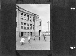
Photograph shows children playing on rope swing in a school playground. Date of photograph is approximate, [ca. 1920].
Series consists of photographs of various parks around Winnipeg.