
- i00573
- Item
- 1950
Part of City of Winnipeg (1874-1971)
A photograph taken during the 1950 flood, showing 46 Notre Dame East. Item is 2 of 6 photographs on page 55 of scrapbook.
Harold K. White Studio
77 results with digital objects Show results with digital objects
Part of City of Winnipeg (1874-1971)
A photograph taken during the 1950 flood, showing 46 Notre Dame East. Item is 2 of 6 photographs on page 55 of scrapbook.
Harold K. White Studio
Part of City of Winnipeg (1874-1971)
A photograph taken during the 1950 flood, showing 30 Notre Dame East. Item is 1 of 6 photographs on page 55 of scrapbook.
Harold K. White Studio
Scrapbook [1950 flood photographs]
Part of City of Winnipeg (1874-1971)
Subseries consists of a scrapbook assembled by the City Engineering Department to serve as photographic evidence of the 1950 flood. It contains black and white photographs that mostly document flooding in residential areas near the Red River (Fort Rouge, Riverview, North End, Point Douglas, Crescentwood, Armstrong's Point and others). Scrapbook appears to be organized geographically by area and street. In addition to documenting flooding, the photographs provide a detailed record of residential neighbourhoods, houses, streets, and businesses like corner grocery stores and laundries. All photographs were taken by Harold K. White Studio.
Winnipeg (Man.). City Engineer
Part of City of Winnipeg (1874-1971)
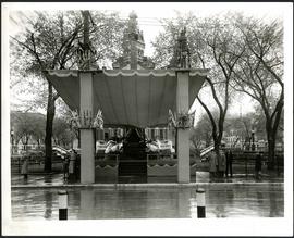
A photograph of a stage in front of City Hall, built for the visit to Winnipeg of Their Majesties King George VI and Queen Elizabeth on May 24, 1939.
Winnipeg (Man.). Committee on Legislation and Reception
City Hall decorated for coronation
Part of City of Winnipeg (1874-1971)
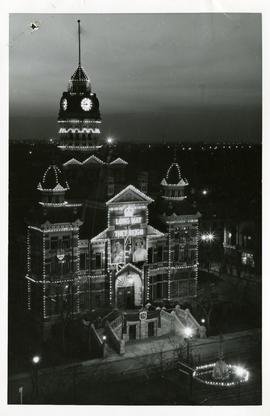
A photograph of City Hall decorated for the coronation of King George VI and Queen Elizabeth that took place on May 12, 1937. Sign reads, "LONG MAY THEY REIGN."
Winnipeg (Man.). Committee on Legislation and Reception

Part of City of Winnipeg (1874-1971)
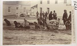
J. L. Reid's arrival from the west
Part of City of Winnipeg (1874-1971)
Dog sled shown in photograph.

Part of City of Winnipeg (1874-1971)
Ox drawn cart shown in photograph.

Pontoon Bridge, Fort Garry and Warehouse from south side Assiniboine River
Part of City of Winnipeg (1874-1971)

Main Street looking north from Portage Avenue
Part of City of Winnipeg (1874-1971)
Bentley Building, Courthouse and Artesian well shown in photograph.
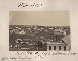
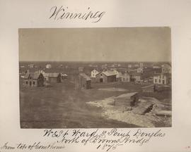
Winnipeg, East Ward, north of Browns Bridge, 1875
Part of City of Winnipeg (1874-1971)
Photograph taken from top of Courthouse.

Winnipeg, Main Street looking south, Spring of 1874
Part of City of Winnipeg (1874-1971)
Photograph taken from top of Courthouse.
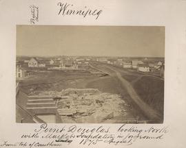
Winnipeg, West Ward, Point Douglas north of Browns Bridge, 1875
Part of City of Winnipeg (1874-1971)
Photograph taken from top of Courthouse.
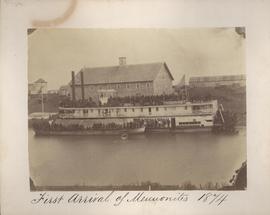
First arrival of Mennonites, 1874
Part of City of Winnipeg (1874-1971)

Winnipeg, Main Street looking south, Summer 1875
Part of City of Winnipeg (1874-1971)
Photograph taken from top of Courthouse.

Point Douglas from Courthouse, 1874
Part of City of Winnipeg (1874-1971)
Point Douglas looking north with City Hall foundation in foreground, August 1875
Part of City of Winnipeg (1874-1971)
Photograph taken from top of Courthouse.

Part of East Ward, St. Boniface in the distance
Part of City of Winnipeg (1874-1971)
Photograph taken from top of Courthouse.

Winnipeg Fire Brigade, July 1, 1875
Part of City of Winnipeg (1874-1971)

Part of City of Winnipeg (1874-1971)
Photograph of the Winnipeg Renovating Co. on Lombard Avenue. Item is part of small album containing photographs of maps tracking the outbreak of typhoid from 1905 to 1908 and other scenes. Item is loose and at back of album. Date of item is approximate, [circa 1909].