

Crane and David, Bakers and Confectioners
- i01411
- Item
- [ca. 1910]
Staff standing in front of Crane and David Bakers and Confectioners at 765 Dufferin Avenue and a horse-drawn delivery cart.
768 results with digital objects Show results with digital objects
Crane and David, Bakers and Confectioners
Staff standing in front of Crane and David Bakers and Confectioners at 765 Dufferin Avenue and a horse-drawn delivery cart.
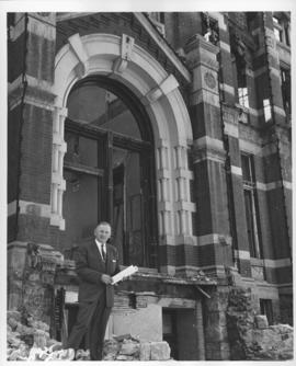
Mayor Stephen Juba standing in front of partially demolished City Hall building, April 27, 1962
Photograph shows demolition of Winnipeg's second City Hall. - Stamp (on verso): Photograph by Hugh Allan, Winnipeg Tribune, Staff Photographer.
Allan, Hugh
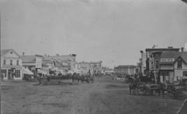
View of Main Street looking north
City of Winnipeg businesses shown in photograph: George Ashdown Hardware, Davis House, Symonds Furrier, Gable Hotel, J. Lister, Outfitter, Rossin House, the Blue Store, and the first City Hall is shown in background.

The Cove Restaurant, corner of Portage and Carlton
Photograph of "The Cove" Restaurant at 355 Portage Avenue, at Carlton Street. The photograph was taken from a building on Carlton Street looking southeast towards the Eaton's Building, Mitchell-Copp, Zeller's, and the Carlton Building.
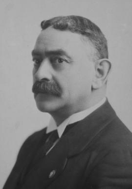
Cropped to show only Alderman Daniel McLean of Ward Three.
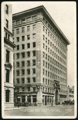
Postcard of Grain Exchange Building
Postcard featuring the Grain Exchange Building at 167 Lombard Avenue, northeast corner of Rorie Street. The postcard is captioned "The Largest Grain Market in the World".
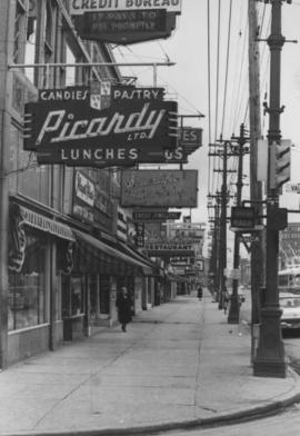
Overhanging Signs: North side of Portage Avenue looking East from Vaughan Street
Photograph shows signs for multiple businesses, including Picardy Lunches, Scientific Hairdressing, Credit Bureau. Date of photograph is uncertain, [196-?].
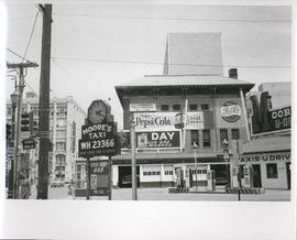
Existing Conditions, Corner of Graham and Donald looking East
A photograph of the southeast corner of Donald Street and Graham Avenue featuring a Moore's Taxi U Drive station in the foreground. Behind it in the background can be seen The Columbus Hall / Aragon Building with advertisements for Pepsi Cola and the Rainbow Dance Gardens, and the Tribune Building can be seen at the left. This is the present site of the Millennium Library. The back of the photo is marked: "Photograph 5. Existing Conditions, corner of Graham and Donald Looking East. Urban Renewal and Rehabilitation Board City of Winnipeg".
Winnipeg (Man.). Urban Renewal and Rehabilitation Board

Aerial view of Riverview, St. Vital, and Wildwood
Aerial view of the Riverview area of Fort Rouge, including Osborne Street; the Wildwood area of Fort Garry; and the Kingston Crescent, Elm Park, Varennes, St. George, and Glenlawn areas of St. Vital, including Kingston Row, St. Mary’s Road, and St. Anne’s Road.
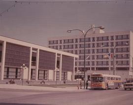
A photograph of the Civic Centre Complex, Winnipeg's third city hall (1964-present). Council Building, Administration Building, and public transit bus in view. Taken from William Avenue and Main Street, looking northwest. Date of photograph is uncertain, [197-?]. The photographer is likely Henry Kalen.
Kalen, Henry
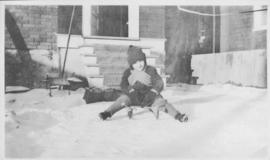
Photograph shows winter scene with child (Robert F. Gifford) sitting on sled.
1921 Winnipeg City Council Collage
Winnipeg City Council in 1921: F. O. Fowler, H. Gray, A. H. Pulford, J.K. Sparling, D. McLean, J. G. Sullivan, W. Douglas, F. H. Davidson, J. A McKerchar, Thos. Boyd, Mayor E. Parnell, G. Fisher, Mrs. J. Kirk, J. O'Hare, J. Blumberg, J. Queen, H. Jones, A. A. Heaps, W. B. Simpson

Photograph album of Winnipeg during WW1: Page 5
Item consists of a scrapbook page showing soldiers lined up in military parade in front of the Industrial Bureau Exposition Building (Item 21), soldiers lined up in military parade (Item 22),
soldiers on horse in military parade in front of the Industrial Bureau Exposition Building (Item 23), crowd forming on street in front of the Israelite Jewish Daily newspaper building (975 Main Street) and the H. Lindster's Bakery (971 Main Street). Soldiers and Police in foreground (Item 24), [ca. 1913].
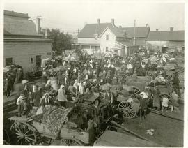
The North End market behind Dufferin Avenue and Derby Street
Carts of goods and shoppers in a bustling market around Dufferin Avenue and Derby Street in the North End.
Dyking built up around Shaarey Zedek Synagogue, 1950 Flood
Photograph taken at Shaarey Zedek Synagogue, 561 Wellington Crescent off Academy Road, on the western bank of the Assiniboine River. - Stamp (on verso): by Harold K. White Studio, 274 Fort St. Winnipeg, Phone 924 289.
Harold K. White Studio

Winnipeg’s Best Tourist Cabin Camp on Pembina Highway
Postcard featuring “Winnipeg’s Best Tourist Cabin Camp”, located on Pembina Highway (then Highway Number 14) around Chevrier Boulevard.

Winnipeg Tourist Cabins and Camp Park on Pembina Highway
Postcard featuring “Winnipeg Tourist Cabins and Camp Park”, located on Pembina Highway (then Highway Number 14) around Chevrier Boulevard.
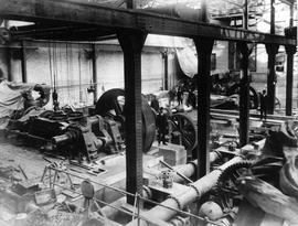
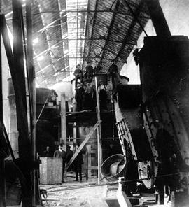
James Avenue Pumping Station – interior
Interior shot of the James Avenue Pumping Station on James Avenue and Amy Street, still under construction.
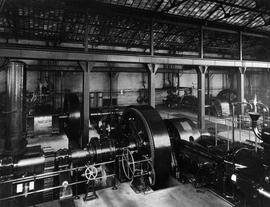
James Avenue Pumping Station – interior
Interior shot of the James Avenue Pumping Station on James Avenue and Amy Street.
James Avenue Pumping Station – interior
Interior shot of the James Avenue Pumping Station on James Avenue and Amy Street, still under construction.