
William Smaill Photo Album – Page 94
- p00212
- Part
- 1915
Part of William Smaill fonds
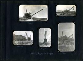
Captions read: Camp 2 - Camp 3 - Camp 3 - Camp 2 - Camp 2 - Moving dragline to backfill, 1915.
Smaill, William
William Smaill Photo Album – Page 94
Part of William Smaill fonds
Captions read: Camp 2 - Camp 3 - Camp 3 - Camp 2 - Camp 2 - Moving dragline to backfill, 1915.
Smaill, William
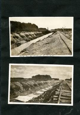
William Smaill Photo Album – loose page
Part of William Smaill fonds
Captions read: Tube partly covered, Greater Winnipeg Water District.
Smaill, William
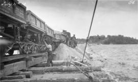
Placing material on Falcon River Diversion Dyke at Indian Bay
Photograph of workers using a scow to place material from cars onto the Falcon River Diversion Dyke at Indian Bay. Photograph taken by William G. Chace, Chief Engineer of the Winnipeg Aqueduct.
Greater Winnipeg Water District

Aqueduct siphon at Birch River crossing
Photograph of a Winnipeg Aqueduct siphon at the Birch River crossing near McMunn, Manitoba. Photographer is unknown.
Greater Winnipeg Water District
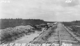
Pumping water from trench near Spruce Siding
Photograph of water being pumped from a trench next to the Greater Winnipeg Water District Railway near Spruce Siding, Manitoba, looking southeast. Photographer is unknown.
Greater Winnipeg Water District
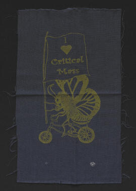
I heart Critical Mass screen print
Part of The W.R.E.N.C.H. Winnipeg Cycling Archive collection
Design adapted from a Beehive Collective art piece by Juan Martinez.
Critical Mass Winnipeg
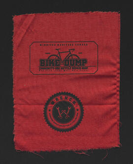
Bike Dump made with my own two hands fists logo screen print
Part of The W.R.E.N.C.H. Winnipeg Cycling Archive collection
Designed by Geoffrey Heath and Camille Metcalfe.
The Bike Dump

W.R.E.N.C.H. logo screen print
Part of The W.R.E.N.C.H. Winnipeg Cycling Archive collection
Art by David Oro.
The W.R.E.N.C.H.
Bike Dump and W.R.E.N.C.H. logos screen print
Part of The W.R.E.N.C.H. Winnipeg Cycling Archive collection
Art by David Oro.
The W.R.E.N.C.H.
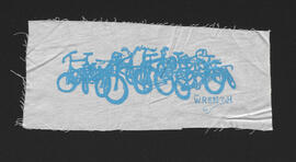
The W.R.E.N.C.H. bike pile logo screen print
Part of The W.R.E.N.C.H. Winnipeg Cycling Archive collection
Art by Laura Tait.
The W.R.E.N.C.H.
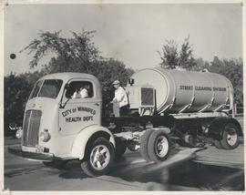
Photograph shows a street cleaning truck from the City of Winnipeg Health Department's Street Cleaining Division. Two City workers can be seen in the photograph. Date of photograph is uncertain.

Arlington Bridge from top of chimney
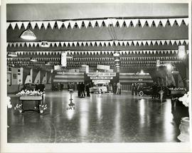
A car show likely held at the Civic Auditorium on Vaughan Street. Several cars are on display from brands such as Hudson and Austin.
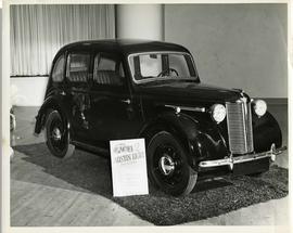
Austin Eight Saloon at car show
An Austin Eight Saloon model car at a car show likely held in the Civic Auditorium on Vaughan Street.
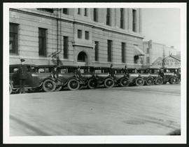
Police cars outside Rupert Avenue Police Station
A photograph of the Police Station and police car fleet on Rupert Avenue, taken ca. 1930.
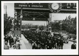
Police on Osborne Street Bridge during 1935 parade
A photograph of a parade on Osborne Street Bridge, taken 1935.

Rossmere Shopping Centre panorama
View of Rossmere Shopping Centre, 1070 Henderson Highway, southwest corner Rowandale, 4.25 acres. From left to right: a garage or car wash, Red River Co-Op Store, Rossmere Lanes Bowling Alley, Library, Dry Cleaners, Co-operators Credit Union Society Limited, Rowandale Baptist Church, Rowandale Apartments, Red River Co-Op Gas Station. Consists of 3 separate photographs pasted together on cardboard to create a panorama. The cardboard is a scrap made from an old sign of the Metropolitan Corporation of Greater Winnipeg (visible on the reverse). The cardboard is numbered “2”, presumably as part of a compilation with other shopping centre panoramas.
Metropolitan Corporation of Greater Winnipeg (Man.). Planning Division

Southgate Shopping Centre panorama
View of Southgate Village Shopping Centre, 1305-1341 Pembina Highway at the southwest corner of McGillivray Boulevard, 3.3 acres. From left to right: Pembina Curling Rink, Imperial Cleaners, Safeway, The Place, Young Togs, Reid Marshall Pharmacy, The Village Gift Shop, The French Salon, Marshall Wells, The Toronto Dominion Bank, Safeway gas bar. Consists of 3 separate photographs pasted together on cardboard to create a panorama. The cardboard is a scrap made from an old sign of the Metropolitan Corporation of Greater Winnipeg (visible on the reverse). The cardboard is numbered “7”, presumably as part of a compilation with other shopping centre panoramas.
Metropolitan Corporation of Greater Winnipeg (Man.). Planning Division

Westwood Shopping Centre panorama
View of Westwood Shopping Centre, 3276-3332 Portage Avenue, 10.2 acres. From left to right: various shops, motel, various shops and Assiniboia Public Library, Safeway Store, Marshall Wells, Perths, Westwood Pharmacy, various Shops, Zeller's County Fair, Auto Centre. Consists of 3 separate photographs pasted together on cardboard to create a panorama. The cardboard is a scrap made from an old sign of the Metropolitan Corporation of Greater Winnipeg (visible on the reverse). The cardboard is numbered “10”, presumably as part of a compilation with other shopping centre panoramas.
Metropolitan Corporation of Greater Winnipeg (Man.). Planning Division

Arthur and Fred Landen photograph album – page 26
Page 26 of a photograph album created by brothers Arthur and Fred Landen of Hull, England. Page consists of 6 photographs taken by Fred Landen depicting, clockwise from top-left: Winnipeg’s second City Hall and the Volunteer Monument (which is captioned “Scott’s Monument, Fish Creek”); the Osborne Bridge over the Assiniboine River; a horse drawn sleigh carrying cords of wood in front of City Hall; a large house on Broadway, a dog sleigh in front of H. Laffrezen's Central Bakery at 333 1/2 William Avenue; and floating ice on the Assiniboine River.
Landen, Frederick Cluett