

- i03467
- Item
- [1967?]
A photograph of the Portage Avenue underpass, which crosses Century Street on the north side of the St. James Bridge. The photographer is unknown.
Metropolitan Corporation of Greater Winnipeg (Man.). Information Officer
135 results with digital objects Show results with digital objects
A photograph of the Portage Avenue underpass, which crosses Century Street on the north side of the St. James Bridge. The photographer is unknown.
Metropolitan Corporation of Greater Winnipeg (Man.). Information Officer
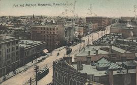

Postcard shows Portage Avenue, from Main Street looking west. Published by Valentine & Sons' Publishing Co., Ltd. Montreal and Toronto. Printed in Great Britain. Date of postcarcd is uncertain.
Portage Avenue, Winnipeg, Man.
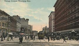
Postcard shows view from Portage Avenue and Hargrave Street. The T. Eaton Co. Ltd. department store is shown at right; Clarendon Hotel is shown at left. Date of postcard is uncertain, [before 1949].
Portage Avenue, Winnipeg, Manitoba
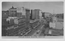
Photograph shows view of Paris and Avenue buildings and Bank of Nova Scotia building. Date of photograph is approximate, ca. 1940.

Pumping water on Robert Street
Part of City of Winnipeg (1874-1971)
A photograph of a pipe pouring water onto tracks on Robert Street (Galt Avenue) during the 1950 flood. A pile of wood is along one side of the street. The Ogilvie Flour Mill can be seen in the background.
Harold K. White Studio
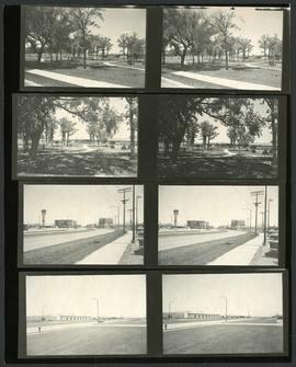
Scenes from around St. James and the St. James Bridge
Consists of several photos of the area around the St. James Bridge and includes small parks and green spaces, and the St. James Shopping Centre on Portage Avenue near Moray Street. Photographer is unknown.
Metropolitan Corporation of Greater Winnipeg (Man.). Information Officer
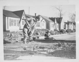
Screed - Inkster Boulevard, east of McKenzie Street
Item consists of a photograph showing construction of concrete road.

Screeds, new concrete road, Inkster, east of McKenzie
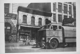
Sicard Flusher, Market Street - May 1948
Star Hotel, Market Café, Dirkfield's Novelty Mfg. shown in background of photograph.
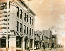
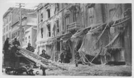
South West Corner of King and William
Item is a photographic reproduction, date unknown (original created ca. 1900). Shows the south west corner of King Street and William Avenue.

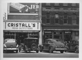
Southeast corner of back lane, north side of Market Avenue and Main Street, circa 1941
Photograph shows present site of the Centennial Concert Hall. Cristall's Mens Outfitters and Klasser's Mail Order House visible in photograph.
Southeast corner of back lane, north side of Market Avenue and Main Street, circa 1941
Photograph shows present site of the Centennial Concert Hall. Cristall's Mens Outfitters visible in photograph.

The Cove Restaurant, corner of Portage and Carlton
Photograph of "The Cove" Restaurant at 355 Portage Avenue, at Carlton Street. The photograph was taken from a building on Carlton Street looking southeast towards the Eaton's Building, Mitchell-Copp, Zeller's, and the Carlton Building.
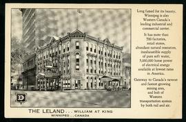
The Leland Hotel, William at King
Postcard shows Leland Hotel at William Avenue and King Street. Date of postcard is uncertain [before 1949].

Thoroughfares: Academy Road at Wellington Crescent
View of cars and cyclists heading down Academy Road towards Wellington Crescent and the Maryland Bridge. The cupola of Misericordia Hospital can be seen across the bridge.

Thoroughfares: Academy Road at Wellington Crescent
View of cars and cyclists heading down Academy Road towards Wellington Crescent and the Maryland Bridge. A small portion of Misericordia Hospital can be seen across the bridge.
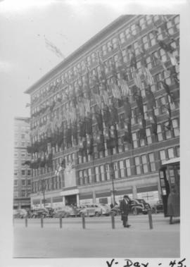
VE Day in Winnipeg showing Eaton's Building on Portage Avenue adorned with flags
Photograph shows Victory in Europe Day (VE Day) celebrations marking the end of World War 2 in Europe.
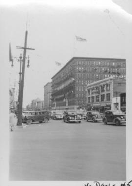
VE Day in Winnipeg showing Portage Avenue and Eaton's building in background
Photograph shows Victory in Europe Day (VE Day) celebrations marking the end of World War 2 in Europe.