

- i04576
- Pièce
- 11 Feb. 1971
Fait partie de Parks and Recreation Photograph collection
Chief Peguis Memorial in Kildonan Park.
Sans titre
267 résultats avec objets numériques Afficher les résultats avec des objets numériques
Fait partie de Parks and Recreation Photograph collection
Chief Peguis Memorial in Kildonan Park.
Sans titre
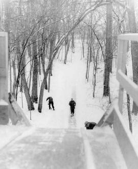
Cleaning toboggan slide in Kildonan Park
Fait partie de Parks and Recreation Photograph collection
Park workers cleaning off the toboggan slide in Kildonan Park.
Sans titre

Fait partie de Parks and Recreation Photograph collection
Kildonan Park in winter.
Sans titre

Aerial view of Bonnycastle Park
Fait partie de Parks and Recreation Photograph collection
Aerial view of an occasion at Bonnycastle Park with people gathered around a portable stage watching a performance.
Sans titre
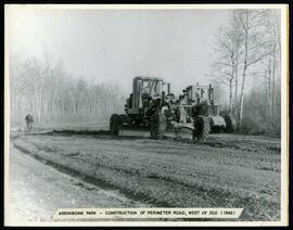
Perimeter road construction at Assiniboine Park Zoo
Fait partie de Parks and Recreation Photograph collection
Construction of perimeter road west of the Assiniboine Park Zoo.
Sans titre
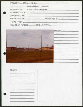
Riel Park – project development components
Fait partie de Parks and Recreation Photograph collection
Project development components form for Riel Park with a colour photograph affixed.
Sans titre
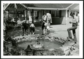
Aunt Sally's Farm at the Assiniboine Park Zoo
Fait partie de Parks and Recreation Photograph collection
Photograph of visitors enjoying a fountain at Aunt Sally's Farm, in the Assiniboine Park Zoo. Photograph was taken by Gunter A. Schoch, Landscape Architect with the Metropolitan Corporation of Greater Winnipeg's Parks and Protection Division.
Sans titre

Notre Dame Avenue facing west from Arlington Street
Fait partie de Parks and Recreation Photograph collection
View of the boulevard on Notre Dame Avenue facing west, between Arlington and McPhillips Streets. Free Press Depot Number 2 can be seen on the right.

Plan of University section of Tuxedo Park
Fait partie de Parks and Recreation Photograph collection
A map of the proposed Tuxedo Park residential suburb, specifically the area surrounding the old University of Manitoba campus and Olmsted and Assiniboine Parks. The map shows streets and lots as well as details of the university campus. The map was created by Charles Clifton Chataway (1869-1920) and Bulman Brothers Ltd.
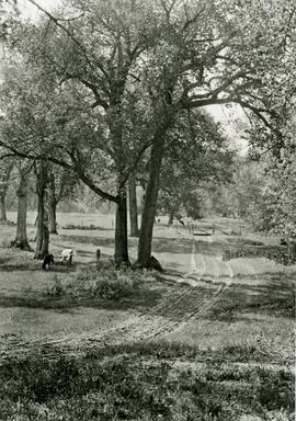
Fait partie de Parks and Recreation Photograph collection
A photograph of cows grazing in Fraser’s Grove Park in East Kildonan.
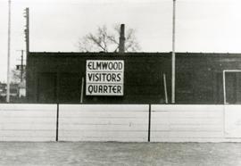
Original boxcar clubhouse at Kelvin Community Centre
Fait partie de Parks and Recreation Photograph collection
The original boxcar clubhouse at the Kelvin Community Centre with a sign reading “Elmwood Visitors Quarter”.
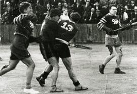
Elmwood Pats competing in lacrosse game
Fait partie de Parks and Recreation Photograph collection
Action shot of the Elmwood Pats playing lacrosse, likely at the Kelvin Community Centre.
Groundskeeper in Fort Rouge Park
Fait partie de Parks and Recreation Photograph collection
A groundskeeper tending to Fort Rouge Park.
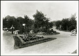
Fait partie de Parks and Recreation Photograph collection
Album page with two photographs of Central Park, one on each side. Photographs are numbered by the photographer (Steele and Company) as a861 and a861a.
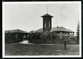
Assiniboine Park Pavilion and Annex
Fait partie de Parks and Recreation Photograph collection
A man standing in front of the Pavilion and Annex at Assiniboine Park.

New boulevards on street north from Palmerston Avenue.
Fait partie de Parks and Recreation Photograph collection
View of new boulevards on an unidentified street in the Wolseley area, facing north from Palmerston Avenue.
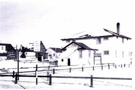
Exterior of Kelvin Community Centre
Fait partie de Parks and Recreation Photograph collection
Photograph of the exterior of the Kelvin Community Centre.
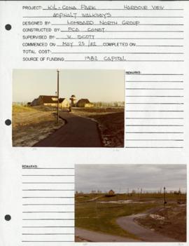
Harbourview Recreation Complex – project development components
Fait partie de Parks and Recreation Photograph collection
Project development component form for the Harbourview Recreation Complex in Kil-cona Park.
Sans titre
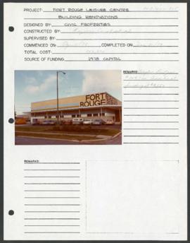
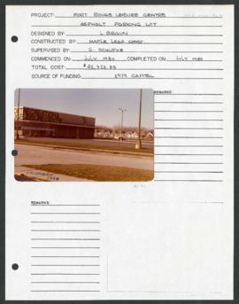
Fort Rouge Leisure Centre – project development components
Fait partie de Parks and Recreation Photograph collection
Project development component form for the Fort Rouge Leisure Center with a colour photograph attached.
Sans titre
Fort Rouge Leisure Centre – project development components
Fait partie de Parks and Recreation Photograph collection
Project development component form for the Fort Rouge Leisure Center with a colour photograph attached.
Sans titre