
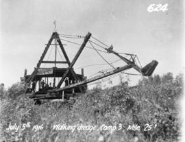
Dredge excavating for aqueduct south of Anola
- i02911
- Item
- 5 Jul. 1916
Photograph of a dredge excavating for the Winnipeg Aqueduct south of Anola, Manitoba. Photographer is unknown.
Greater Winnipeg Water District
304 results with digital objects Show results with digital objects
Dredge excavating for aqueduct south of Anola
Photograph of a dredge excavating for the Winnipeg Aqueduct south of Anola, Manitoba. Photographer is unknown.
Greater Winnipeg Water District
Photographs from the construction of Branch 1 of the Greater Winnipeg Water District aqueduct.
Greater Winnipeg Water District

Contract 65 - Mile 1.5 - View of mucking hoist dumping excavated material into dump wagon at Sta. 81+00 on Pacific Avenue, looking east toward Xante Street. Work progressed eastward from Alexander Avenue at Yeomans Street. Buildings of Western Packing C
Greater Winnipeg Water District
Contract 65 - Mile 1.5 - View of mucking hoist dumping excavated material into dump wagon at Sta. 81+00 on Pacific Avenue, looking east toward Xante Street. Work progressed eastward from Alexander Avenue at Yeomans Street. Buildings of Western Packing C
Greater Winnipeg Water District

View of men mucking trench for 48-inch diameter Branch 1 aqueduct at Sta. 169+00 on Pacific Avenue
Contract 65 - Mile 3.2 - View of men mucking trench for 48 inch diameter Branch 1 aqueduct at Sta. 169+00 on Pacific Avenue. Looking west between Louise Street and Main Street. Work progressed westward from the west tunnel shaft. Buiilding of The James
Greater Winnipeg Water District
L.B. Foote photos of GWWD Railway at St. Boniface
Glass lantern slides taken by L.B. [Lewis Benjamin] Foote of the Greater Winnipeg Water District railway and passengers in St. Boniface. The Greater Winnipeg Water District hired Foote to take these photos.
Greater Winnipeg Water District
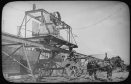
Building the Shoal Lake Aqueduct
A photograph of the building of the Shoal Lake Aqueduct. Officially opened on September 9, 1919. Item appears to be a photographic reproduction of an image dated June 24, 1915.
Part of William Smaill fonds
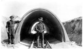
Item consists of a photo album created by William Smaill, Superintendent of the Winnipeg Aqueduct Construction Company, Ltd. The album contains photographs of the aqueduct’s construction, company men and their families, recreation, camps and homes used during construction, the Greater Winnipeg Water District Railway, and the surrounding landscape (Shoal Lake, Whitemouth River, Indian Bay, Birch River). There are also several photos of Winnipeg during Decoration Day 1914, photos of Mayors T.R. Deacon, Thomas Sharpe, and R.D. Waugh, and two photos of an Anishinaabe camp at Kekekoziibii Shoal Lake 40 First Nation.
The photos are heavily annotated. The annotations consist of names, locations, descriptions, and sometimes the section or specific mile of the aqueduct. A few photos appear to be missing and there are several loose pages with similar content. The photos are arranged somewhat chronologically – photos from 1914 generally precede photos from 1915 – but there are many exceptions.
Smaill, William
William Smaill Photo Album – Page 3
Part of William Smaill fonds
Captions read: Driving The last spike Greater Winnipeg Water District railway, Mayor Thos. R. Deacon, December 1914.
Smaill, William

William Smaill Photo Album – Page 15
Part of William Smaill fonds
Captions read: Anderson's dredge making cut between Indian Bay and Snowshoe Bay.
Smaill, William

William Smaill Photo Album – Page 17
Part of William Smaill fonds
Captions read: First bucket on aqueduct - Erection number 3 class 7 at mile 64.
Smaill, William

William Smaill Photo Album – Page 18
Part of William Smaill fonds
Captions read: Class 9 at Oguaka, Iowa - Monighan machine.
Smaill, William

William Smaill Photo Album – Page 19
Part of William Smaill fonds
Captions read: Tomlison and Pleming's camp - Ballast trains - Birch River - Clearing land, Whtiemouth - Class 14 pads - Lidgerwood - Unloading boom - Camp 5, April 14 - Work train - McLerie's - Deacon - Hand cars - Culverts, mile 57 - Hunter and Jack Cumm
Smaill, William
William Smaill Photo Album – Page 21
Part of William Smaill fonds
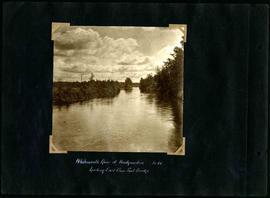
Captions read: Whitemouth River at headquarters looking east from foot bridge, mile 64.
Smaill, William
William Smaill Photo Album – Page 23
Part of William Smaill fonds
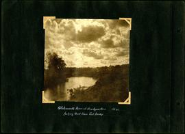
Captions read: Whitemouth River at headquarters looking west from foot bridge, Mile 64.
Smaill, William

William Smaill Photo Album – Page 24
Part of William Smaill fonds
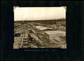
Captions read: First foundation fill, mile 71.
Smaill, William
William Smaill Photo Album – Page 26
Part of William Smaill fonds
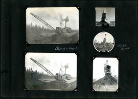
Captions read: Class 14 at camp 6 - 2 cubic yard bucket.
Smaill, William

William Smaill Photo Album – Page 33
Part of William Smaill fonds
Smaill, William

William Smaill Photo Album – Page 35
Part of William Smaill fonds
Captions read: Class 7 drag shows pads and rolls.
Smaill, William
William Smaill Photo Album – Page 47
Part of William Smaill fonds
Captions read: Protection of inverts from sun and rain, mile 51.
Smaill, William