
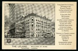
The Leland Hotel, William at King
- i01698
- Item
- [194-?]
Postcard shows Leland Hotel at William Avenue and King Street. Date of postcard is uncertain [before 1949].
The Leland Hotel, William at King
Postcard shows Leland Hotel at William Avenue and King Street. Date of postcard is uncertain [before 1949].

C.P.R. Depot and Royal Alexandra Hotel, Winnipeg, Manitoba
Photograph shows Canadian Pacific Railway depot and Royal Alexandra Hotel on Higgins Avenue. Date of photograph is approximate, ca. 1940.

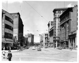
Postcard shows Portage Avenue, from Main Street looking west. Published by Valentine & Sons' Publishing Co., Ltd. Montreal and Toronto. Printed in Great Britain. Date of postcarcd is uncertain.

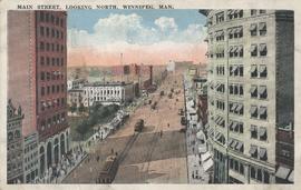
Main Street North, Winnipeg, Manitoba, Canada
Print is a photographic image of Main Street North. The McLaren Hotel, Hotel Cornwall and C.P.R. Station can be seen in photograph
Postcard shows Main Street looking north from McDermot Avenue to Union Bank Building. Date of postcard is uncertain, [before 1949].
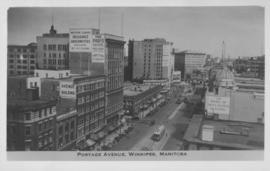
Portage Avenue, Winnipeg, Manitoba
Photograph shows view of Paris and Avenue buildings and Bank of Nova Scotia building. Date of photograph is approximate, ca. 1940.
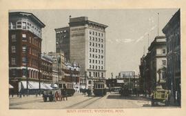
Main Street, looking north, Winnipeg, Man.
Postcard showing Main Street looking north from Bannatyne Avenue. Date of postcard is unknown.

Thoroughfares: Academy Road at Wellington Crescent
View of cars and cyclists heading down Academy Road towards Wellington Crescent and the Maryland Bridge. A small portion of Misericordia Hospital can be seen across the bridge.

Scrapbook of Corporal Wallace – page 9
Page 9 of a photograph scrapbook made by Corporal John Wallace in April 1940. Photographs depict a street in Gladstone Manitoba, a trolley bus in Winnipeg on Kennedy Street (between Ellice and Qu'Appelle), and the Butler family, acquaintances of Wallace. See page three of this scrapbook for more details on the Butler family.
Wallace, John
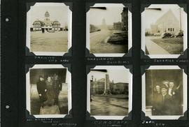
Scrapbook of Corporal Wallace – page 6
Page 6 of a photograph scrapbook made by Corporal John Wallace in April 1940. Photographs depict the Pavilion in City Park (Assiniboine Park), the Legislature Building off in the distance down Memorial Boulevard, St. Ignatius Church at Corydon Avenue and Stafford Street, the Winnipeg Cenotaph, and acquaintenances of Wallace, Mr. and Mrs. McCarthy and “Sister Sue”, and two people identified only as “Joan” and “Den”. See general notes section for more details.
Wallace, John

Scrapbook of Corporal Wallace – page 2
Page 2 of a photograph scrapbook made by Corporal John Wallace in April 1940. Photos consist of Portage Avenue looking west from around Vaughn Street, a rail line at Portage Avenue and St. James Street, troops in formation, and Mrs. and Shirley Gardiner. See general notes section for more details.
Wallace, John
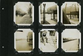
Scrapbook of Corporal Wallace – page 8
Page 8 of a photograph scrapbook made by Corporal John Wallace in April 1940. Photographs depict the Queen’s Own Cameron Highlanders of Canada near the Raleigh Apartments at Vaughan Street and Ellice Avenue, Memorial Boulevard (likely at Broadway, facing west with the Mall Hotel in the distance), a road outside Fort Osborne Barracks, and Corporal Wallace at the home of “The Dowlings” (likely on Beaverbrook Street).
Wallace, John

Notre Dame Avenue facing west from Arlington Street
View of the boulevard on Notre Dame Avenue facing west, between Arlington and McPhillips Streets. Free Press Depot Number 2 can be seen on the right.
Portage Avenue and Main Street looking north

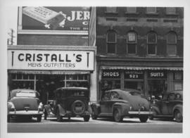
Southeast corner of back lane, north side of Market Avenue and Main Street, circa 1941
Photograph shows present site of the Centennial Concert Hall. Cristall's Mens Outfitters and Klasser's Mail Order House visible in photograph.
Southeast corner of back lane, north side of Market Avenue and Main Street, circa 1941
Photograph shows present site of the Centennial Concert Hall. Cristall's Mens Outfitters visible in photograph.
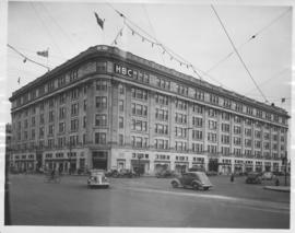
Hudson's Bay Company Store from Portage Avenue at Memorial Boulevard
Date of photograph is approximate, ca. 1942.
![Logan Avenue and Main Street [Aerial view]](/uploads/r/city-of-winnipeg-archives-amp-records-control-branch/d/9/2/d92728eee72f0ac3b14bbb8ea8f04c5d3ece08f19538ee5d078eb79492de602b/C0013_0000_0000_P0018_0034_001_142.jpg)
Logan Avenue and Main Street [Aerial view]
Inscription (on recto): A160 3-9-43 Logan Ave and Main St Wpg [Winnipeg] about 4000' 5".
![Logan Avenue and Salter Street [Aerial view]](/uploads/r/city-of-winnipeg-archives-amp-records-control-branch/9/8/0/980f8ba4214d821c9b49366ae35d9ea9ed5b7f44366c5cd894e04befdd6c7a22/C0013_0000_0000_P0018_0033_001_142.jpg)
Logan Avenue and Salter Street [Aerial view]
Inscription (on recto): A161 3-9-43 Logan Ave and Salter St Wp [Winnipeg?] about 4000' 5".
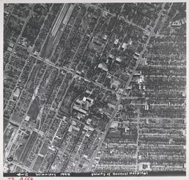
Aerial view of Vicinity of General Hospital, 1944
Description (on recto): WG A156, vicinity of General Hospital, Winnipeg, 1944. - Area around William Avenue and Sherbrook Street shown in photograph. - Photo credit: Royal Canadian Air Force Photograph.