Page 28 of a photograph album created by brothers Arthur and Fred Landen of Hull, England. Page consists of 6 photographs taken by Fred Landen depicting, clockwise from top-left: bricklayers in front of houses; women on a horse-drawn sleigh (captioned “Cutter”); police in raccoon-skin uniforms; a streetcar crossing the Osborne Bridge; a Ox-drawn sleigh in front of the Royal Oak Hotel in Market Square (Market Avenue and King Street); and a woman pushing a baby in a sleigh in at the northwest corner of Broadway and Kennedy Street.
Item consists of a scrapbook page showing soldiers lined up in military parade in front of the Industrial Bureau Exposition Building (Item 21), soldiers lined up in military parade (Item 22), soldiers on horse in military parade in front of the Industrial Bureau Exposition Building (Item 23), crowd forming on street in front of the Israelite Jewish Daily newspaper building (975 Main Street) and the H. Lindster's Bakery (971 Main Street). Soldiers and Police in foreground (Item 24), [ca. 1913].
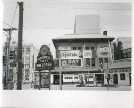
A photograph of the southeast corner of Donald Street and Graham Avenue featuring a Moore's Taxi U Drive station in the foreground. Behind it in the background can be seen The Columbus Hall / Aragon Building with advertisements for Pepsi Cola and the Rainbow Dance Gardens, and the Tribune Building can be seen at the left. This is the present site of the Millennium Library. The back of the photo is marked: "Photograph 5. Existing Conditions, corner of Graham and Donald Looking East. Urban Renewal and Rehabilitation Board City of Winnipeg".
Winnipeg (Man.). Urban Renewal and Rehabilitation Board
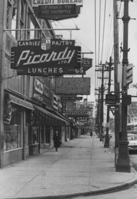
Photograph shows signs for multiple businesses, including Picardy Lunches, Scientific Hairdressing, Credit Bureau. Date of photograph is uncertain, [196-?].
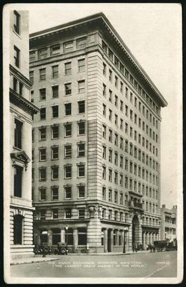
Postcard featuring the Grain Exchange Building at 167 Lombard Avenue, northeast corner of Rorie Street. The postcard is captioned "The Largest Grain Market in the World".
Photograph of "The Cove" Restaurant at 355 Portage Avenue, at Carlton Street. The photograph was taken from a building on Carlton Street looking southeast towards the Eaton's Building, Mitchell-Copp, Zeller's, and the Carlton Building.
Photograph of a large group, many on horseback, gathered for what the photograph's caption calls a "butcher's turnout" at the northwest corner of King Street and Market Avenue (the north side of Market Square). Photograph was taken by Israel Bennetto and has come apart into two pieces.
Photograph shows signs for multiple businesses, including Club Morocco, Riviera Restaurant, Princeton Café Fish and Chips, Portage Credit Jewellers. Date of photograph is uncertain, [196-?].
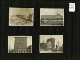
Item consists of a scrapbook page showing the Eaton's and Boyd Buildings (Item 17), unidentified building (Item 18), Royal Bank Building and Leland Hotel (Item 19), Construction of Confederation Building with Volunteer Monument in foreground (Item 20). Dates of photographs are approximate, [ca. 1913].
Photograph of a muddy Main Street in 1872, facing north from Portage Avenue and lined with shops on both sides, including a provisions store on the very right.
View of Clarks at Highway 59, southwest corner of Panet Road and Nairn Avenue, 8.5 acres. From left to right: B/A gas bar, Loblaws, Clarks Discount Store and Auto Centre, B/A gas bar, Kavanaugh's Hamburgers. Consists of 3 separate photographs pasted together on cardboard to create a panorama. The cardboard is a scrap made from an old sign of the Metropolitan Corporation of Greater Winnipeg (visible on the reverse). The cardboard is numbered “4”, presumably as part of a compilation with other shopping centre panoramas.
Metropolitan Corporation of Greater Winnipeg (Man.). Planning Division