
- i00174
- Item
- 1950
Part of City of Winnipeg (1874-1971)
A photograph of the downstream Osborne Street Bridge during the 1950 flood in Winnipeg.
Harold K. White Studio
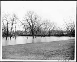
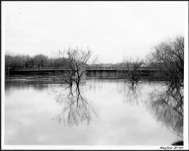
Part of City of Winnipeg (1874-1971)
A photograph of the downstream Osborne Street Bridge during the 1950 flood in Winnipeg.
Harold K. White Studio

Part of City of Winnipeg (1874-1971)
A photograph of floodwater being held back by a sandbag dike during the 1950 flood in Winnipeg.
Harold K. White Studio
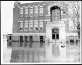
Part of City of Winnipeg (1874-1971)
A photograph of Riverview School, surrounded by floodwater, during the 1950 flood in Winnipeg.
Harold K. White Studio
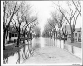
Part of City of Winnipeg (1874-1971)
A photograph of flooded Morley Avenue during the 1950 flood in Winnipeg.
Harold K. White Studio
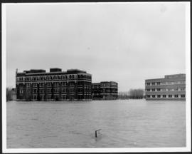
Part of City of Winnipeg (1874-1971)
A photograph of the Municipal Hospitals on Morley Street, surrounded by floodwater, during the 1950 flood in Winnipeg.
Harold K. White Studio
Part of City of Winnipeg (1874-1971)
A photograph of floodwater around the Maryland Bridge during the 1950 flood in Winnipeg.
Harold K. White Studio

Part of City of Winnipeg (1874-1971)
A photograph of a flooded underpass on Portage Avenue during the 1950 flood in Winnipeg.
Harold K. White Studio

Part of City of Winnipeg (1874-1971)
A photograph of three people walking down Sutherland Avenue, near a rock causeway, during the 1950 flood. A boat is in a flooded ditch next to a sandbag dike.
Harold K. White Studio

Part of City of Winnipeg (1874-1971)
A photograph of Higgins Avenue during the 1950 flood. A bridge over the swollen Red River can also be seen.
Harold K. White Studio
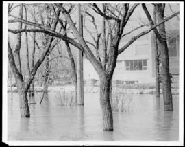
Part of City of Winnipeg (1874-1971)
A photograph of floodwater surrounding trees during the 1950 flood. A building protected by a sandbag dike is in the background.
Harold K. White Studio

Part of City of Winnipeg (1874-1971)
A photograph of the Rover Street hydro station, surrounded by water, during the 1950 flood.
Harold K. White Studio
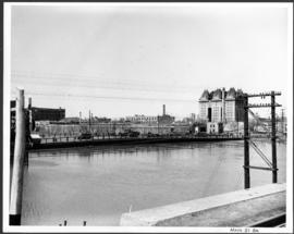
Part of City of Winnipeg (1874-1971)
A photograph of the Main Street Bridge during the 1950 flood in Winnipeg. The Hotel Fort Garry can be seen in the background.
Harold K. White Studio

Flooding on the Red River aerial view looking down on the Provencher Bridge
Part of City of Winnipeg (1874-1971)
An aerial photograph of flooding during the 1950 flood in Winnipeg. The photograph is looking down on the Provencher Bridge and downtown Winnipeg.
Harold K. White Studio

Water Street Causeway to Provencher Bridge
Part of City of Winnipeg (1874-1971)
A photograph of vehicles driving down the Water Street causeway to the Provencher Bridge during the 1950 flood in Winnipeg.
Harold K. White Studio
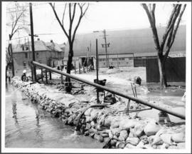
Part of City of Winnipeg (1874-1971)
A photograph of a pump and a sandbag dike during the 1950 flood in Winnipeg.
Harold K. White Studio

Part of City of Winnipeg (1874-1971)
A photograph of flooded Lombard Street during the 1950 flood in Winnipeg.
Harold K. White Studio

Bannerman and St. Cross looking east
Part of City of Winnipeg (1874-1971)
A photograph, looking east, of flooding at the intersection of Bannerman Avenue and St. Cross Street during the 1950 flood in Winnipeg.
Harold K. White Studio
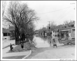
Part of City of Winnipeg (1874-1971)
A photograph, looking east, of flooding at the intersection of Atlantic Avenue and St. Cross Street during the 1950 flood in Winnipeg.
Harold K. White Studio
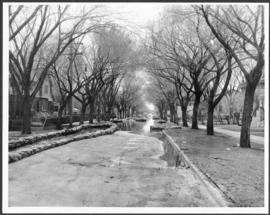
Flooding and diking in residential area
Part of City of Winnipeg (1874-1971)
A photograph of floodwater and sandbag dikes in a residential area during the 1950 flood in Winnipeg.
Harold K. White Studio

Part of City of Winnipeg (1874-1971)
A photograph of floodwater and sandbag dikes outside 368 and 372 Main Street during the 1950 flood in Winnipeg.
Harold K. White Studio