
Negatives - 2 views ? Baltimore Road
- i00383
- Item
- 1950
Part of City of Winnipeg (1874-1971)
Negatives - 2 views ? Baltimore Road Item is 6 of 6 negatives on page 27 of scrapbook.
Harold K. White Studio
78 results with digital objects Show results with digital objects
Negatives - 2 views ? Baltimore Road
Part of City of Winnipeg (1874-1971)
Negatives - 2 views ? Baltimore Road Item is 6 of 6 negatives on page 27 of scrapbook.
Harold K. White Studio
New house, 129, 133, 137, 143 and 145 Maplewood Avenue
Part of City of Winnipeg (1874-1971)
A photograph taken during the 1950 flood, showing 129 Maplewood Avenue and 133 Maplewood Avenue and 137 Maplewood Avenue and 143 Maplewood Avenue and 145 Maplewood Avenue. Item is 3 of 5 photographs on page 22 of scrapbook.
Harold K. White Studio

Part of City of Winnipeg (1874-1971)
A photograph of floodwater during the 1950 flood in Winnipeg. This photograph was taken looking north from the corner of Arnold Avenue and Hay Street; the Manitoba Legislature can be seen in the distance.
Harold K. White Studio
Part of City of Winnipeg (1874-1971)
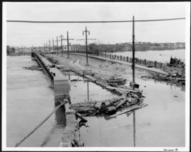
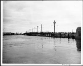
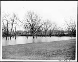
A photograph of the flooded Norwood Bridge during the 1950 flood in Winnipeg.
Harold K. White Studio
Part of City of Winnipeg (1874-1971)
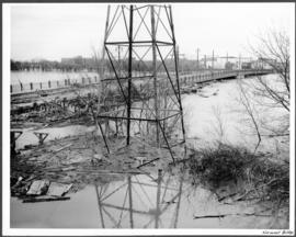
A photograph of a hydro tower and the flooded Norwood Bridge during the 1950 flood in Winnipeg.
Harold K. White Studio
Part of City of Winnipeg (1874-1971)
A photograph of the flooded Norwood Bridge during the 1950 flood in Winnipeg.
Harold K. White Studio
Part of City of Winnipeg (1874-1971)
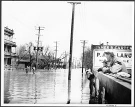
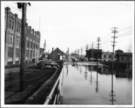
A photograph of flooded Notre Dame Avenue East during the 1950 flood in Winnipeg.
Harold K. White Studio

Part of City of Winnipeg (1874-1971)
A photograph of people boating down Oakwood Avenue in the Riverview neighbourhood during the 1950 flood in Winnipeg.
Harold K. White Studio

Part of City of Winnipeg (1874-1971)
A photograph of the intersection of Broadway and Osborne Street during the 1950 flood in Winnipeg. The photo is taken from Osborne Street, looking north; the stone cross of All Saints' Church can be seen near the left side of the image.
Harold K. White Studio
Part of City of Winnipeg (1874-1971)
A photograph of the downstream Osborne Street Bridge during the 1950 flood in Winnipeg.
Harold K. White Studio
Part of City of Winnipeg (1874-1971)
A photograph of an underpass on Osborne Street during the 1950 flood in Winnipeg.
Harold K. White Studio
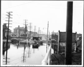
Part of City of Winnipeg (1874-1971)
A photograph of an underpass on Osborne Street during the 1950 flood in Winnipeg.
Harold K. White Studio
Part of City of Winnipeg (1874-1971)
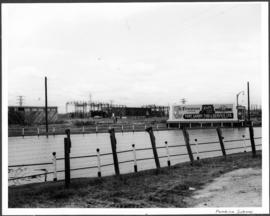
A photograph of a flooded underpass on Pembina Highway during the 1950 flood in Winnipeg.
Harold K. White Studio

Part of City of Winnipeg (1874-1971)
A photograph of a flooded underpass on Portage Avenue during the 1950 flood in Winnipeg.
Harold K. White Studio

Part of City of Winnipeg (1874-1971)
A photograph of high water surrounding a power house during the 1950 flood.
Harold K. White Studio
Part of City of Winnipeg (1874-1971)
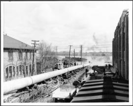
A photograph of a long pipe pumping water during the 1950 flood in Winnipeg.
Harold K. White Studio
Part of City of Winnipeg (1874-1971)
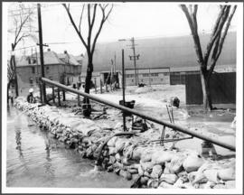
A photograph of a pump and a sandbag dike during the 1950 flood in Winnipeg.
Harold K. White Studio
Part of City of Winnipeg (1874-1971)
A photograph of two men working with pumps to remove water from the Norwood Bridge during the 1950 flood in Winnipeg.
Harold K. White Studio

Part of City of Winnipeg (1874-1971)
A photograph of a large pump on a residential street during the 1950 flood in Winnipeg.
Harold K. White Studio

Pumping water on Robert Street
Part of City of Winnipeg (1874-1971)
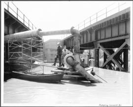
A photograph of a pipe pouring water onto tracks on Robert Street (Galt Avenue) during the 1950 flood. A pile of wood is along one side of the street. The Ogilvie Flour Mill can be seen in the background.
Harold K. White Studio