
- i00823
- Item
- 1950
Part of City of Winnipeg (1874-1971)
A photograph taken during the 1950 flood, showing 96 Eastgate. Item is 1 of 2 photographs on page 96 of scrapbook.
Harold K. White Studio
78 results with digital objects Show results with digital objects
Part of City of Winnipeg (1874-1971)
A photograph taken during the 1950 flood, showing 96 Eastgate. Item is 1 of 2 photographs on page 96 of scrapbook.
Harold K. White Studio
Part of City of Winnipeg (1874-1971)
A photograph taken during the 1950 flood, showing between 39 and 51 Eastgate. Item is 1 of 2 photographs on page 98 of scrapbook.
Harold K. White Studio
Part of City of Winnipeg (1874-1971)
A photograph taken during the 1950 flood, showing 51 Eastgate. Item is 2 of 2 photographs on page 98 of scrapbook.
Harold K. White Studio
Part of City of Winnipeg (1874-1971)
A photograph taken during the 1950 flood, showing 58 Middlegate. Item is 2 of 2 photographs on page 102 of scrapbook.
Harold K. White Studio
Part of City of Winnipeg (1874-1971)
A photograph taken during the 1950 flood, showing 58 Middlegate. Item is 1 of 2 photographs on page 103 of scrapbook.
Harold K. White Studio
Part of City of Winnipeg (1874-1971)
A photograph taken during the 1950 flood, showing 106 Middlegate. Item is 1 of 2 photographs on page 105 of scrapbook.
Harold K. White Studio
Part of City of Winnipeg (1874-1971)
A photograph taken during the 1950 flood, showing 111 Middlegate. Item is 2 of 2 photographs on page 106 of scrapbook.
Harold K. White Studio

Part of City of Winnipeg (1874-1971)
A photograph of three people walking down Sutherland Avenue, near a rock causeway, during the 1950 flood. A boat is in a flooded ditch next to a sandbag dike.
Harold K. White Studio

Part of City of Winnipeg (1874-1971)
A photograph of Higgins Avenue during the 1950 flood. A bridge over the swollen Red River can also be seen.
Harold K. White Studio
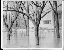
Part of City of Winnipeg (1874-1971)
A photograph of floodwater surrounding trees during the 1950 flood. A building protected by a sandbag dike is in the background.
Harold K. White Studio

Part of City of Winnipeg (1874-1971)
A photograph of the Rover Street hydro station, surrounded by water, during the 1950 flood.
Harold K. White Studio

Part of City of Winnipeg (1874-1971)
A photograph of the Rover Street hydro station, surrounded by water, during the 1950 flood.
Harold K. White Studio

Part of City of Winnipeg (1874-1971)
A photograph of the Rover Street hydro station, surrounded by water, during the 1950 flood. A group of people are walking on the sandbag dike that surrounds the building.
Harold K. White Studio
Part of City of Winnipeg (1874-1971)
A photograph of the Main Street Bridge during the 1950 flood in Winnipeg. The Hotel Fort Garry can be seen in the background.
Harold K. White Studio

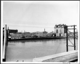
Flooding on the Red River aerial view looking down on the Provencher Bridge
Part of City of Winnipeg (1874-1971)
An aerial photograph of flooding during the 1950 flood in Winnipeg. The photograph is looking down on the Provencher Bridge and downtown Winnipeg.
Harold K. White Studio

Water Street Causeway to Provencher Bridge
Part of City of Winnipeg (1874-1971)
A photograph of vehicles driving down the Water Street causeway to the Provencher Bridge during the 1950 flood in Winnipeg.
Harold K. White Studio
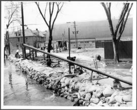
Part of City of Winnipeg (1874-1971)
A photograph of a pump and a sandbag dike during the 1950 flood in Winnipeg.
Harold K. White Studio

Part of City of Winnipeg (1874-1971)
A photograph of flooded Lombard Street during the 1950 flood in Winnipeg.
Harold K. White Studio

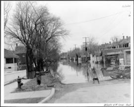
Bannerman and St. Cross looking east
Part of City of Winnipeg (1874-1971)
A photograph, looking east, of flooding at the intersection of Bannerman Avenue and St. Cross Street during the 1950 flood in Winnipeg.
Harold K. White Studio
Part of City of Winnipeg (1874-1971)
A photograph, looking east, of flooding at the intersection of Atlantic Avenue and St. Cross Street during the 1950 flood in Winnipeg.
Harold K. White Studio