
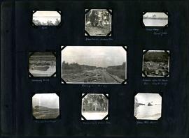
William Smaill Photo Album – Page 54
- p00172
- Part
- [1914 or 1915]
Part of William Smaill fonds
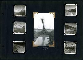
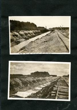
Captions read: Class 14 in muskeg, mile 86.
Smaill, William
93 results with digital objects Show results with digital objects
William Smaill Photo Album – Page 54
Part of William Smaill fonds
Captions read: Class 14 in muskeg, mile 86.
Smaill, William
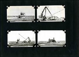
William Smaill Photo Album – Page 75
Part of William Smaill fonds
Smaill, William
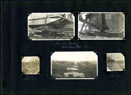
William Smaill Photo Album – Page 86
Part of William Smaill fonds
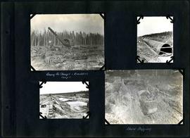
Captions read: Bay City dredge, Brokenhead River, March15 - Site for camp 8, December 15 - Camp 8, December 15.
Smaill, William
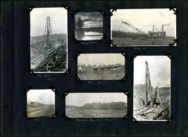
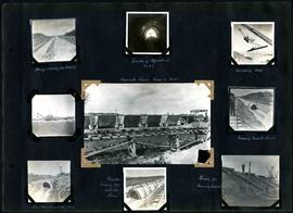
William Smaill Photo Album – Page 92
Part of William Smaill fonds
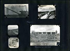
Captions read: Pile driver, mile 85 plus - Headquarter - Mile 86 - 4.5% grade - Mile 85 - Dominion Day, 1915, camp 6 - Mile 85 plus.
Smaill, William
William Smaill Photo Album – Page 106
Part of William Smaill fonds
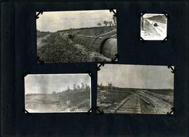
Captions read: Dyke - Blanchard's, Indian Bay - Indian Camp, Shoal Lake [Kekekoziibii Shoal Lake 40 First Nation] - Removing arch - Camp 5, mile 77 - Remains after oil House fire, camp 5, mile 77 - Excursion train, camp 6 -Tennis court, Indian Bay - Young wild ducks.
Smaill, William

William Smaill Photo Album – loose page
Part of William Smaill fonds
Captions read: Bunk houses, rock plant, Greater Winnipeg Water District - Rock crushing plant, Greater Winnipeg Water District.
Smaill, William

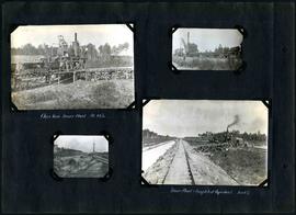
William Smaill Photo Album – Page 32
Part of William Smaill fonds
Captions read: Concrete mixers, mile 77.
Smaill, William

William Smaill Photo Album – Page 36
Part of William Smaill fonds
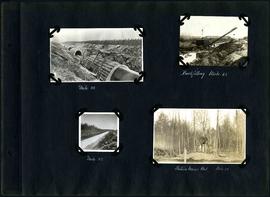
Captions read: Culvert, mile 77 - In muskeg, mile 58 - Ditch after heavy rain, mile 57 - Muskeg, mile 58 - Shaping bottom for inverts camp, mile 57.5.
Smaill, William

William Smaill Photo Album – Page 37
Part of William Smaill fonds
Captions read: Blaw Forms - Camp 2, Mile 57, Rear View - 8 foot clear muskeg - Camp 2, front view.
Smaill, William
William Smaill Photo Album – Page 40
Part of William Smaill fonds
Captions read: Dump ready for track - Inside of Aqueduct, mile 65 - Handling pads - Concrete train camp 3, mile 65 - Moving inside forms - First arch poured, mile 64 - Traveler moving the outside forms - Ready for pouring invert.
Smaill, William
William Smaill Photo Album – Page 43
Part of William Smaill fonds
Captions read: Close view, mixer plant, mile 64 1/2 - Mixer plant and completed aqueduct, mile 64.5.
Smaill, William
William Smaill Photo Album – Page 45
Part of William Smaill fonds
Captions read: Moving dragline and outfit back to backfill at camp 3, mile 66.
Smaill, William
William Smaill Photo Album – Page 62
Part of William Smaill fonds
Captions read: Among the stumps and Boulders, camp 1 - Hard digging.
Smaill, William
William Smaill Photo Album – Page 63
Part of William Smaill fonds
Captions read: Camp 1 - Taking train up a 4% grade.
Smaill, William
William Smaill Photo Album – Page 74
Part of William Smaill fonds
Smaill, William
William Smaill Photo Album – Page 80
Part of William Smaill fonds
Captions read: Mile 58 - Backfilling, mile 65 - Mile 85 - Station mens hut, mile 70.
Smaill, William
William Smaill Photo Album – loose page
Part of William Smaill fonds
Captions read: Tube partly covered, Greater Winnipeg Water District.
Smaill, William
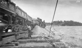
Placing material on Falcon River Diversion Dyke at Indian Bay
Photograph of workers using a scow to place material from cars onto the Falcon River Diversion Dyke at Indian Bay. Photograph taken by William G. Chace, Chief Engineer of the Winnipeg Aqueduct.
Greater Winnipeg Water District
Part of William Smaill fonds
Item consists of a photo album created by William Smaill, Superintendent of the Winnipeg Aqueduct Construction Company, Ltd. The album contains photographs of the aqueduct’s construction, company men and their families, recreation, camps and homes used during construction, the Greater Winnipeg Water District Railway, and the surrounding landscape (Shoal Lake, Whitemouth River, Indian Bay, Birch River). There are also several photos of Winnipeg during Decoration Day 1914, photos of Mayors T.R. Deacon, Thomas Sharpe, and R.D. Waugh, and two photos of an Anishinaabe camp at Kekekoziibii Shoal Lake 40 First Nation.
The photos are heavily annotated. The annotations consist of names, locations, descriptions, and sometimes the section or specific mile of the aqueduct. A few photos appear to be missing and there are several loose pages with similar content. The photos are arranged somewhat chronologically – photos from 1914 generally precede photos from 1915 – but there are many exceptions.
Smaill, William

William Smaill Photo Album – Page 17
Part of William Smaill fonds
Captions read: First bucket on aqueduct - Erection number 3 class 7 at mile 64.
Smaill, William