

Aerial view of Point Douglas, St. Boniface, and Elmwood areas
- i03883
- Item
- [1940s?]
Aerial photograph of Point Douglas, St. Boniface, and west Elmwood.
177 results with digital objects Show results with digital objects
Aerial view of Point Douglas, St. Boniface, and Elmwood areas
Aerial photograph of Point Douglas, St. Boniface, and west Elmwood.

Central Business District: Aerial view - Central Winnipeg
Date of photograph is approximate, ca. 1947.
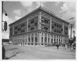
Royal Alexandra Hotel, northeast Higgins and Main
Date of photograph is approximate, ca. 1946.
![Vicinity of Elmwood Park [Aerial view]](/uploads/r/city-of-winnipeg-archives-amp-records-control-branch/5/b/9/5b929d618c2f619e557788462eee14587693511e7959bc6ca77ae96654d1bc98/C0013_0000_0000_P0018_0041_001_142.jpg)
Vicinity of Elmwood Park [Aerial view]
Inscription (on recto): WG M35: 3-15, 5 Mar '45, vicinity Elmwood Park Wpg, appr. scale 1/12000.
![Kildonan Park [Aerial view]](/uploads/r/city-of-winnipeg-archives-amp-records-control-branch/f/5/8/f589f26a584950aadbe5b101158e69cde3cad16f0f0cf05dcbb2a97e34661f16/C0013_0000_0000_P0018_0037_001_142.jpg)
Inscription (on recto): WG M35: 2-18, 5 Mar. '45, Kildonan Park, Wpg [Winnipeg], appr. scale 1/12000.
![Vicinity of Elmwood Park [Aerial view]](/uploads/r/city-of-winnipeg-archives-amp-records-control-branch/c/6/d/c6dc0bd0b8c2199f232fe8c7f5245d25e681a6a759be00e013a35a7a1ecada23/C0013_0000_0000_P0018_0042_001_142.jpg)
Vicinity of Elmwood Park [Aerial view]
Inscription (on recto): WG M35: 3-16, 5 Mar '45, vicinity Elmwood Park Wpg, appr scale 1/12000.

Photograph shows an aerial view of the Red River north from the southern boundaries of North Kildonan and West St. Paul, north of Winnipeg. Photograph is dated December 2, 1943.
![Logan Avenue and Main Street [Aerial view]](/uploads/r/city-of-winnipeg-archives-amp-records-control-branch/d/9/2/d92728eee72f0ac3b14bbb8ea8f04c5d3ece08f19538ee5d078eb79492de602b/C0013_0000_0000_P0018_0034_001_142.jpg)
Logan Avenue and Main Street [Aerial view]
Inscription (on recto): A160 3-9-43 Logan Ave and Main St Wpg [Winnipeg] about 4000' 5".
Portage Avenue and Main Street looking north

Southeast corner of back lane, north side of Market Avenue and Main Street, circa 1941
Photograph shows present site of the Centennial Concert Hall. Cristall's Mens Outfitters and Klasser's Mail Order House visible in photograph.
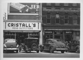
Southeast corner of back lane, north side of Market Avenue and Main Street, circa 1941
Photograph shows present site of the Centennial Concert Hall. Cristall's Mens Outfitters visible in photograph.

View of Main Street south from Higgins showing Alberta Hotel
Date of photograph is uncertain, [before 1949].
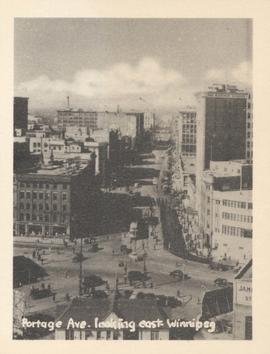
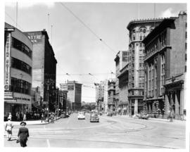
Portage Ave. looking east, Winnipeg
Photograph show Portage Avenue looking east from Main Street. Date of photograph is approximate, ca. 1940.


Union Station, Winnipeg, Manitoba
Photograph shows Canadian National Railway Station (C.N.R. Station) on Main Street. Date of photograph is approximate, ca. 1940.

C.N.R. Station, Winnipeg, Man.
Photograph shows Canadian National Railway Station situated on Main Street.

City Hall, Winnipeg, Man. showing "Welcome Visitors" sign
Photograph shows Winnipeg's second city hall (1886-1962). Date of photograph is approximate, ca. 1940.
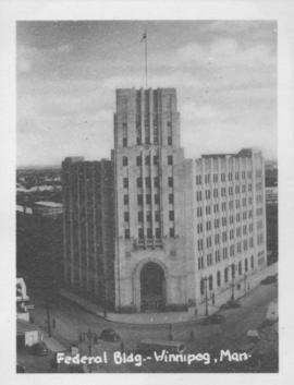
Photograph shows Federal building located on Main Street at Water Avenue.
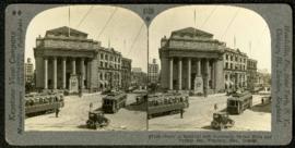
Bank of Montreal building, Portage and Main
Part of Morris Block collection
A promotional stereogram showing traffic and streetcars in front of the Bank of Montreal building at Portage Avenue and Main Street, made by the Keystone View Company. The reverse side of the image contains information about Winnipeg.
Block, Morris

Corner Portage Avenue and Main Street, Winnipeg, Manitoba
Print is a photographic image of the intersection of Portage Avenue and Main Street. Date of print is uncertain, [193-].