

William Ashdown - removal of dead horse
- d01042
- File
- 1874
Part of City of Winnipeg (1874-1971)
Requesting removal of a dead horse lying in the vicinity of the Methodist Church in the North Ward.
Winnipeg (Man.). City Council
William Ashdown - removal of dead horse
Part of City of Winnipeg (1874-1971)
Requesting removal of a dead horse lying in the vicinity of the Methodist Church in the North Ward.
Winnipeg (Man.). City Council

Wildwood Park - Three weeks before flood, 1950

Wildwood Park - Three weeks before flood, 1950
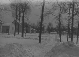
Wildwood Park - Three weeks before flood, 1950
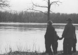
Photograph shows four people on riverbank looking out at high waters and flooded area in Wildwood Park during 1950 Flood.
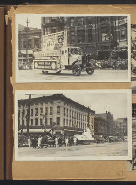
White Star float and parade at corner of Main and Market
Part of City of Winnipeg (1874-1971)
Winnipeg (Man.). Special Jubilee Committee

Part of The W.R.E.N.C.H. Winnipeg Cycling Archive collection
The W.R.E.N.C.H.
Wheeler and Kahlen - license for a hotel in Point Douglas (near the hospital)
Part of City of Winnipeg (1874-1971)
Winnipeg (Man.). City Council
Part of City of Winnipeg (1874-1971)
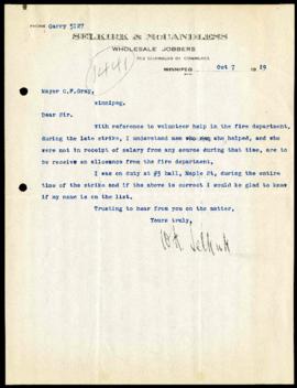
A letter from W.H. Selkirk to Mayor Gray requesting compensation for his work as a volunteer firefighter at the number 3 hall on Maple Street during the General Strike.
Winnipeg (Man.). Mayor's Office

Westwood Shopping Centre panorama
View of Westwood Shopping Centre, 3276-3332 Portage Avenue, 10.2 acres. From left to right: various shops, motel, various shops and Assiniboia Public Library, Safeway Store, Marshall Wells, Perths, Westwood Pharmacy, various Shops, Zeller's County Fair, Auto Centre. Consists of 3 separate photographs pasted together on cardboard to create a panorama. The cardboard is a scrap made from an old sign of the Metropolitan Corporation of Greater Winnipeg (visible on the reverse). The cardboard is numbered “10”, presumably as part of a compilation with other shopping centre panoramas.
Metropolitan Corporation of Greater Winnipeg (Man.). Planning Division
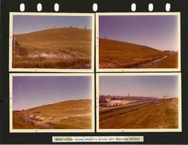
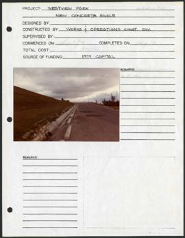
Westview Park – Saskatchewan Landfill – west slope
4 photographs of the west slope of Westview Park, along Omand’s Creek and Empress Street. Photographs are affixed to a black page.
Winnipeg (Man.). Parks and Recreation Department
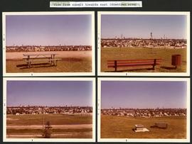
Westview Park – Saskatchewan Landfill – view from summit
4 photographs taken from the summit of Westview Park, facing east. Photographs are affixed to a black page.
Winnipeg (Man.). Parks and Recreation Department
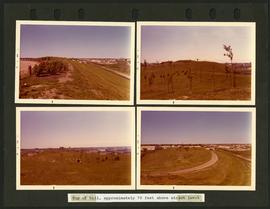
Westview Park – Saskatchewan Landfill – top of hill
4 photographs of the top of the hill of Westview Park, approximately 70 feet above street level. Photographs are affixed to a black page.
Winnipeg (Man.). Parks and Recreation Department
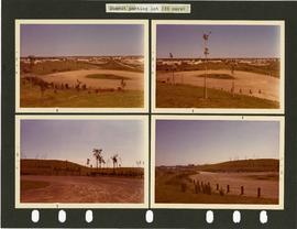
Westview Park – Saskatchewan Landfill – summit parking lot
4 photographs of the parking lot at the summit of Westview Park. Photographs are affixed to a black page.
Winnipeg (Man.). Parks and Recreation Department
Westview Park – Saskatchewan Landfill – project development components
Project development components form for Westview Park with a colour photograph affixed.
Winnipeg (Man.). Parks and Recreation Department
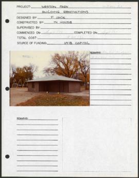
Weston Park – project development components
Project development components form for Weston Park with a colour photograph affixed.
Winnipeg (Man.). Parks and Recreation Department
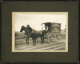
Western Cake and Pie Co carriage
Part of Morris Block collection
Photograph mounted on cardboard of the horse-drawn delivery wagon of the Western Cake and Pie Comapany, owned by Crane and David, who owned a bakery at 765 Dufferin Avenue.
Block, Morris

Westboine Park – project development components
Project development components form for Westboine Park with 2 colour photographs affixed.
Winnipeg (Man.). Parks and Recreation Department
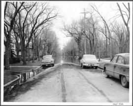
Part of City of Winnipeg (1874-1971)
A photograph of flooding on West Gate during the 1950 flood in Winnipeg.
Harold K. White Studio
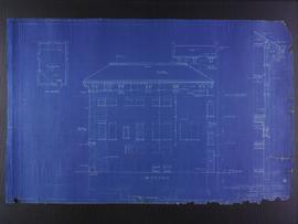
West elevation plans for the Club Building for the Columbus Hall Association
Part of City of Winnipeg (1874-1971)
Blueprint plans of west elevation of the Club Building for the Columbus Hall Association Ltd. on the southwest corner of Graham Avenue and Smith Street. Designed by John D. Atchison. Drawing 8 of 11.
Atchison, John D.