
- i03984
- Item
- 1947
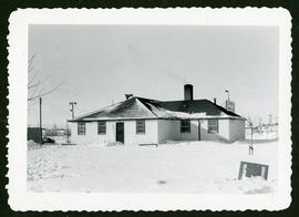
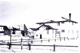
Winter photograph of the exterior of the Crescentwood Community Club.
3968 results with digital objects Show results with digital objects
Winter photograph of the exterior of the Crescentwood Community Club.
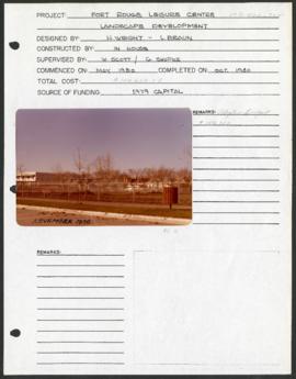
Fort Rouge Leisure Centre – project development components
Project development component form for the Fort Rouge Leisure Center with a colour photograph attached.
Winnipeg (Man.). Parks and Recreation Department
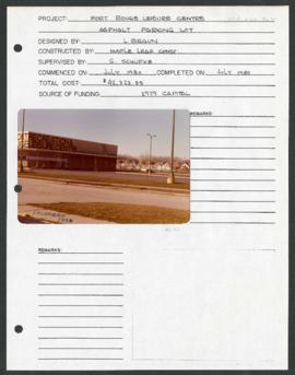
Fort Rouge Leisure Centre – project development components
Project development component form for the Fort Rouge Leisure Center with a colour photograph attached.
Winnipeg (Man.). Parks and Recreation Department
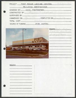
Fort Rouge Leisure Centre – project development components
Project development component form for the Fort Rouge Leisure Center with a colour photograph attached.
Winnipeg (Man.). Parks and Recreation Department
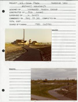
Harbourview Recreation Complex – project development components
Project development component form for the Harbourview Recreation Complex in Kil-cona Park.
Winnipeg (Man.). Parks and Recreation Department
Exterior of Kelvin Community Centre
Photograph of the exterior of the Kelvin Community Centre.

New boulevards on street north from Palmerston Avenue.
View of new boulevards on an unidentified street in the Wolseley area, facing north from Palmerston Avenue.
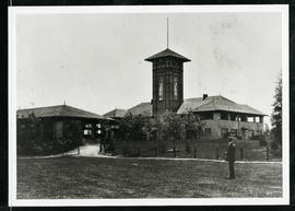
Assiniboine Park Pavilion and Annex
A man standing in front of the Pavilion and Annex at Assiniboine Park.
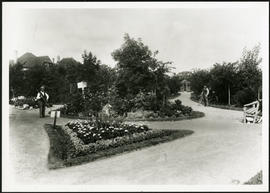
Album page with two photographs of Central Park, one on each side. Photographs are numbered by the photographer (Steele and Company) as a861 and a861a.
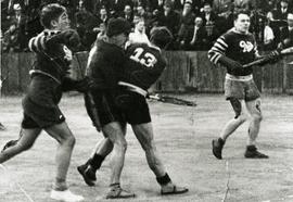
Elmwood Pats competing in lacrosse game
Action shot of the Elmwood Pats playing lacrosse, likely at the Kelvin Community Centre.
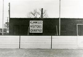
Original boxcar clubhouse at Kelvin Community Centre
The original boxcar clubhouse at the Kelvin Community Centre with a sign reading “Elmwood Visitors Quarter”.
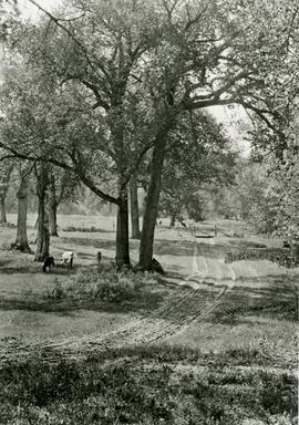
A photograph of cows grazing in Fraser’s Grove Park in East Kildonan.

Plan of University section of Tuxedo Park
A map of the proposed Tuxedo Park residential suburb, specifically the area surrounding the old University of Manitoba campus and Olmsted and Assiniboine Parks. The map shows streets and lots as well as details of the university campus. The map was created by Charles Clifton Chataway (1869-1920) and Bulman Brothers Ltd.

Notre Dame Avenue facing west from Arlington Street
View of the boulevard on Notre Dame Avenue facing west, between Arlington and McPhillips Streets. Free Press Depot Number 2 can be seen on the right.

Program for Winnipeg’s 50 year Jubilee reunion dinner
Part of City Clerk's Library collection
A program and invitation for a dinner held on June 18, 1924 to celebrate Winnipeg’s 50th anniversary. The booklet contains a list of those invited, a dinner menu, a list of past and present mayors and councillors, and a space to collect autographs.
Winnipeg (Man.)

Program to official opening of the 1964 City Hall
Part of City Clerk's Library collection
A program and informational booklet detailing the ceremonial opening of the new City Hall on October 5, 1964. The booklet contains an event program, a list of officials, a message from Mayor Stephen Juba, a brief history of Winnipeg and City Hall, and details and photographs about the new City Hall’s construction. The program was Lithographed by Bulman Brothers Ltd.
Winnipeg (Man.)
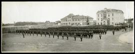
78th Overseas Battalion (Winnipeg Grenadiers)
Panorama of the 78th Oversees Battalion (Winnipeg Grenadiers) lined up in formation at Fort Osborne Barracks. Photograph taken by Royal Studio.
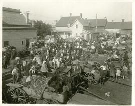
The North End market behind Dufferin Avenue and Derby Street
Carts of goods and shoppers in a bustling market around Dufferin Avenue and Derby Street in the North End.

Northdale Shopping Centre panorama
View of Northdale Shopping Centre, 963 Henderson Highway, 7.65 acres. From left to right: Loblaws Groceteria, Zeller's County Fair, various shops, the Royal Bank, the Canadian Imperial Bank of Commerce, A & P Food Store, Lord Wolseley School. Consists of 3 separate photographs pasted together on cardboard to create a panorama. The cardboard is a scrap made from an old sign of the Metropolitan Corporation of Greater Winnipeg (visible on the reverse). The cardboard is numbered “1”, presumably as part of a compilation with other shopping centre panoramas.
Metropolitan Corporation of Greater Winnipeg (Man.). Planning Division