

Overhanging Signs: North side of Portage Avenue
- i01487
- Item
- [196-?]
Photograph shows sign for Club Morocco. Date of photograph is uncertain, [196-?].
55 results with digital objects Show results with digital objects
Overhanging Signs: North side of Portage Avenue
Photograph shows sign for Club Morocco. Date of photograph is uncertain, [196-?].

Overhanging Signs: North side of Portage Avenue looking East from Langside Street
Photograph shows signs for multiple businesses, including Club Morocco and Aqua-Terre Pet & Sporting Goods. Date of photograph is uncertain, [196-?].
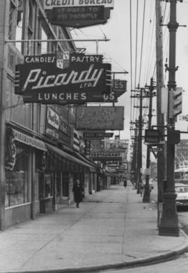
Overhanging Signs: North side of Portage Avenue looking East from Vaughan Street
Photograph shows signs for multiple businesses, including Picardy Lunches, Scientific Hairdressing, Credit Bureau. Date of photograph is uncertain, [196-?].

Overhanging Signs: North side of Portage Avenue looking West from Young Street
Photograph shows signs for multiple businesses, including Club Morocco, Riviera Restaurant, Princeton Café Fish and Chips, Portage Credit Jewellers. Date of photograph is uncertain, [196-?].
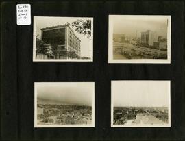
Photograph album of Winnipeg during WW1: Page 3
Item consists of a scrapbook page showing the Young Men's Christian Association (YMCA) Building at 301 Vaughan Street (Item 13); view of Portage Avenue with Eaton's and Boyd buildings in foreground and Hotel Fort Garry in the background (Item 14); view of Ashford's Bakery at Portage Avenue and Furby Street, facing south towards Broadway (Item 15); Vaughan Street facing north towards St. Paul's College on Ellice Avenue (Item 16). Dates of photographs are approximate, [ca. 1913].
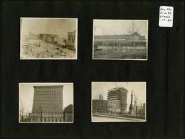
Photograph album of Winnipeg during WW1: Page 4
Item consists of a scrapbook page showing the Eaton's and Boyd Buildings (Item 17), unidentified building (Item 18),
Royal Bank Building and Leland Hotel (Item 19), Construction of Confederation Building with Volunteer Monument in foreground (Item 20). Dates of photographs are approximate, [ca. 1913].

Photograph album of Winnipeg during WW1: Page 5
Item consists of a scrapbook page showing soldiers lined up in military parade in front of the Industrial Bureau Exposition Building (Item 21), soldiers lined up in military parade (Item 22),
soldiers on horse in military parade in front of the Industrial Bureau Exposition Building (Item 23), crowd forming on street in front of the Israelite Jewish Daily newspaper building (975 Main Street) and the H. Lindster's Bakery (971 Main Street). Soldiers and Police in foreground (Item 24), [ca. 1913].

Photograph album of Winnipeg during WW1: Page 6
Item consists of a scrapbook page showing soldiers marching in military parade on street in front of the Elliott and Hazel Grocers, 975 Main Street and the H. Lindster's Bakery, 971 Main Street (Item 25), soldiers lined up in military parade (Item 26),
soldiers marching in military parade (Item 27), soldiers marching in military parade (Item 28), [ca. 1913].

Portage Avenue looking west from Colony Street
A view of Portage Avenue looking west from Colony Street. The Hudson's Bay Company Building is featured prominantly and the Power Building and the Boyd Building are visible farther west.

Portage Avenue looking west from Colony Street
A view of Portage Avenue looking west from Colony Street. The Hudson's Bay Company Building is featured prominantly and the Power Building is visible farther west. Playing "Young Mr. Lincoln", the Gaiety Theatre can be seen across the street with two poli
Photographs of buildings on Portage Avenue including the Bank of Montreal, Zeller's, the Power Building, Winnipeg Electric Co. and the Royal Bank Building.
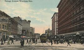
Portage Avenue, Winnipeg, Man.
Postcard shows view from Portage Avenue and Hargrave Street. The T. Eaton Co. Ltd. department store is shown at right; Clarendon Hotel is shown at left. Date of postcard is uncertain, [before 1949].
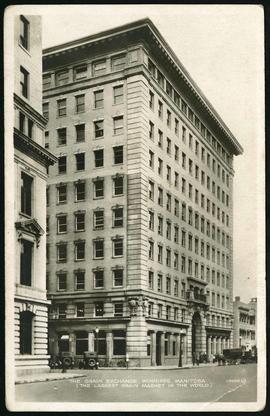
Postcard of Grain Exchange Building
Postcard featuring the Grain Exchange Building at 167 Lombard Avenue, northeast corner of Rorie Street. The postcard is captioned "The Largest Grain Market in the World".
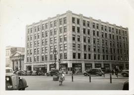
Power Building and Hudson's Bay Company Building
View of the North side of the corner of Portage Avenue and Vaughan Street, featuring the Power Building and Hudson's Bay Company Building. I front are parked cars and a street car passing by.
Prairies Cities Oil Service Station, Graham and Fort
Date of photograph is approximate, ca. 1937.
![Side view of Drug Store [Dunlop Drug Store - January 25, 1918]](/uploads/r/city-of-winnipeg-archives-amp-records-control-branch/9/7/c/97c0e1ca7dce9cc12cb7481bda6214c7c2576dd2fb09909be39f08f4404a5194/C0013_0000_0000_P0022_0095_047_142.jpg)
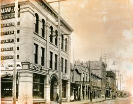
South West Corner of King and William
Item is a photographic reproduction, date unknown (original created ca. 1900). Shows the south west corner of King Street and William Avenue.

Southeast corner of back lane, north side of Market Avenue and Main Street, circa 1941
Photograph shows present site of the Centennial Concert Hall. Cristall's Mens Outfitters and Klasser's Mail Order House visible in photograph.
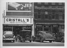
Southeast corner of back lane, north side of Market Avenue and Main Street, circa 1941
Photograph shows present site of the Centennial Concert Hall. Cristall's Mens Outfitters visible in photograph.
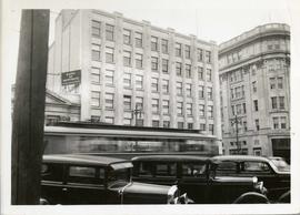
Storefronts in the Power Building
A view of cars and shoppers outside the Power Building at the corner of Portage Avenue and Vaughan Street. Street level storefronts include the Winnipeg Electric Company showroom and Rexall / Liggett's drug store. Above are the offices of Western Empire L