
- p00288
- Part
- Mar. 1909
Part of City of Winnipeg (1874-1971)
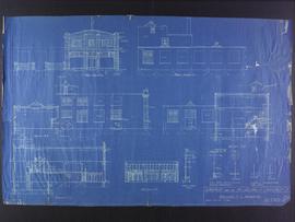
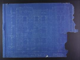
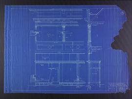
Blueprint elevation and section plans of a Garage for the McLaughlin Carriage Co., at Maryland Street and Portage Avenue. Designed by J.D. Atchison. Drawing 2 of 2.
Atchison, John D.
Part of City of Winnipeg (1874-1971)
Blueprint elevation and section plans of a Garage for the McLaughlin Carriage Co., at Maryland Street and Portage Avenue. Designed by J.D. Atchison. Drawing 2 of 2.
Atchison, John D.

Main Street looking north from Portage Avenue
Part of City of Winnipeg (1874-1971)
Bentley Building, Courthouse and Artesian well shown in photograph.

North side of Lombard, Rorie to Main Street
Part of City of Winnipeg (1874-1971)
A photograph of storefronts and advertisements on the north side of Lombard Avenue, between Rorie Street and Main Street. The photograph is part of small album containing photographs of maps tracking the outbreak of typhoid from 1905 to 1909 and other scenes. Item is loose and at back of album.
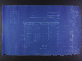
North elevation plans for the Club Building for the Columbus Hall Association
Part of City of Winnipeg (1874-1971)
Blueprint plans of north elevation of the Club Building for the Columbus Hall Association Ltd. on the southwest corner of Graham Avenue and Smith Street. Designed by John D. Atchison. Drawing 7 of 11.
Atchison, John D.
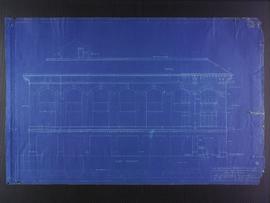
West elevation plans for the Club Building for the Columbus Hall Association
Part of City of Winnipeg (1874-1971)
Blueprint plans of west elevation of the Club Building for the Columbus Hall Association Ltd. on the southwest corner of Graham Avenue and Smith Street. Designed by John D. Atchison. Drawing 8 of 11.
Atchison, John D.
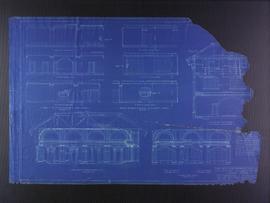
Miscellaneous elevation plans for the Club Building for the Columbus Hall Association
Part of City of Winnipeg (1874-1971)
Blueprint plans of miscellaneous elevations of the Club Building for the Columbus Hall Association Ltd. on the southwest corner of Graham Avenue and Smith Street. Designed by John D. Atchison. Drawing 10 of 11.
Atchison, John D.
Footing details for Medical Arts Building at the corner of Graham Avenue and Kennedy Street
Part of City of Winnipeg (1874-1971)
Blueprint plans of footing details of the Medical Arts Building at the corner of Graham Avenue and Kennedy Street. Designed by John D. Atchison. Drawing 6 of 6.
Atchison, John D.
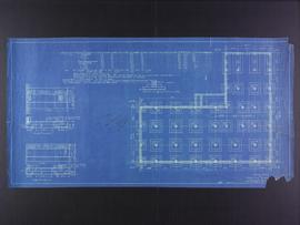
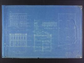
Floor plans for Garage for the McLaughlin Carriage Co., Maryland Street and Portage Avenue
Part of City of Winnipeg (1874-1971)
Blueprint floor plans of a Garage for the McLaughlin Carriage Co., at Maryland Street and Portage Avenue. Designed by J.D. Atchison. Drawing 1 of 2.
Atchison, John D.

Winnipeg, Main Street looking south, Summer 1875
Part of City of Winnipeg (1874-1971)
Photograph taken from top of Courthouse.

Part of City of Winnipeg (1874-1971)
Photograph shows the North End Farmer's Market (west side Main Street, north of Stella Avenue, looking west to King Street). Included in photograph: front entrance to market, automobiles parked on street, and North End Horse Exchange (523 King Street). Photograph likely taken from 919-921 Main Street by city employee.

Part of City of Winnipeg (1874-1971)
Photograph shows the North End Farmer's Market, looking east across Main Street (northwest Main Street and Stella Avenue). Included in photograph: stalls filled with vegetables and people walking through the market, Aime Bicycle Shop, 909 Main Street, two-storey brick building (899-905 Main Street), and Norquay School.

Part of City of Winnipeg (1874-1971)
Photograph of the Winnipeg Renovating Co. and the Grain Exchange on Lombard Avenue. Item is part of small album containing photographs of maps tracking the outbreak of typhoid from 1905 to 1908 and other scenes. Item is loose and at back of album. Date of item is approximate, [circa 1909].

Part of City of Winnipeg (1874-1971)
Photograph of the Winnipeg Renovating Co. on Lombard Avenue. Item is part of small album containing photographs of maps tracking the outbreak of typhoid from 1905 to 1908 and other scenes. Item is loose and at back of album. Date of item is approximate, [circa 1909].

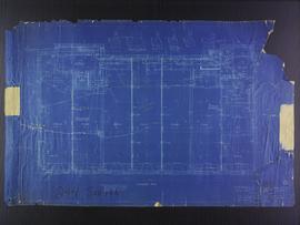
Roof plans for 383-389 Portage Avenue and 290 Edmonton Street (The Edmonton Block)
Part of City of Winnipeg (1874-1971)
Blueprint plans of roof of 383-389 Portage Avenue and 290 Edmonton Street (the Edmonton Block), designed by John. D. Atchison for W.H. Gardner. Drawing 4 of 6.
Atchison, John D.
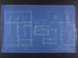
Basement plans the Club Building for the Columbus Hall Association
Part of City of Winnipeg (1874-1971)
Blueprint plans of basement of the Club Building for the Columbus Hall Association Ltd. on the southwest corner of Graham Avenue and Smith Street. Designed by John D. Atchison. Drawing 1 of 11.
Atchison, John D.
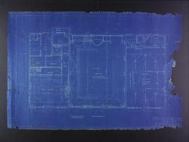
Fourth floor plans for the Club Building for the Columbus Hall Association
Part of City of Winnipeg (1874-1971)
Blueprint plans of fourth floor of the Club Building for the Columbus Hall Association Ltd. on the southwest corner of Graham Avenue and Smith Street. Designed by John D. Atchison. Drawing 5 of 11.
Atchison, John D.
Part of City of Winnipeg (1874-1971)
Blueprint plans of Kennedy street elevation of the Medical Arts Building at the corner of Graham Avenue and Kennedy Street. Designed by John D. Atchison. Drawing 4 of 6.
Atchison, John D.
Facade plans for business premises for Mr. Nation, Portage Avenue
Part of City of Winnipeg (1874-1971)
Blueprint facade plans of the business premises of Mr. Nanton on Portage Avenue. Designed by J.D. Atchison. Drawing 3 of 3.
Atchison, John D.
Elevation plans for business premises of Mr. F.J. Sharpe, Portage Avenue
Part of City of Winnipeg (1874-1971)
Blueprint elevation plans of the business premises of Mr. F.J. Sharpe on Portage Avenue. Designed by J.D. Atchison. Drawing 2 of 2. Originally drawn on May 10, 1919, but revised on July 14, 1919.
Atchison, John D.