
- i04545
- Item
- [ca. 1912]
Part of Morris Block collection
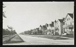
Photograph of houses on Edmonton Street, likely south of Portage Avenue.
Block, Morris
Part of Morris Block collection
Photograph of houses on Edmonton Street, likely south of Portage Avenue.
Block, Morris
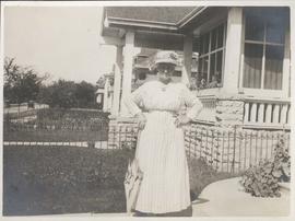
Neta Turner in front of house in Fort Garry, Winnipeg
Date of photograph is approximate, ca. 1918.
Our place - 49 Balmoral Place, Winnipeg, Manitoba
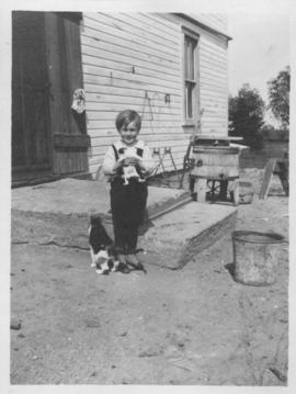
Elva, Manitoba, June 1918, Ken Furtney
Photograph shows child (Ken Furtney) holding kitten, wooden wash tub for laundry in background.

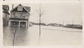
Floods - St. Boniface and Norwood - April 1916
Postcard is a photographic print showing water flooding homes. Photograph taken by Advance Photo Company, Winnipeg. Azo mark appears in stamp box, made in Canada.

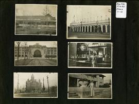
Photograph album of Winnipeg during WW1: Page 2
Item consists of a scrapbook page showing unidentified building (Item 7), Industrial Bureau Exhibition Building (Item 8), Canadian National Railway station (C.N.R. station) from Broadway looking east (Item 9), unidentified woman standing in front of residential building (Item 10), City Hall and Volunteer Monument (second City Hall) (Item 11), unidentified woman posing in front of what is likely the Assiniboine Park Pavilion (Item 12). Dates of photographs are approximate, [ca. 1913].
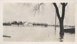
Flood water over front porch of home, 1916 Flood, Norwood
Photograph shows scene from the 1916 flooding of the Assiniboine River in Norwood, flood water levels high enough to submerge front porch of home on left side of photograph.
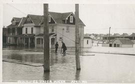
Winnipeg under water - April 1916
Postcard is a photographic print showing water flooding homes likely in St. Boniface. Unknown photographer, Noko mark appears in stamp box.

Flooded residential street, 1916 Flood, Norwood
Photograph shows scene from the 1916 flooding of the Assiniboine River in Norwood, flooded residential street in view.
Homes under water on residential street, 1916 Flood, Norwood
Photograph shows scene from the 1916 flooding of the Assiniboine River in Norwood, homes under water on residential street in view.


Man in boat rowing down residential street, 1916 Flood, Norwood
Photograph shows scene from the 1916 flooding of the Assiniboine River in Norwood, unidentified man rowing down residential street at center-left of photograph.
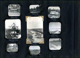
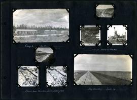
William Smaill Photo Album – Page 29
Part of William Smaill fonds
Captions read: Engineer's camp, Birch River, mile 77 - Sailman's camp, mile 88 - Hospital, mile 77 - Bay City dredge, mile 89 - Pilot ditch, mile 89 - Dyke, Indian Bay - Engineer's camp, mile 88 - Tremblays camp 1 - Mile 85.5, '16.
Smaill, William

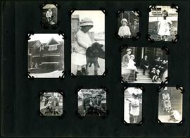
William Smaill Photo Album – Page 46
Part of William Smaill fonds
Captions read: Vera S. - "EH?", "OH?" - Our home at Whitemouth River - Elsie.
Smaill, William
William Smaill Photo Album – Page 90
Part of William Smaill fonds
Captions read: Contains no captions.
Smaill, William

William Smaill Photo Album – Page 37
Part of William Smaill fonds
Captions read: Blaw Forms - Camp 2, Mile 57, Rear View - 8 foot clear muskeg - Camp 2, front view.
Smaill, William
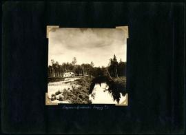
William Smaill Photo Album – Page 55
Part of William Smaill fonds
Captions read: Engineer's residence, boggy number 1.
Smaill, William
William Smaill Photo Album – Page 58
Part of William Smaill fonds
Captions read: Camp 6, mile 85 - 2 cubic yard bucket in muskeg - Shows how muskeg packs under pads - Big muskeg, mile 90.
Smaill, William