- i03896
- Item
- 1940s
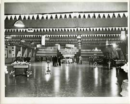
A car show likely held at the Civic Auditorium on Vaughan Street. Several cars are on display from brands such as Hudson and Austin.
A car show likely held at the Civic Auditorium on Vaughan Street. Several cars are on display from brands such as Hudson and Austin.
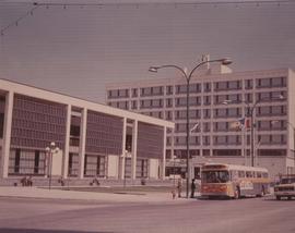
A photograph of the Civic Centre Complex, Winnipeg's third city hall (1964-present). Council Building, Administration Building, and public transit bus in view. Taken from William Avenue and Main Street, looking northwest. Date of photograph is uncertain, [197-?]. The photographer is likely Henry Kalen.
Kalen, Henry

Clark’s Department Store at Highway 59 panorama
View of Clarks at Highway 59, southwest corner of Panet Road and Nairn Avenue, 8.5 acres. From left to right: B/A gas bar, Loblaws, Clarks Discount Store and Auto Centre, B/A gas bar, Kavanaugh's Hamburgers. Consists of 3 separate photographs pasted together on cardboard to create a panorama. The cardboard is a scrap made from an old sign of the Metropolitan Corporation of Greater Winnipeg (visible on the reverse). The cardboard is numbered “4”, presumably as part of a compilation with other shopping centre panoramas.
Metropolitan Corporation of Greater Winnipeg (Man.). Planning Division
![CNR Yards [Aerial view]](/uploads/r/city-of-winnipeg-archives-amp-records-control-branch/3/a/c/3acce1afab65125da800d4ce81f386345349a1e9b9021d949ebfd6c8147f2db0/C0013_0000_0000_P0018_0044_001_142.jpg)
Inscription (on recto): WG M35: 3-8, 5 Mar '45, CNR Yards Wpg, appr scale 1/12000.
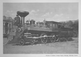
Countess of Dufferin, Pioneer Engine, Winnipeg, Manitoba
Print of a photographic image of the pioneer train engine Countess of Dufferin. Date of print is uncertain, [193-?].
![C.P.R. Yards looking West [Aerial view]](/uploads/r/city-of-winnipeg-archives-amp-records-control-branch/1/d/2/1d24b0471a50903dd76276838a7e169e4890a17020a9cfe6a0d34e153ebb9ec9/C0013_0000_0000_P0018_0027_001_142.jpg)
C.P.R. Yards looking West [Aerial view]
Inscription (on recto): WG A114 30-2-42 CPR [Canadian Pacific Railway] RR [Railroad] Yards looking West.

Crane and David, Bakers and Confectioners
Staff standing in front of Crane and David Bakers and Confectioners at 765 Dufferin Avenue and a horse-drawn delivery cart.

Crestview Shopping Centre panorama
View of Crestview Shopping Centre, 3395 Portage Avenue, 8.3 acres. From left to right: Kmart Department Store, Dominion Store, Various Shops. Consists of 3 separate photographs pasted together on cardboard to create a panorama. The cardboard is a scrap made from an old sign of the Metropolitan Corporation of Greater Winnipeg (visible on the reverse). The cardboard is numbered “9”, presumably as part of a compilation with other shopping centre panoramas.
Metropolitan Corporation of Greater Winnipeg (Man.). Planning Division

Crossroads Shopping Centre panorama
View of Crossroads Shopping Centre, 1580 Regent Avenue W., 18 acres. From left to right: Woolco Department Store, Various shops, Safeway, Pacific 66 Gas Bar. Consists of 3 separate photographs pasted together on cardboard to create a panorama. The cardboard is a scrap made from an old sign of the Metropolitan Corporation of Greater Winnipeg (visible on the reverse). The cardboard is numbered “3”, presumably as part of a compilation with other shopping centre panoramas.
Metropolitan Corporation of Greater Winnipeg (Man.). Planning Division

Dakota Village Shopping Centre panorama
View of Dakota Village Shopping Centre, 1077-1095 St. Mary's Road, 3.5 acres. From left to right: unknown stores, Ladies and Children's Wear, Lance Pharmacy, [Dakota?] Bowling, Shoe Fair, Bank of Nova Scotia, Safeway, apartment block, Bank of Montreal. Consists of 3 separate photographs pasted together on cardboard to create a panorama. The cardboard is a scrap made from an old sign of the Metropolitan Corporation of Greater Winnipeg (visible on the reverse). The cardboard is numbered “6”, presumably as part of a compilation with other shopping centre panoramas.
Metropolitan Corporation of Greater Winnipeg (Man.). Planning Division

Delivery Truck, Lake of the Woods Milling Company
A delivery truck belonging to the Lake of the Woods Milling Company (later known as Five Roses Flour and merged with the Ogilvie Milling Company in 1954), which was based in Keewatin, Ontario.
Entrance to Winnipeg and Parliament Buildings
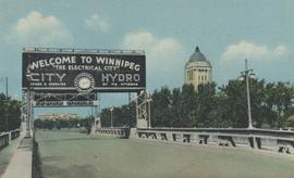
Postcard shows Osborne Street bridge, looking north. Sign over bridge says, "Welcome to Winnipeg, The Electrical City. City Hydro, Owned and Operated by its Citizens". Date of postcard is approximate, ca. 1940.

Foot of Water Street, C.N.R. Bridge - the Flood
Photograph is one of five photos mounted on page with caption "Assiniboine River flooded, Spring 1916."
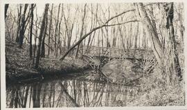
Photograph shows footbridge in wooded area, taken during the fall season. One of three photos mounted on page with caption "Scenes - Kildonan Park." Date of photograph is probable, [1923?].

Footbridge over Assiniboine River to City Park, Sunday afternoon
Date of photograph is approximate, ca. 1914.

Grant Plaza Shopping Centre panorama
View of Grant Park Plaza Shopping Centre, 1200-1216 Grant Avenue, 13.2 acres. From left to right: Clarks Discount Store, Dominion Store, Liquor Commission, Clarks Auto Centre. Consists of 3 separate photographs pasted together on cardboard to create a panorama. The cardboard is a scrap made from an old sign of the Metropolitan Corporation of Greater Winnipeg (visible on the reverse). The cardboard is numbered “8”, presumably as part of a compilation with other shopping centre panoramas.
Metropolitan Corporation of Greater Winnipeg (Man.). Planning Division
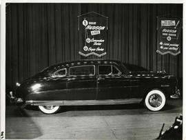
A Hudson brand car on display at a car show likely held in the Civic Auditorium on Vaughan Street. Banners advertiseing the Commodre and Super Series cars hang above.
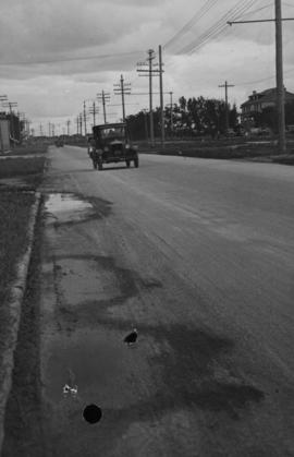
Main Street - Hartford to Belmont, 48 hours after rain
Date of photograph is July 1, 1932.
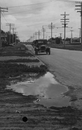
Main Street - Perth to Hartford, Rainfall, June 29, 1932
Photograph is dated July 1, 1932.