
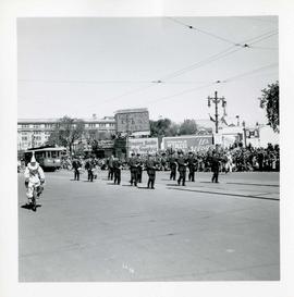
Winnipeg's 75th Anniversary parade - marching band and street car
- i04260
- Pièce
- 6 Jun. 1949
Fait partie de City of Winnipeg Archives Photograph collection
Winnipeg's 75th Anniversary parade - marching band and street car
Fait partie de City of Winnipeg Archives Photograph collection
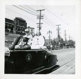
Winnipeg's 75th Anniversary parade - crowned woman in car
Fait partie de City of Winnipeg Archives Photograph collection
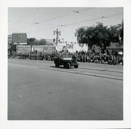
Winnipeg's 75th Anniversary parade - car with skull and crossbones labelled "Dunc Johnny"
Fait partie de City of Winnipeg Archives Photograph collection
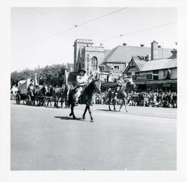
Winnipeg's 75th Anniversary parade - boy on horseback waving
Fait partie de City of Winnipeg Archives Photograph collection
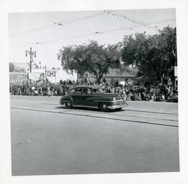
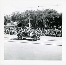
Winnipeg's 75th Anniversary parade - unmarked car
Fait partie de City of Winnipeg Archives Photograph collection
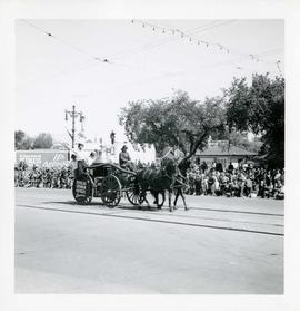
Winnipeg's 75th Anniversary parade - horse drawn fire engine
Fait partie de City of Winnipeg Archives Photograph collection
Float advertises Douglas Chisholm Agencies Insurance
Winnipeg's 75th Anniversary parade - Parade Marshal
Fait partie de City of Winnipeg Archives Photograph collection
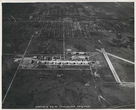
Aerial view of Stevenson Field looking South (Winnipeg Airport)
Fait partie de City of Winnipeg Archives Photograph collection
Inscription (on recto): 5A0S AP13 6-6-42 Stevenson Field looking South.
![CNR Yards [Aerial view]](/uploads/r/city-of-winnipeg-archives-amp-records-control-branch/3/a/c/3acce1afab65125da800d4ce81f386345349a1e9b9021d949ebfd6c8147f2db0/C0013_0000_0000_P0018_0044_001_142.jpg)
Fait partie de City of Winnipeg Archives Photograph collection
Inscription (on recto): WG M35: 3-8, 5 Mar '45, CNR Yards Wpg, appr scale 1/12000.

Scrapbook of Corporal Wallace – page 2
Fait partie de City of Winnipeg Archives Photograph collection
Page 2 of a photograph scrapbook made by Corporal John Wallace in April 1940. Photos consist of Portage Avenue looking west from around Vaughn Street, a rail line at Portage Avenue and St. James Street, troops in formation, and Mrs. and Shirley Gardiner. See general notes section for more details.
Sans titre

Winnipeg Electric Co. trolley bus
Fait partie de City of Winnipeg Archives Photograph collection
Photograph shows people waiting to board electric trolley bus (Winnipeg Electric Company), southbound Garry Street at Portage Avenue. Destination sign reads, No. 73 Sargent, Valour Road. Lindsay Building in background.

Storefronts on Portage Avenue between Carlton and Hargrave Streets
Fait partie de City of Winnipeg Archives Photograph collection
Cars and shoppers in front of stores on the north side of Portage Avenue, between Carlton and Hargrave Streets. Featured are The Berryhill Shoe Store in the Enderton / Mitchell-Copp Building, the Bank of Montreal, and Zeller's (Zellers).

Portage Avenue looking west from Colony Street
Fait partie de City of Winnipeg Archives Photograph collection
A view of Portage Avenue looking west from Colony Street. The Hudson's Bay Company Building is featured prominantly and the Power Building is visible farther west. Playing "Young Mr. Lincoln", the Gaiety Theatre can be seen across the street with two poli

Northdale Shopping Centre panorama
Fait partie de City of Winnipeg Archives Photograph collection
View of Northdale Shopping Centre, 963 Henderson Highway, 7.65 acres. From left to right: Loblaws Groceteria, Zeller's County Fair, various shops, the Royal Bank, the Canadian Imperial Bank of Commerce, A & P Food Store, Lord Wolseley School. Consists of 3 separate photographs pasted together on cardboard to create a panorama. The cardboard is a scrap made from an old sign of the Metropolitan Corporation of Greater Winnipeg (visible on the reverse). The cardboard is numbered “1”, presumably as part of a compilation with other shopping centre panoramas.
Sans titre

Crossroads Shopping Centre panorama
Fait partie de City of Winnipeg Archives Photograph collection
View of Crossroads Shopping Centre, 1580 Regent Avenue W., 18 acres. From left to right: Woolco Department Store, Various shops, Safeway, Pacific 66 Gas Bar. Consists of 3 separate photographs pasted together on cardboard to create a panorama. The cardboard is a scrap made from an old sign of the Metropolitan Corporation of Greater Winnipeg (visible on the reverse). The cardboard is numbered “3”, presumably as part of a compilation with other shopping centre panoramas.
Sans titre

Clark’s Department Store at Highway 59 panorama
Fait partie de City of Winnipeg Archives Photograph collection
View of Clarks at Highway 59, southwest corner of Panet Road and Nairn Avenue, 8.5 acres. From left to right: B/A gas bar, Loblaws, Clarks Discount Store and Auto Centre, B/A gas bar, Kavanaugh's Hamburgers. Consists of 3 separate photographs pasted together on cardboard to create a panorama. The cardboard is a scrap made from an old sign of the Metropolitan Corporation of Greater Winnipeg (visible on the reverse). The cardboard is numbered “4”, presumably as part of a compilation with other shopping centre panoramas.
Sans titre

Grant Plaza Shopping Centre panorama
Fait partie de City of Winnipeg Archives Photograph collection
View of Grant Park Plaza Shopping Centre, 1200-1216 Grant Avenue, 13.2 acres. From left to right: Clarks Discount Store, Dominion Store, Liquor Commission, Clarks Auto Centre. Consists of 3 separate photographs pasted together on cardboard to create a panorama. The cardboard is a scrap made from an old sign of the Metropolitan Corporation of Greater Winnipeg (visible on the reverse). The cardboard is numbered “8”, presumably as part of a compilation with other shopping centre panoramas.
Sans titre

Crestview Shopping Centre panorama
Fait partie de City of Winnipeg Archives Photograph collection
View of Crestview Shopping Centre, 3395 Portage Avenue, 8.3 acres. From left to right: Kmart Department Store, Dominion Store, Various Shops. Consists of 3 separate photographs pasted together on cardboard to create a panorama. The cardboard is a scrap made from an old sign of the Metropolitan Corporation of Greater Winnipeg (visible on the reverse). The cardboard is numbered “9”, presumably as part of a compilation with other shopping centre panoramas.
Sans titre

Northgate Shopping Centre panorama
Fait partie de City of Winnipeg Archives Photograph collection
View of Northgate Plaza Shopping Centre, 1375-1425 McPhillips Street, 15 acres. From left to right: Clarks Discount Store, Various Shops, Northgate Bowling Lanes, Loblaw's. Consists of 3 separate photographs pasted together on cardboard to create a panorama. The cardboard is a scrap made from an old sign of the Metropolitan Corporation of Greater Winnipeg (visible on the reverse). The cardboard is numbered “14”, presumably as part of a compilation with other shopping centre panoramas.
Sans titre

Polo Park Shopping Centre panorama
Fait partie de City of Winnipeg Archives Photograph collection
View of Polo Park Shopping Centre, 1485 Portage Avenue, 41 acres. West side of shopping centre, north side of Portage Avenue between Empress Street and St. James Street. Left to Right: Winnipeg Stadium, Winnipeg Arena, Loblaws, Simpson Sears Marina, Simpson Sears Garden Shop, Simpson Sears Department Store, Simpson Sears Service Station. Consists of 4 separate photographs pasted together on cardboard to create a panorama. The cardboard is a scrap made from an old sign of the Metropolitan Corporation of Greater Winnipeg (visible on the reverse). The cardboard is numbered “11”, presumably as part of a compilation with other shopping centre panoramas.
Sans titre