
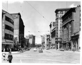
Portage Avenue and Main Street looking north
- i02337
- Item
- 1941
140 results with digital objects Show results with digital objects
Portage Avenue and Main Street looking north

Portage Avenue looking west from Colony Street
A view of Portage Avenue looking west from Colony Street. The Hudson's Bay Company Building is featured prominantly and the Power Building and the Boyd Building are visible farther west.

Thoroughfares: Academy Road at Wellington Crescent
View of cars and cyclists heading down Academy Road towards Wellington Crescent and the Maryland Bridge. The cupola of Misericordia Hospital can be seen across the bridge.
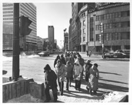
Caption (on file): "Shivering on the corner of Portage and Main on a cold, windy day waiting for traffic lights to change will now be just a memory with the opening of a climate controlled underground pedestrian concourse linking the four corners of Winnipeg's famous intersection."
Allan, Hugh

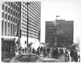
Aerial view of intersection at Portage Avenue and Main Street
Photograph shows aerial view of intersection at Portage Avenue and Main Street (after barriers closing intersection to pedestrian concourse). Also shows Bank of Nova Scotia (Trizec Building) under construction. Photograph likely taken from the top of the Richardson Building.
Allan, Hugh
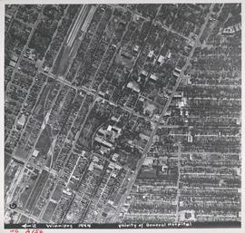
Aerial view of Vicinity of General Hospital, 1944
Description (on recto): WG A156, vicinity of General Hospital, Winnipeg, 1944. - Area around William Avenue and Sherbrook Street shown in photograph. - Photo credit: Royal Canadian Air Force Photograph.
![Logan Avenue and Main Street [Aerial view]](/uploads/r/city-of-winnipeg-archives-amp-records-control-branch/d/9/2/d92728eee72f0ac3b14bbb8ea8f04c5d3ece08f19538ee5d078eb79492de602b/C0013_0000_0000_P0018_0034_001_142.jpg)
Logan Avenue and Main Street [Aerial view]
Inscription (on recto): A160 3-9-43 Logan Ave and Main St Wpg [Winnipeg] about 4000' 5".

Colony Street and Whitehall Avenue
Photograph is one of five photos mounted on page with caption "Assiniboine River flooded, Spring 1916."
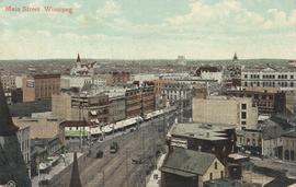
Postcard shows a view of Main Street from Portage Avenue looking north. Published by Valentine & Sons' Publishing Co., Ltd. Montreal and Toronto. Printed in Great Britain. Date of postcard is uncertain.

New boulevards on street north from Palmerston Avenue.
View of new boulevards on an unidentified street in the Wolseley area, facing north from Palmerston Avenue.
Photographs of beautification efforts on Provencher Boulevard.

Part of City of Winnipeg (1874-1971)
A photograph of Higgins Avenue during the 1950 flood. A bridge over the swollen Red River can also be seen.
Harold K. White Studio

Part of City of Winnipeg (1874-1971)
Photograph shows the North End Farmer's Market (west side Main Street, north of Stella Avenue, looking west to King Street). Included in photograph: front entrance to market, automobiles parked on street, and North End Horse Exchange (523 King Street). Photograph likely taken from 919-921 Main Street by city employee.

Part of City of Winnipeg (1874-1971)
Photograph of the Winnipeg Renovating Co. and the Grain Exchange on Lombard Avenue. Item is part of small album containing photographs of maps tracking the outbreak of typhoid from 1905 to 1908 and other scenes. Item is loose and at back of album. Date of item is approximate, [circa 1909].

Part of City of Winnipeg (1874-1971)
Photograph of the Winnipeg Renovating Co. on Lombard Avenue. Item is part of small album containing photographs of maps tracking the outbreak of typhoid from 1905 to 1908 and other scenes. Item is loose and at back of album. Date of item is approximate, [circa 1909].

Mini-park on Academy Road at Kenaston Boulevard
Photograph of a small park at the intersection of Academy Road and Kenaston Boulevard after Metro's beautification efforts, featuring trees, benches, and a water feature. A description of the photo used for publication is recorded on a separate piece of paper. Photo's reverse is stamped by the Parks and Protection Division of the Metro Government.
Metropolitan Corporation of Greater Winnipeg (Man.). Information Officer
Scenes from around St. James and the St. James Bridge
Consists of several photos of the area around the St. James Bridge and includes small parks and green spaces, and the St. James Shopping Centre on Portage Avenue near Moray Street. Photographer is unknown.
Metropolitan Corporation of Greater Winnipeg (Man.). Information Officer
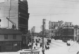
Winnipeg Street Railway on Portage Avenue in front of Merchants Hotel

Main Street, south of Seven Oaks, 48 hours after rain
Date of photograph is July 8, 1932.