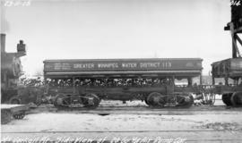
Photograph of the side of a Greater Winnipeg Water District 20 cubic yard dump car at the McCorkell Pit, west of Ostenfeld, Manitoba. Photographer is unknown.
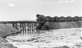
Photograph of dump cars filling in last gap of a cofferdam between dykes at the intake of the Winnipeg Aqueduct at Indian Bay, taken from the west dyke. Photographer is unknown.
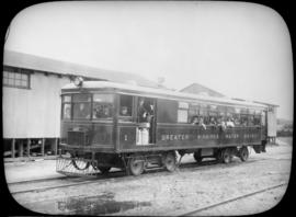
Glass lantern slides taken by L.B. [Lewis Benjamin] Foote of the tourists taking the Greater Winnipeg Water District Railway to and enjoying leisure time at Shoal Lake. The Greater Winnipeg Water District hired Foote to take these photos.
Photograph of a footbridge across the La Salle River in La Barriere Park. A description of the photo used for publication is recorded on a separate piece of paper. Photo's reverse is stamped by the Parks and Protection Division of the Metro Government.
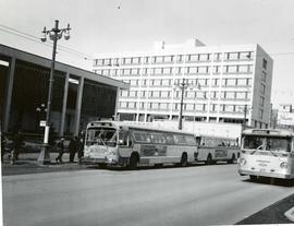
Photograph of several buses in front of City Hall. One, bound for Portage Avenue and Polo Park, is picking up passengers. The photo is marked "One-way Street" and includes a cut line that reads "...gave way to the new". On the photo's reverse, the make and model of the bus is detailed as follows: Make - GMC, Model - TDH 5301, Year - 1960, Seat Capacity - 51. Photographer is unknown.
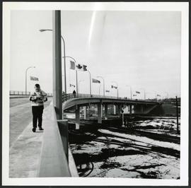
Photograph of people walking across the Nairn Overpass with snow on the ground below. The overpass is lined with flags. Photographed by Gunter A. Schoch, Landscape Architect for the Metro Parks and Protection Division.
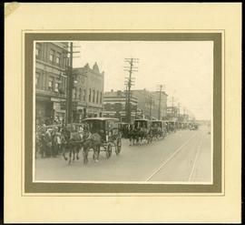
Photograph mounted on cardboard of a cavalcade of Canada Bread horse-drawn delivery wagons riding south down Main Street, at the corner of Selkirk Avenue.
A promotional map created by the Publicity Bureau of Winnipeg and Manitoba titled "For Your Guidance While in Winnipeg". Map was originally folded as a pamphlet, the front page of which features a graphic of two people driving down Highway 14 (now Highway 75) to Winnipeg. The map is not scale and features cartoon depictions of tourist destinations and landmarks around Winnipeg and St. Boniface. The maps shows major streets, railroads, and street railway lines. The map side was originally framed and cut to fit. At a result a small part of the front page is cut off, including a stamp reading "St. Raphael's Ukrainian Immigrants' Welfare Association of Can[ada]".
Photograph shows old St. James Bridge approach, looking north up Madison Street (now Century Street/Route 90). Present Viscount Gort site in center. Date of photograph is uncertain, [after 1932].