
![C.P.R. Yards looking West [Aerial view]](/uploads/r/city-of-winnipeg-archives-amp-records-control-branch/1/d/2/1d24b0471a50903dd76276838a7e169e4890a17020a9cfe6a0d34e153ebb9ec9/C0013_0000_0000_P0018_0027_001_142.jpg)
C.P.R. Yards looking West [Aerial view]
- i01911
- Pièce
- 1942
Fait partie de City of Winnipeg Archives Photograph collection
Inscription (on recto): WG A114 30-2-42 CPR [Canadian Pacific Railway] RR [Railroad] Yards looking West.
33 résultats avec objets numériques Afficher les résultats avec des objets numériques
C.P.R. Yards looking West [Aerial view]
Fait partie de City of Winnipeg Archives Photograph collection
Inscription (on recto): WG A114 30-2-42 CPR [Canadian Pacific Railway] RR [Railroad] Yards looking West.
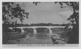
The Foot Bridge in City Park, Winnipeg, Manitoba
Fait partie de City of Winnipeg Archives Photograph collection
Photograph shows the foot bridge across the Assiniboine River in City Park. Date of photograph is approximate, ca. 1940.
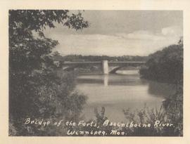
Bridge of the Forts, Assiniboine River, Winnipeg, Man.
Fait partie de City of Winnipeg Archives Photograph collection
Date of photograph is approximate, ca. 1940.
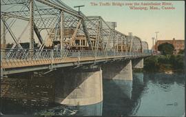
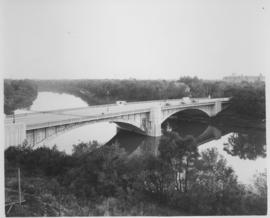
The Traffic Bridge over the Assiniboine River, Winnipeg
Fait partie de City of Winnipeg Archives Photograph collection
Date of postcard is uncertain, [before 1949].
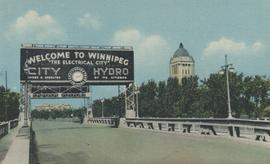
Entrance to Winnipeg and Parliament Buildings
Fait partie de City of Winnipeg Archives Photograph collection
Postcard shows Osborne Street bridge, looking north. Sign over bridge says, "Welcome to Winnipeg, The Electrical City. City Hydro, Owned and Operated by its Citizens". Date of postcard is approximate, ca. 1940.

No. 8 A portion of the Lyndale dike in Norwood with the Norwood Bridge in the background
Fait partie de City of Winnipeg Archives Photograph collection
Photograph shows scene from 1950 flood. Description (on verso): Note the roof of the Greater Winnipeg Sanitary District Marion Street pumping station on the right. Stamp (on verso): City of Winnipeg - Engineering Dept., Water Works Division, Ross and Tecumseh.

Fait partie de City of Winnipeg Archives Photograph collection
Photograph shows old St. James Bridge approach, looking North up present Kintrye Street. Viscount Gort site centre right/Hydro sub-station - St. James Street and Portage Avenue far left. Date of photograph is uncertain [after 1932].

Fait partie de City of Winnipeg Archives Photograph collection
Photograph shows old St. James Bridge approach, looking north up Madison Street (now Century Street/Route 90). Present Viscount Gort site in center. Date of photograph is uncertain, [after 1932].
Fait partie de City of Winnipeg Archives Photograph collection
Photograph shows Maryland Street Bridge looking southeast into Crescentwood. Date of photograph is approximate, ca. 1925.

Fait partie de City of Winnipeg (1874-1971)
A photograph of a flooded underpass on Higgins Avenue during the 1950 flood.
Sans titre

Fait partie de City of Winnipeg (1874-1971)
A photograph of children on Higgins Avenue during the 1950 flood. Piles of earth and sandbags line the street.
Sans titre

Fait partie de City of Winnipeg (1874-1971)
A photograph of Higgins Avenue during the 1950 flood. A bridge over the swollen Red River can also be seen.
Sans titre

Pontoon Bridge, Fort Garry and Warehouse from south side Assiniboine River
Fait partie de City of Winnipeg (1874-1971)
Fait partie de Parks and Recreation Photograph collection
Photographs of the opening of the Nairn Overpass and green space near it.
Fait partie de Metropolitan Corporation of Greater Winnipeg
Photographs of overpasses and areas of the Greater Winnipeg Area for which overpasses were proposed.
Sans titre
Fait partie de Metropolitan Corporation of Greater Winnipeg
Photographs of the Nairn Overpass, including its construction and dedication.
Sans titre