
- i03544
- Pièce
- 1927
Fait partie de City of Winnipeg (1874-1971)
Sans titre
42 résultats avec objets numériques Afficher les résultats avec des objets numériques
Fait partie de City of Winnipeg (1874-1971)
Sans titre

Fait partie de City of Winnipeg (1874-1971)
Photograph shows the North End Farmer's Market (west side Main Street, north of Stella Avenue, looking west to King Street). Included in photograph: front entrance to market, automobiles parked on street, and North End Horse Exchange (523 King Street). Photograph likely taken from 919-921 Main Street by city employee.

Fait partie de City of Winnipeg (1874-1971)
Photograph shows the North End Farmer's Market, looking east across Main Street (northwest Main Street and Stella Avenue). Included in photograph: stalls filled with vegetables and people walking through the market, Aime Bicycle Shop, 909 Main Street, two-storey brick building (899-905 Main Street), and Norquay School.

1932 Relief Works and Committee Winnipeg
Fait partie de City of Winnipeg Archives Photograph collection
Photograph collage of the 1932 Winnipeg Relief Works and Committee. Portraits of committee members are surrounding photographs of projects the committee had worked on. The committee members are, clockwise from top left: Alderman John Blumberg, Alderman H. Andrews, City Clerk Magnus Peterson, Alderman J.A. Barry, Alderman A.A. Ryley, Alderman W.B. Simpson, City Engineer W.P. Brereton, G.W. Northwood, Alderman E.D. Honeyman, Mayor Ralph Webb, Alderman J.A. McKerschar, A. MacNamara, Resident Engineer A.J. Taunton, Alderman L.F. Borrowman, and Alderman C.E. Simonite. The works projects showcased in the center are, clockwise from top left: the Main Street Bridge, the Norwood Bridge, the Assiniboine Park Bridge, the Winnipeg Auditorium, the Sargent Park Swimming Pool, and the Salter Street Bridge. Created by Robson Photo.
![C.P.R. Yards looking West [Aerial view]](/uploads/r/city-of-winnipeg-archives-amp-records-control-branch/1/d/2/1d24b0471a50903dd76276838a7e169e4890a17020a9cfe6a0d34e153ebb9ec9/C0013_0000_0000_P0018_0027_001_142.jpg)
C.P.R. Yards looking West [Aerial view]
Fait partie de City of Winnipeg Archives Photograph collection
Inscription (on recto): WG A114 30-2-42 CPR [Canadian Pacific Railway] RR [Railroad] Yards looking West.
![Logan Avenue and Main Street [Aerial view]](/uploads/r/city-of-winnipeg-archives-amp-records-control-branch/d/9/2/d92728eee72f0ac3b14bbb8ea8f04c5d3ece08f19538ee5d078eb79492de602b/C0013_0000_0000_P0018_0034_001_142.jpg)
Logan Avenue and Main Street [Aerial view]
Fait partie de City of Winnipeg Archives Photograph collection
Inscription (on recto): A160 3-9-43 Logan Ave and Main St Wpg [Winnipeg] about 4000' 5".
![Vicinity of Elmwood Park [Aerial view]](/uploads/r/city-of-winnipeg-archives-amp-records-control-branch/5/b/9/5b929d618c2f619e557788462eee14587693511e7959bc6ca77ae96654d1bc98/C0013_0000_0000_P0018_0041_001_142.jpg)
Vicinity of Elmwood Park [Aerial view]
Fait partie de City of Winnipeg Archives Photograph collection
Inscription (on recto): WG M35: 3-15, 5 Mar '45, vicinity Elmwood Park Wpg, appr. scale 1/12000.
![Vicinity of Elmwood Park [Aerial view]](/uploads/r/city-of-winnipeg-archives-amp-records-control-branch/c/6/d/c6dc0bd0b8c2199f232fe8c7f5245d25e681a6a759be00e013a35a7a1ecada23/C0013_0000_0000_P0018_0042_001_142.jpg)
Vicinity of Elmwood Park [Aerial view]
Fait partie de City of Winnipeg Archives Photograph collection
Inscription (on recto): WG M35: 3-16, 5 Mar '45, vicinity Elmwood Park Wpg, appr scale 1/12000.

Central Business District: Aerial view - Central Winnipeg
Fait partie de City of Winnipeg Archives Photograph collection
Date of photograph is approximate, ca. 1947.
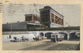
Subway, Main Street North, Winnipeg, Man.
Fait partie de City of Winnipeg Archives Photograph collection
Postcard shows C.P.R. Subway (Canadian Pacific Railway), looking south from Sutherland Avenue. Royal Alexandra Hotel and C.P.R. train sheds in view. Postmarked and note written on back. Date of postcard is uncertain, [before 1949].

Aerial view of Point Douglas, St. Boniface, and Elmwood areas
Fait partie de City of Winnipeg Archives Photograph collection
Aerial photograph of Point Douglas, St. Boniface, and west Elmwood.

Fait partie de City of Winnipeg (1874-1971)
A photograph of the Rover Street hydro station, surrounded by water, during the 1950 flood.
Sans titre

Fait partie de City of Winnipeg (1874-1971)
A photograph of the Rover Street hydro station, surrounded by water, during the 1950 flood. A group of people are walking on the sandbag dike that surrounds the building.
Sans titre
Scrapbook [1950 flood photographs]
Fait partie de City of Winnipeg (1874-1971)
Subseries consists of a scrapbook assembled by the City Engineering Department to serve as photographic evidence of the 1950 flood. It contains black and white photographs that mostly document flooding in residential areas near the Red River (Fort Rouge, Riverview, North End, Point Douglas, Crescentwood, Armstrong's Point and others). Scrapbook appears to be organized geographically by area and street. In addition to documenting flooding, the photographs provide a detailed record of residential neighbourhoods, houses, streets, and businesses like corner grocery stores and laundries. All photographs were taken by Harold K. White Studio.
Sans titre

Northgate Shopping Centre panorama
Fait partie de City of Winnipeg Archives Photograph collection
View of Northgate Plaza Shopping Centre, 1375-1425 McPhillips Street, 15 acres. From left to right: Clarks Discount Store, Various Shops, Northgate Bowling Lanes, Loblaw's. Consists of 3 separate photographs pasted together on cardboard to create a panorama. The cardboard is a scrap made from an old sign of the Metropolitan Corporation of Greater Winnipeg (visible on the reverse). The cardboard is numbered “14”, presumably as part of a compilation with other shopping centre panoramas.
Sans titre

Aerial of 1974 Flood – Pritchard Avenue Boat Dock and Redwood Bridge
Fait partie de City of Winnipeg Archives Photograph collection
Aerial photograph of the Red River during the 1974 Flood. The photograph faces northwest towards the North End, with the Pritchard Avenue Boat Dock in the bottom left and the Redwood Bridge in the top right. The photographs were taken by the Department of Environmental Planning.
Sans titre
Fait partie de City of Winnipeg (1874-1971)
A photograph taken during the 1950 flood, showing 78 Barber Street and 90 Barber Street and 92 Barber Street. Item is 4 of 5 photographs on page 58 of scrapbook.
Sans titre
Fait partie de City of Winnipeg (1874-1971)
A photograph taken during the 1950 flood, showing 96 Barber Street. Item is 5 of 5 photographs on page 58 of scrapbook.
Sans titre
Fait partie de City of Winnipeg (1874-1971)
A photograph taken during the 1950 flood, showing 44 Grove Street and 46 Grove Street. Item is 2 of 8 photographs on page 59 of scrapbook.
Sans titre
Fait partie de City of Winnipeg (1874-1971)
A photograph taken during the 1950 flood, showing 46 Grove Street and 48 Grove Street. Item is 3 of 8 photographs on page 59 of scrapbook.
Sans titre