

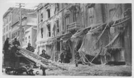
Main Street, south of Seven Oaks, 48 hours after rain
- i01416
- Pièce
- 1932
Fait partie de City of Winnipeg Archives Photograph collection
Date of photograph is July 8, 1932.
Main Street, south of Seven Oaks, 48 hours after rain
Fait partie de City of Winnipeg Archives Photograph collection
Date of photograph is July 8, 1932.
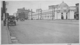
Industrial Bureau Exposition Building
Fait partie de City of Winnipeg Archives Photograph collection
Photograph shows the Industrial Bureau Exposition Building, also called the Board of Trade Building, at Main Street and Water Avenue (now William Stephenson Way). Date of photograph is approximate, ca. 1915.
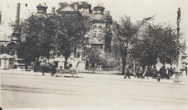
Winnipeg City Hall, Recruiting Stand
Fait partie de City of Winnipeg Archives Photograph collection
Photograph shows Winnipeg's second City Hall (1886-1962) with recruiting stand at lower left: 'Sign Up for Overseas. Volunteer Today, Tomorrow May be too Late.' - Likely taken shortly after the start of World War 1.
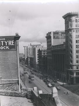
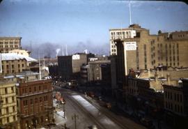
View of Main Street looking north from the Western Canada Loan Building
Fait partie de City of Winnipeg Archives Photograph collection
Photograph shows view of Main Street looking north from the roof of the Western Canada Loan Building, 392 Main Street at Portage Avenue. Date of photograph is approximate, ca. 1935.

Main Street Winnipeg looking south from City Hall
Fait partie de City of Winnipeg Archives Photograph collection
Fait partie de City of Winnipeg Archives Photograph collection
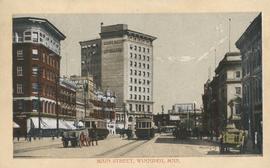
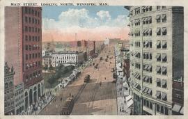
Postcard shows Main Street looking north from McDermot Avenue to Union Bank Building. Date of postcard is uncertain, [before 1949].
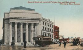
Bank of Montreal, corner of Portage Avenue and Main Street
Fait partie de City of Winnipeg Archives Photograph collection
Date of postcard is approximate, ca. 1912.
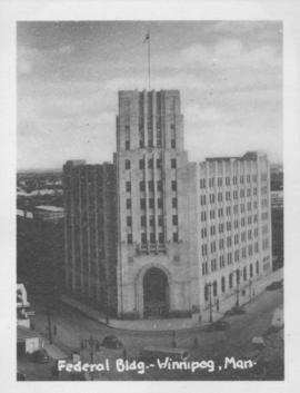
Fait partie de City of Winnipeg Archives Photograph collection
Photograph shows Federal building located on Main Street at Water Avenue.
![Kildonan Park [Aerial view]](/uploads/r/city-of-winnipeg-archives-amp-records-control-branch/f/5/8/f589f26a584950aadbe5b101158e69cde3cad16f0f0cf05dcbb2a97e34661f16/C0013_0000_0000_P0018_0037_001_142.jpg)
Fait partie de City of Winnipeg Archives Photograph collection
Inscription (on recto): WG M35: 2-18, 5 Mar. '45, Kildonan Park, Wpg [Winnipeg], appr. scale 1/12000.
![Vicinity of Elmwood Park [Aerial view]](/uploads/r/city-of-winnipeg-archives-amp-records-control-branch/c/6/d/c6dc0bd0b8c2199f232fe8c7f5245d25e681a6a759be00e013a35a7a1ecada23/C0013_0000_0000_P0018_0042_001_142.jpg)
Vicinity of Elmwood Park [Aerial view]
Fait partie de City of Winnipeg Archives Photograph collection
Inscription (on recto): WG M35: 3-16, 5 Mar '45, vicinity Elmwood Park Wpg, appr scale 1/12000.
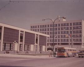
Fait partie de City of Winnipeg Archives Photograph collection
A photograph of the Civic Centre Complex, Winnipeg's third city hall (1964-present). Council Building, Administration Building, and public transit bus in view. Taken from William Avenue and Main Street, looking northwest. Date of photograph is uncertain, [197-?]. The photographer is likely Henry Kalen.
Sans titre
The "Blue Store," Main Street, Winnipeg after fire - January 25, 1918
Fait partie de City of Winnipeg Archives Photograph collection
Main Street, looking north, Winnipeg, Man.
Fait partie de City of Winnipeg Archives Photograph collection
Postcard showing Main Street looking north from Bannatyne Avenue. Date of postcard is unknown.

Corner Portage Avenue and Main Street, Winnipeg, Manitoba
Fait partie de City of Winnipeg Archives Photograph collection
Print is a photographic image of the intersection of Portage Avenue and Main Street. Date of print is uncertain, [193-].
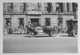
Automobile, clowns, Winnipeg's 75th Anniversary Parade
Fait partie de City of Winnipeg Archives Photograph collection
Photograph shows clowns riding in and on an automobile in front of the Canadian Bank of Commerce on Main Street during Winnipeg's 75th Anniversary Parade.
Fait partie de City of Winnipeg Archives Photograph collection

Fait partie de City of Winnipeg Archives Photograph collection
Photograph shows Winnipeg's second City Hall (1886-1952). Stamp (on verso) credits the photograph to the Geological Survey of Canada, No. 19549. Date of photograph is uncertain, [191-?].

Main Street looking northeast to Grace Methodist Church
Fait partie de City of Winnipeg Archives Photograph collection
Photograph of a muddy Main Street in 1871, facing northeast from around St. Mary Avenue. Featured on the photograph's right-hand side is Grace Methodist Church, located at Main Street and Water Avenue (now William Stephenson Way), which was opened on September 17 of that year.

Aerial view of Point Douglas, St. Boniface, and Elmwood areas
Fait partie de City of Winnipeg Archives Photograph collection
Aerial photograph of Point Douglas, St. Boniface, and west Elmwood.

Photograph album of Winnipeg during WW1: Page 6
Fait partie de City of Winnipeg Archives Photograph collection
Item consists of a scrapbook page showing soldiers marching in military parade on street in front of the Elliott and Hazel Grocers, 975 Main Street and the H. Lindster's Bakery, 971 Main Street (Item 25), soldiers lined up in military parade (Item 26),
soldiers marching in military parade (Item 27), soldiers marching in military parade (Item 28), [ca. 1913].