General Hospital - Winnipeg, Man.
- i01996
- Item
- [ca. 1949]
Item consists of a postcard in printed format that shows the Winnipeg General Hospital. Date of postcard is unknown.
24 results with digital objects Show results with digital objects
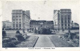
General Hospital - Winnipeg, Man.
Item consists of a postcard in printed format that shows the Winnipeg General Hospital. Date of postcard is unknown.

Thoroughfares: Academy Road at Wellington Crescent
View of cars and cyclists heading down Academy Road towards Wellington Crescent and the Maryland Bridge. The cupola of Misericordia Hospital can be seen across the bridge.

Thoroughfares: Academy Road at Wellington Crescent
View of cars and cyclists heading down Academy Road towards Wellington Crescent and the Maryland Bridge. A small portion of Misericordia Hospital can be seen across the bridge.
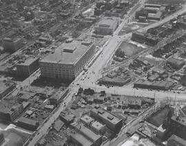
#2, P.R.M., Westminster and Canora - 1947

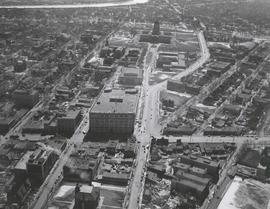
Central Business District: Aerial view - Central Winnipeg
Date of photograph is approximate, ca. 1947.
![Sargent Park [Aerial View]](/uploads/r/city-of-winnipeg-archives-amp-records-control-branch/e/5/1/e51b6ff83bb626c524f2415a4d84c08187de0f175c746cbde40dcf11e700b8eb/C0013_0000_0000_P0018_0039_001_142.jpg)
Inscription (on recto): WG. M35: 5-10, 5 Mar' 45, Sgt Park Vicinity, appr. scale 1/12000.
![Legislative Building and Central Winnipeg [Aerial view]](/uploads/r/city-of-winnipeg-archives-amp-records-control-branch/5/1/1/511af88a9e92fe7d7d3edda2bdaee6fc5652013532efb88411d3403dfcf85917/C0013_0000_0000_P0018_0046_001_142.jpg)
Legislative Building and Central Winnipeg [Aerial view]
Inscription (on recto): WG M35: 4-5, 5 Mar '45, Legislative Bldg and Central Wpg, appr. scale 1/12000.
![Sargent Park vicinity [Aerial view]](/uploads/r/city-of-winnipeg-archives-amp-records-control-branch/6/d/b/6dbefceeef372f0514de159e1569f5aba581dc63a4d454200688557662b9ce22/C0013_0000_0000_P0018_0038_001_142.jpg)
Sargent Park vicinity [Aerial view]
Inscription (on recto): WG M35: 5-9, 5 Mar. '45, Sgt Park Vicinity, appr. scale 1/12000.
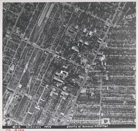
Aerial view of Vicinity of General Hospital, 1944
Description (on recto): WG A156, vicinity of General Hospital, Winnipeg, 1944. - Area around William Avenue and Sherbrook Street shown in photograph. - Photo credit: Royal Canadian Air Force Photograph.

Aerial view of RCAF Equipment Depot Number 2
Aerial photograph showing the Royal Canadian Air Force Equipment Depot Number 2, south of Brooklands and Weston. The Weston Shops are featured at the top of the photograph. The Inscription (on recto): NE. WG. F24 AP144 49.55N 97.07W #7 Equip. Depot Wpg [Winnipeg], 14-3-44, 15:00, 8" 2500'.
![Logan Avenue and Salter Street [Aerial view]](/uploads/r/city-of-winnipeg-archives-amp-records-control-branch/9/8/0/980f8ba4214d821c9b49366ae35d9ea9ed5b7f44366c5cd894e04befdd6c7a22/C0013_0000_0000_P0018_0033_001_142.jpg)
Logan Avenue and Salter Street [Aerial view]
Inscription (on recto): A161 3-9-43 Logan Ave and Salter St Wp [Winnipeg?] about 4000' 5".
![Central Winnipeg between Portage and Notre Dame Avenues [Aerial view]](/uploads/r/city-of-winnipeg-archives-amp-records-control-branch/e/3/f/e3f90f80ff2b9d7dc2938509d7f4a5b4dfdfef9308ecfc0cfa38d5f1e2aa0bb8/C0013_0000_0000_P0018_0026_001_142.jpg)
Central Winnipeg between Portage and Notre Dame Avenues [Aerial view]
Inscription (on recto): WG A158 8/6/1942 Central Wpg between Portage and Notre Dame Ave's.
![C.P.R. Yards looking West [Aerial view]](/uploads/r/city-of-winnipeg-archives-amp-records-control-branch/1/d/2/1d24b0471a50903dd76276838a7e169e4890a17020a9cfe6a0d34e153ebb9ec9/C0013_0000_0000_P0018_0027_001_142.jpg)
C.P.R. Yards looking West [Aerial view]
Inscription (on recto): WG A114 30-2-42 CPR [Canadian Pacific Railway] RR [Railroad] Yards looking West.
![Northwest Winnipeg [Aerial view]](/uploads/r/city-of-winnipeg-archives-amp-records-control-branch/4/f/3/4f37bff68f08b53a6e7296217f26c266711570595702620b7b89d115744d09e4/C0013_0000_0000_P0018_0025_001_142.jpg)
Northwest Winnipeg [Aerial view]
Aerial view of the Minto area. Inscription (on recto): WG A90 '41, 1941 - Northwest Winnipeg.
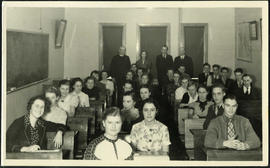
Jon Bjarnason Academy – grade 12 class and faculty
Group photograph of the 1937-38 grade 12 class at Jon Bjarnason Academy (652 Home Street), seated in their desks with faculty standing behind them.
Aerial view looking south from over Wesley Park at rear of United College
Date of photograph is approximate, ca. 1937.

Aerial view of Winnipeg looking south on Memorial Boulevard toward Legislative Building
Date of photograph is approximate, ca. 1935.

1932 Relief Works and Committee Winnipeg
Photograph collage of the 1932 Winnipeg Relief Works and Committee. Portraits of committee members are surrounding photographs of projects the committee had worked on. The committee members are, clockwise from top left: Alderman John Blumberg, Alderman H. Andrews, City Clerk Magnus Peterson, Alderman J.A. Barry, Alderman A.A. Ryley, Alderman W.B. Simpson, City Engineer W.P. Brereton, G.W. Northwood, Alderman E.D. Honeyman, Mayor Ralph Webb, Alderman J.A. McKerschar, A. MacNamara, Resident Engineer A.J. Taunton, Alderman L.F. Borrowman, and Alderman C.E. Simonite. The works projects showcased in the center are, clockwise from top left: the Main Street Bridge, the Norwood Bridge, the Assiniboine Park Bridge, the Winnipeg Auditorium, the Sargent Park Swimming Pool, and the Salter Street Bridge. Created by Robson Photo.