
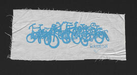
The W.R.E.N.C.H. bike pile logo screen print
- i04787
- Item
- 2015
Part of The W.R.E.N.C.H. Winnipeg Cycling Archive collection
Art by Laura Tait.
The W.R.E.N.C.H.
109 results with digital objects Show results with digital objects
The W.R.E.N.C.H. bike pile logo screen print
Part of The W.R.E.N.C.H. Winnipeg Cycling Archive collection
Art by Laura Tait.
The W.R.E.N.C.H.

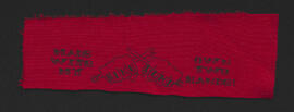
The W.R.E.N.C.H. volunteer screen print
Part of The W.R.E.N.C.H. Winnipeg Cycling Archive collection
Art by Laura Tait.
The W.R.E.N.C.H.

Bike Dump all cyclists are beautiful screen print
Part of The W.R.E.N.C.H. Winnipeg Cycling Archive collection
Artist unknown.
The Bike Dump
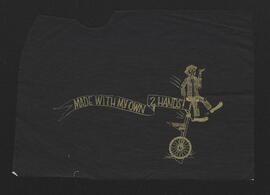
Bike Dump made with my own two hands fists logo screen print
Part of The W.R.E.N.C.H. Winnipeg Cycling Archive collection
Designed by Geoffrey Heath and Camille Metcalfe.
The Bike Dump

W.R.E.N.C.H. logo screen print
Part of The W.R.E.N.C.H. Winnipeg Cycling Archive collection
Art by David Oro.
The W.R.E.N.C.H.
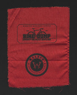
Bike Dump and W.R.E.N.C.H. logos screen print
Part of The W.R.E.N.C.H. Winnipeg Cycling Archive collection
Art by David Oro.
The W.R.E.N.C.H.
Bike Dump made with my own two hands unicycle logo screen print
Part of The W.R.E.N.C.H. Winnipeg Cycling Archive collection
Art by Camille Metcalfe.
The Bike Dump

University of Winnipeg Students Association Bike Lab logo screen print
Part of The W.R.E.N.C.H. Winnipeg Cycling Archive collection
Artist unknown.
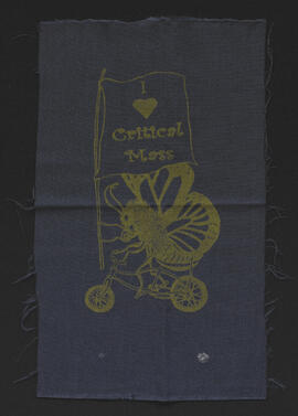
I heart Critical Mass screen print
Part of The W.R.E.N.C.H. Winnipeg Cycling Archive collection
Design adapted from a Beehive Collective art piece by Juan Martinez.
Critical Mass Winnipeg
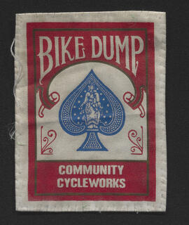
Bike Dump bicycle card logo screen print
Part of The W.R.E.N.C.H. Winnipeg Cycling Archive collection
Art by Paul Phillips.
The Bike Dump
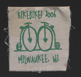
Bike!Bike! 2006 Milwaukee, WI screen print
Part of The W.R.E.N.C.H. Winnipeg Cycling Archive collection
Artist unknown.
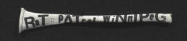
Rat Patrol Winnipeg screen print
Part of The W.R.E.N.C.H. Winnipeg Cycling Archive collection
Artist unknown.

City of Winnipeg bicycle license plate
Part of The W.R.E.N.C.H. Winnipeg Cycling Archive collection

Dakota Village Shopping Centre panorama
View of Dakota Village Shopping Centre, 1077-1095 St. Mary's Road, 3.5 acres. From left to right: unknown stores, Ladies and Children's Wear, Lance Pharmacy, [Dakota?] Bowling, Shoe Fair, Bank of Nova Scotia, Safeway, apartment block, Bank of Montreal. Consists of 3 separate photographs pasted together on cardboard to create a panorama. The cardboard is a scrap made from an old sign of the Metropolitan Corporation of Greater Winnipeg (visible on the reverse). The cardboard is numbered “6”, presumably as part of a compilation with other shopping centre panoramas.
Metropolitan Corporation of Greater Winnipeg (Man.). Planning Division

Rossmere Shopping Centre panorama
View of Rossmere Shopping Centre, 1070 Henderson Highway, southwest corner Rowandale, 4.25 acres. From left to right: a garage or car wash, Red River Co-Op Store, Rossmere Lanes Bowling Alley, Library, Dry Cleaners, Co-operators Credit Union Society Limited, Rowandale Baptist Church, Rowandale Apartments, Red River Co-Op Gas Station. Consists of 3 separate photographs pasted together on cardboard to create a panorama. The cardboard is a scrap made from an old sign of the Metropolitan Corporation of Greater Winnipeg (visible on the reverse). The cardboard is numbered “2”, presumably as part of a compilation with other shopping centre panoramas.
Metropolitan Corporation of Greater Winnipeg (Man.). Planning Division

Southgate Shopping Centre panorama
View of Southgate Village Shopping Centre, 1305-1341 Pembina Highway at the southwest corner of McGillivray Boulevard, 3.3 acres. From left to right: Pembina Curling Rink, Imperial Cleaners, Safeway, The Place, Young Togs, Reid Marshall Pharmacy, The Village Gift Shop, The French Salon, Marshall Wells, The Toronto Dominion Bank, Safeway gas bar. Consists of 3 separate photographs pasted together on cardboard to create a panorama. The cardboard is a scrap made from an old sign of the Metropolitan Corporation of Greater Winnipeg (visible on the reverse). The cardboard is numbered “7”, presumably as part of a compilation with other shopping centre panoramas.
Metropolitan Corporation of Greater Winnipeg (Man.). Planning Division

Westwood Shopping Centre panorama
View of Westwood Shopping Centre, 3276-3332 Portage Avenue, 10.2 acres. From left to right: various shops, motel, various shops and Assiniboia Public Library, Safeway Store, Marshall Wells, Perths, Westwood Pharmacy, various Shops, Zeller's County Fair, Auto Centre. Consists of 3 separate photographs pasted together on cardboard to create a panorama. The cardboard is a scrap made from an old sign of the Metropolitan Corporation of Greater Winnipeg (visible on the reverse). The cardboard is numbered “10”, presumably as part of a compilation with other shopping centre panoramas.
Metropolitan Corporation of Greater Winnipeg (Man.). Planning Division

Northdale Shopping Centre panorama
View of Northdale Shopping Centre, 963 Henderson Highway, 7.65 acres. From left to right: Loblaws Groceteria, Zeller's County Fair, various shops, the Royal Bank, the Canadian Imperial Bank of Commerce, A & P Food Store, Lord Wolseley School. Consists of 3 separate photographs pasted together on cardboard to create a panorama. The cardboard is a scrap made from an old sign of the Metropolitan Corporation of Greater Winnipeg (visible on the reverse). The cardboard is numbered “1”, presumably as part of a compilation with other shopping centre panoramas.
Metropolitan Corporation of Greater Winnipeg (Man.). Planning Division

Crossroads Shopping Centre panorama
View of Crossroads Shopping Centre, 1580 Regent Avenue W., 18 acres. From left to right: Woolco Department Store, Various shops, Safeway, Pacific 66 Gas Bar. Consists of 3 separate photographs pasted together on cardboard to create a panorama. The cardboard is a scrap made from an old sign of the Metropolitan Corporation of Greater Winnipeg (visible on the reverse). The cardboard is numbered “3”, presumably as part of a compilation with other shopping centre panoramas.
Metropolitan Corporation of Greater Winnipeg (Man.). Planning Division

Clark’s Department Store at Highway 59 panorama
View of Clarks at Highway 59, southwest corner of Panet Road and Nairn Avenue, 8.5 acres. From left to right: B/A gas bar, Loblaws, Clarks Discount Store and Auto Centre, B/A gas bar, Kavanaugh's Hamburgers. Consists of 3 separate photographs pasted together on cardboard to create a panorama. The cardboard is a scrap made from an old sign of the Metropolitan Corporation of Greater Winnipeg (visible on the reverse). The cardboard is numbered “4”, presumably as part of a compilation with other shopping centre panoramas.
Metropolitan Corporation of Greater Winnipeg (Man.). Planning Division