

- i01498
- Item
- 1969
Item consists of a report cover for Downtown Winnipeg, created by the Metropolitan Corporation of Greater Winnipeg - Planning Division, April 1, 1969.
Metropolitan Corporation of Greater Winnipeg (Man.). Planning Division
10 results with digital objects Show results with digital objects
Item consists of a report cover for Downtown Winnipeg, created by the Metropolitan Corporation of Greater Winnipeg - Planning Division, April 1, 1969.
Metropolitan Corporation of Greater Winnipeg (Man.). Planning Division

Downtown Winnipeg - Section and Interior View of Winter Garden
Items shows drawing in printed format that record plans for downtown area.
Metropolitan Corporation of Greater Winnipeg (Man.). Planning Division
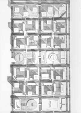
Downtown Winnipeg - Plan of St. Mary-Broadway Sector
Item shows drawing in printed format that records plans for downtown area.
Metropolitan Corporation of Greater Winnipeg (Man.). Planning Division

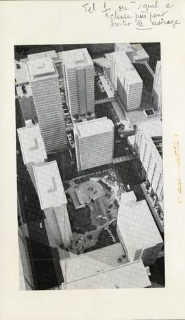
Downtown Winnipeg - Model photo of Downtown Plan (side view)
Item appears to show photographic reproduction of model (side view) in printed format that records plans for downtown area.
Metropolitan Corporation of Greater Winnipeg (Man.). Planning Division
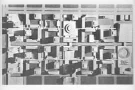
Downtown Winnipeg - Model Photo of Downtown Plan (aerial view)
Item appears to show photographic reproduction of model (aerial view) in printed format that records plans for downtown area.
Metropolitan Corporation of Greater Winnipeg (Man.). Planning Division

Downtown Winnipeg - Isometric of St. Mary-Broadway Sector
Item shows drawing in printed format that records plans for downtown Winnipeg.
Metropolitan Corporation of Greater Winnipeg (Man.). Planning Division

Item is a photographic reproduction of map showing various sewer system details. Stamp (on verso): City of Winnipeg - Engineering Dept., Water Works Division, Ross and Tecumseh.
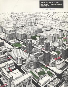
Downtown Winnipeg - Aerial view of St. Mary-Broadway Sector (Map Three)
Items shows drawing in printed format that record plans for downtown area.
Metropolitan Corporation of Greater Winnipeg (Man.). Planning Division
Conceptual plan of the Japanese Garden and surrounding area
Photograph shows a conceptual model of the Japanese Gardens and the area between Carlton and Hargrave Streets, and York and St. Mary Avenues. Most of the buildings in the model were never built and the Japanese Gardens are significantly different than that which currently exists. The photographer is unknown.
Metropolitan Corporation of Greater Winnipeg (Man.). Information Officer

Plan of University section of Tuxedo Park
A map of the proposed Tuxedo Park residential suburb, specifically the area surrounding the old University of Manitoba campus and Olmsted and Assiniboine Parks. The map shows streets and lots as well as details of the university campus. The map was created by Charles Clifton Chataway (1869-1920) and Bulman Brothers Ltd.