
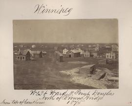
Winnipeg, West Ward, Point Douglas north of Browns Bridge, 1875
- i00035
- Item
- 1875
Part of City of Winnipeg (1874-1971)
Photograph taken from top of Courthouse.
Winnipeg, West Ward, Point Douglas north of Browns Bridge, 1875
Part of City of Winnipeg (1874-1971)
Photograph taken from top of Courthouse.
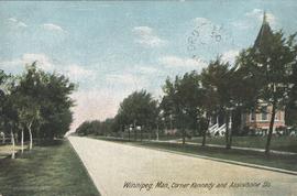
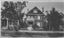
Winnipeg, Man., Corner Kennedy and Assiniboine Sts.
Postcard shows view of Kennedy Street, looking North from Assiniboine Avenue. Nicholas Bawlf residence, 11 Kennedy Street, shown at right foreground. Published by W. J. & Co. Ltd., Toronto, made in Germany. Date of postcard is approximate, ca. 1906.

Winnipeg, Main Street looking south, Summer 1875
Part of City of Winnipeg (1874-1971)
Photograph taken from top of Courthouse.

Winnipeg, Main Street looking south, Spring of 1874
Part of City of Winnipeg (1874-1971)
Photograph taken from top of Courthouse.
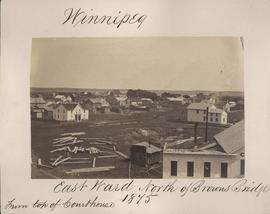
Winnipeg, East Ward, north of Browns Bridge, 1875
Part of City of Winnipeg (1874-1971)
Photograph taken from top of Courthouse.
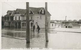
Winnipeg under water - April 1916
Postcard is a photographic print showing water flooding homes likely in St. Boniface. Unknown photographer, Noko mark appears in stamp box.


Wildwood Park - Three weeks before flood, 1950

Wildwood Park - Three weeks before flood, 1950
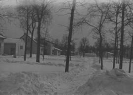
Wildwood Park - Three weeks before flood, 1950
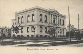
View of Carnegie Library, 380 William Avenue
Shown in background (left) is Francis Cornish residence, in background (right) Victoria School is visible. Date of postcard is approximate, ca. 1905.

Sandbags on the dyke (Wildwood Park - flood, 1950)
![Sandbags - E sec [section] (Wildwood Park - flood, 1950)](/uploads/r/city-of-winnipeg-archives-amp-records-control-branch/c/4/a/c4a7e5ee657f2cf565da1e983d41beae65af0b67f4b9fb5fa71c540b99003de4/C0013_0000_0000_P0022_0094_001_142.jpg)
Sandbags - E sec [section] (Wildwood Park - flood, 1950)


Preliminary Report on Residential Areas - Metropolitan Plan for Greater Winnipeg
Part of City Clerk's Library collection
Item consists of 1 report (60 pages), jointly prepared by the Metropolitan Planning Committee and Winnipeg Town Planning Commission. The report focuses on residential areas in the Greater Winnipeg Area. Part of the Metropolitan Plan for Greater Winnipeg - number 7 of master plan reports.
Manitoba. Metropolitan Planning Commission of Greater Winnipeg
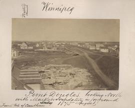
Point Douglas looking north with City Hall foundation in foreground, August 1875
Part of City of Winnipeg (1874-1971)
Photograph taken from top of Courthouse.

Point Douglas from Courthouse, 1874
Part of City of Winnipeg (1874-1971)

Part of East Ward, St. Boniface in the distance
Part of City of Winnipeg (1874-1971)
Photograph taken from top of Courthouse.
Our place - 49 Balmoral Place, Winnipeg, Manitoba
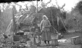
Only station woman on GWWD railway construction
Photograph of the only station woman for the construction of the Greater Winnipeg Water District Railway holding the hand of a child in front of a shelter, possibly near Shoal Lake. Photograph taken by C.J. Bruce, one of the Division Engineers for the Winnipeg Aqueduct.
Greater Winnipeg Water District