
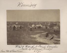
Winnipeg, West Ward, Point Douglas north of Browns Bridge, 1875
- i00035
- Item
- 1875
Part of City of Winnipeg (1874-1971)
Photograph taken from top of Courthouse.
54 results with digital objects Show results with digital objects
Winnipeg, West Ward, Point Douglas north of Browns Bridge, 1875
Part of City of Winnipeg (1874-1971)
Photograph taken from top of Courthouse.
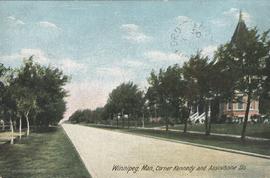
Winnipeg, Man., Corner Kennedy and Assiniboine Sts.
Postcard shows view of Kennedy Street, looking North from Assiniboine Avenue. Nicholas Bawlf residence, 11 Kennedy Street, shown at right foreground. Published by W. J. & Co. Ltd., Toronto, made in Germany. Date of postcard is approximate, ca. 1906.

Winnipeg, Main Street looking south, Summer 1875
Part of City of Winnipeg (1874-1971)
Photograph taken from top of Courthouse.

Winnipeg, Main Street looking south, Spring of 1874
Part of City of Winnipeg (1874-1971)
Photograph taken from top of Courthouse.
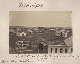
Winnipeg, East Ward, north of Browns Bridge, 1875
Part of City of Winnipeg (1874-1971)
Photograph taken from top of Courthouse.
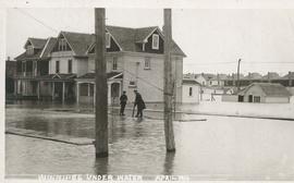
Winnipeg under water - April 1916
Postcard is a photographic print showing water flooding homes likely in St. Boniface. Unknown photographer, Noko mark appears in stamp box.


Wildwood Park - Three weeks before flood, 1950

Wildwood Park - Three weeks before flood, 1950
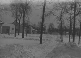
Wildwood Park - Three weeks before flood, 1950
Part of City of Winnipeg (1874-1971)
A photograph taken during the 1950 flood, showing Wellington by Maryland Bridge. Item is 1 of 8 photographs on page 90 of scrapbook.
Harold K. White Studio
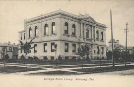
View of Carnegie Library, 380 William Avenue
Shown in background (left) is Francis Cornish residence, in background (right) Victoria School is visible. Date of postcard is approximate, ca. 1905.
Under construction, Oakwood Street
Part of City of Winnipeg (1874-1971)
A photograph taken during the 1950 flood, showing Oakwood Street under construction. Item is 1 of 7 photographs on page 25 of scrapbook.
Harold K. White Studio
S.W. Corner Arnold & Mabel (62?)
Part of City of Winnipeg (1874-1971)
A photograph taken during the 1950 flood, showing the southwest corner of Arnold Avenue and Mabel Avenue and possibly 62 Arnold Avenue. Item is 8 of 8 photographs on page 1 of scrapbook.
Harold K. White Studio
An album page with a photograph on each side. The photographs depict a Parks Board supervised skating rink outside the Northland Knitting Company at 618 Arlington Street on each side.
S.E. Corner Arnold Avenue (100 Arnold?)
Part of City of Winnipeg (1874-1971)
A photograph taken during the 1950 flood, showing the southeast corner of Arnold Avenue and possibly 100 Arnold Avenue. Item is 7 of 8 photographs on page 1 of scrapbook.
Harold K. White Studio
Four photographs affixed two to each side of a page of construction paper. The two photos on the first side depict children playing at the Scotia Rink, while those on the second depict children on a swing set and eating ice cream.
Part of City of Winnipeg (1874-1971)
A photograph taken during the 1950 flood, showing "Scotia Block" on Scotia Street. Item is 2 of 8 photographs on page 46 of scrapbook.
Harold K. White Studio

Sandbags on the dyke (Wildwood Park - flood, 1950)
![Sandbags - E sec [section] (Wildwood Park - flood, 1950)](/uploads/r/city-of-winnipeg-archives-amp-records-control-branch/c/4/a/c4a7e5ee657f2cf565da1e983d41beae65af0b67f4b9fb5fa71c540b99003de4/C0013_0000_0000_P0022_0094_001_142.jpg)
Sandbags - E sec [section] (Wildwood Park - flood, 1950)