Showing 105 results

archival descriptions
Item Commercial buildings Image With digital objects
Print preview Hierarchy View:

Portage and Main, looking west down Portage Avenue

Photograph of Portage Avenue looking west from the intersection at Main Street. Various shops and business are featured in buildings at Portage and Main that no longer exist, including the towering McArthur/Child's Building on the right. Photograph by Henry Kalen.

Metropolitan Corporation of Greater Winnipeg (Man.). Information Officer

City Hall and courtyard, facing Market Avenue

Photograph of the front side of Winnipeg's second City Hall, facing towards Market Avenue. Also featured in the photograph is the green space in front of City Hall, the Jubilee Fountain, the Volunteer Monument, businesses and store fronts on Market Avenue, and the McLaren and Cornwall Hotels in the distance. Photographed by Henry Kalen.

Metropolitan Corporation of Greater Winnipeg (Man.). Information Officer

Winnipeg Renovating Co

Photograph of the Winnipeg Renovating Co. on Lombard Avenue. Item is part of small album containing photographs of maps tracking the outbreak of typhoid from 1905 to 1908 and other scenes. Item is loose and at back of album. Date of item is approximate, [circa 1909].

Winnipeg Renovating Co

Photograph of the Winnipeg Renovating Co. and the Grain Exchange on Lombard Avenue. Item is part of small album containing photographs of maps tracking the outbreak of typhoid from 1905 to 1908 and other scenes. Item is loose and at back of album. Date of item is approximate, [circa 1909].

North side of Lombard, Rorie to Main Street

A photograph of storefronts and advertisements on the north side of Lombard Avenue, between Rorie Street and Main Street. The photograph is part of small album containing photographs of maps tracking the outbreak of typhoid from 1905 to 1909 and other scenes. Item is loose and at back of album.

North End Farmers' Market

Photograph shows the North End Farmer's Market, looking east across Main Street (northwest Main Street and Stella Avenue). Included in photograph: stalls filled with vegetables and people walking through the market, Aime Bicycle Shop, 909 Main Street, two-storey brick building (899-905 Main Street), and Norquay School.

North End Farmers' Market

Photograph shows the North End Farmer's Market (west side Main Street, north of Stella Avenue, looking west to King Street). Included in photograph: front entrance to market, automobiles parked on street, and North End Horse Exchange (523 King Street). Photograph likely taken from 919-921 Main Street by city employee.

Polo Park Shopping Centre panorama

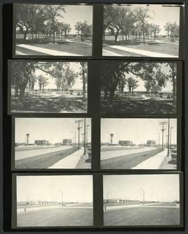
View of Polo Park Shopping Centre, 1485 Portage Avenue, 41 acres. East side of shopping centre. From left to right: the Pancake House, Simpsons-Sears, Perth's Dry Cleaners, Genser's Furniture, Daytons, Jack and Jill, Reward, Gordi's Restaurant, Ricki’s, addition to shopping centre under construction, Dominion Store, CJAY-TV Station (CKY-TV), Winnipeg Arena. Consists of 4 separate photographs pasted together on cardboard to create a panorama. The cardboard is a scrap made from an old sign of the Metropolitan Corporation of Greater Winnipeg (visible on the reverse). The cardboard is numbered “12”, presumably as part of a compilation with other shopping centre panoramas.

Metropolitan Corporation of Greater Winnipeg (Man.). Planning Division

Polo Park Shopping Centre panorama

View of Polo Park Shopping Centre, 1485 Portage Avenue, 41 acres. West side of shopping centre, north side of Portage Avenue between Empress Street and St. James Street. Left to Right: Winnipeg Stadium, Winnipeg Arena, Loblaws, Simpson Sears Marina, Simpson Sears Garden Shop, Simpson Sears Department Store, Simpson Sears Service Station. Consists of 4 separate photographs pasted together on cardboard to create a panorama. The cardboard is a scrap made from an old sign of the Metropolitan Corporation of Greater Winnipeg (visible on the reverse). The cardboard is numbered “11”, presumably as part of a compilation with other shopping centre panoramas.

Metropolitan Corporation of Greater Winnipeg (Man.). Planning Division

Northgate Shopping Centre panorama

View of Northgate Plaza Shopping Centre, 1375-1425 McPhillips Street, 15 acres. From left to right: Clarks Discount Store, Various Shops, Northgate Bowling Lanes, Loblaw's. Consists of 3 separate photographs pasted together on cardboard to create a panorama. The cardboard is a scrap made from an old sign of the Metropolitan Corporation of Greater Winnipeg (visible on the reverse). The cardboard is numbered “14”, presumably as part of a compilation with other shopping centre panoramas.

Metropolitan Corporation of Greater Winnipeg (Man.). Planning Division

Polo Park Shopping Centre panorama

View of Polo Park Shopping Centre, 1485 Portage Avenue, 41 acres. South side of shopping centre. Left to right: Winnipeg Motor Products, Motor Club, Simpson Sears Service Station, Simpson Sears Department Store. Consists of 3 separate photographs pasted together on cardboard to create a panorama. The cardboard is a scrap made from an old sign of the Metropolitan Corporation of Greater Winnipeg (visible on the reverse). The cardboard is numbered “13”, presumably as part of a compilation with other shopping centre panoramas.

Metropolitan Corporation of Greater Winnipeg (Man.). Planning Division

Westwood Shopping Centre panorama

View of Westwood Shopping Centre, 3276-3332 Portage Avenue, 10.2 acres. From left to right: various shops, motel, various shops and Assiniboia Public Library, Safeway Store, Marshall Wells, Perths, Westwood Pharmacy, various Shops, Zeller's County Fair, Auto Centre. Consists of 3 separate photographs pasted together on cardboard to create a panorama. The cardboard is a scrap made from an old sign of the Metropolitan Corporation of Greater Winnipeg (visible on the reverse). The cardboard is numbered “10”, presumably as part of a compilation with other shopping centre panoramas.

Metropolitan Corporation of Greater Winnipeg (Man.). Planning Division

Crestview Shopping Centre panorama

View of Crestview Shopping Centre, 3395 Portage Avenue, 8.3 acres. From left to right: Kmart Department Store, Dominion Store, Various Shops. Consists of 3 separate photographs pasted together on cardboard to create a panorama. The cardboard is a scrap made from an old sign of the Metropolitan Corporation of Greater Winnipeg (visible on the reverse). The cardboard is numbered “9”, presumably as part of a compilation with other shopping centre panoramas.

Metropolitan Corporation of Greater Winnipeg (Man.). Planning Division

Grant Plaza Shopping Centre panorama

View of Grant Park Plaza Shopping Centre, 1200-1216 Grant Avenue, 13.2 acres. From left to right: Clarks Discount Store, Dominion Store, Liquor Commission, Clarks Auto Centre. Consists of 3 separate photographs pasted together on cardboard to create a panorama. The cardboard is a scrap made from an old sign of the Metropolitan Corporation of Greater Winnipeg (visible on the reverse). The cardboard is numbered “8”, presumably as part of a compilation with other shopping centre panoramas.

Metropolitan Corporation of Greater Winnipeg (Man.). Planning Division

Southgate Shopping Centre panorama

View of Southgate Village Shopping Centre, 1305-1341 Pembina Highway at the southwest corner of McGillivray Boulevard, 3.3 acres. From left to right: Pembina Curling Rink, Imperial Cleaners, Safeway, The Place, Young Togs, Reid Marshall Pharmacy, The Village Gift Shop, The French Salon, Marshall Wells, The Toronto Dominion Bank, Safeway gas bar. Consists of 3 separate photographs pasted together on cardboard to create a panorama. The cardboard is a scrap made from an old sign of the Metropolitan Corporation of Greater Winnipeg (visible on the reverse). The cardboard is numbered “7”, presumably as part of a compilation with other shopping centre panoramas.

Metropolitan Corporation of Greater Winnipeg (Man.). Planning Division

Dakota Village Shopping Centre panorama

View of Dakota Village Shopping Centre, 1077-1095 St. Mary's Road, 3.5 acres. From left to right: unknown stores, Ladies and Children's Wear, Lance Pharmacy, [Dakota?] Bowling, Shoe Fair, Bank of Nova Scotia, Safeway, apartment block, Bank of Montreal. Consists of 3 separate photographs pasted together on cardboard to create a panorama. The cardboard is a scrap made from an old sign of the Metropolitan Corporation of Greater Winnipeg (visible on the reverse). The cardboard is numbered “6”, presumably as part of a compilation with other shopping centre panoramas.

Metropolitan Corporation of Greater Winnipeg (Man.). Planning Division

Results 1 to 20 of 105