

- i01471
- Item
- [after 1932]
Photograph shows old St. James Bridge approach, looking north up Madison Street (now Century Street/Route 90). Present Viscount Gort site in center. Date of photograph is uncertain, [after 1932].
4 results with digital objects Show results with digital objects
Photograph shows old St. James Bridge approach, looking north up Madison Street (now Century Street/Route 90). Present Viscount Gort site in center. Date of photograph is uncertain, [after 1932].

Photograph shows old St. James Bridge approach, looking North up present Kintrye Street. Viscount Gort site centre right/Hydro sub-station - St. James Street and Portage Avenue far left. Date of photograph is uncertain [after 1932].

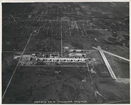
Aerial view of Stevenson Field (Winnipeg Airport)
Inscription (on recto): NE WG F24 AP117 45:55N 97.14W Stevenson Field 27-9-43 15:55 8" 6000'.
Aerial view of Stevenson Field looking South (Winnipeg Airport)
Inscription (on recto): 5A0S AP13 6-6-42 Stevenson Field looking South.