
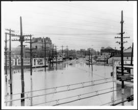
Main Street looking south from Main Street Bridge
- i00142
- Pièce
- 1950
Fait partie de City of Winnipeg (1874-1971)
A photograph of flooded Main Street, looking south from the Main Street Bridge, during the 1950 flood in Winnipeg.
Sans titre
8 résultats avec objets numériques Afficher les résultats avec des objets numériques
Main Street looking south from Main Street Bridge
Fait partie de City of Winnipeg (1874-1971)
A photograph of flooded Main Street, looking south from the Main Street Bridge, during the 1950 flood in Winnipeg.
Sans titre

Fait partie de City of Winnipeg (1874-1971)
A photograph of floodwater and sandbag dikes outside 368 and 372 Main Street during the 1950 flood in Winnipeg.
Sans titre

Fait partie de City of Winnipeg (1874-1971)
A photograph of the intersection of Broadway and Osborne Street during the 1950 flood in Winnipeg. The photo is taken from Osborne Street, looking north; the stone cross of All Saints' Church can be seen near the left side of the image.
Sans titre

Pumping water on Robert Street
Fait partie de City of Winnipeg (1874-1971)
A photograph of a pipe pouring water onto tracks on Robert Street (Galt Avenue) during the 1950 flood. A pile of wood is along one side of the street. The Ogilvie Flour Mill can be seen in the background.
Sans titre
Fait partie de City of Winnipeg (1874-1971)
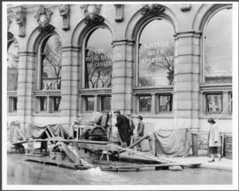
A photograph of floodwater and a pump outside the Royal Bank on Main Street during the 1950 flood in Winnipeg.
Sans titre
Fait partie de City of Winnipeg (1874-1971)
A photograph of the Main Street Bridge during the 1950 flood in Winnipeg. The Hotel Fort Garry can be seen in the background.
Sans titre

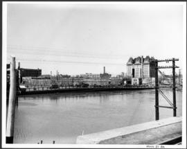
Building Water Street causeway about 2nd day
Fait partie de City of Winnipeg (1874-1971)
A photograph of the building of the Water Street causeway during the 1950 flood in Winnipeg. St. Boniface Cathedral can be seen in the background.
Sans titre
Scrapbook [1950 flood photographs]
Fait partie de City of Winnipeg (1874-1971)
Subseries consists of a scrapbook assembled by the City Engineering Department to serve as photographic evidence of the 1950 flood. It contains black and white photographs that mostly document flooding in residential areas near the Red River (Fort Rouge, Riverview, North End, Point Douglas, Crescentwood, Armstrong's Point and others). Scrapbook appears to be organized geographically by area and street. In addition to documenting flooding, the photographs provide a detailed record of residential neighbourhoods, houses, streets, and businesses like corner grocery stores and laundries. All photographs were taken by Harold K. White Studio.
Sans titre
Fait partie de City of Winnipeg (1874-1971)
A photograph taken during the 1950 flood, showing 46 Notre Dame East. Item is 2 of 6 photographs on page 55 of scrapbook.
Sans titre
Fait partie de City of Winnipeg (1874-1971)
A photograph taken during the 1950 flood, showing 30 Notre Dame East. Item is 1 of 6 photographs on page 55 of scrapbook.
Sans titre
Fait partie de City of Winnipeg (1874-1971)
A photograph taken during the 1950 flood, showing 103 Notre Dame East. Item is 4 of 6 photographs on page 55 of scrapbook.
Sans titre
Fait partie de City of Winnipeg (1874-1971)
A photograph taken during the 1950 flood, showing 134 Notre Dame East. Item is 3 of 6 photographs on page 55 of scrapbook.
Sans titre
Fait partie de City of Winnipeg (1874-1971)
A photograph taken during the 1950 flood, showing 81 Notre Dame East. Item is 5 of 6 photographs on page 55 of scrapbook.
Sans titre
Fait partie de City of Winnipeg (1874-1971)
A photograph taken during the 1950 flood, showing 69 Water Street. Item is 2 of 3 photographs on page 56 of scrapbook.
Sans titre
Fait partie de City of Winnipeg (1874-1971)
A photograph taken during the 1950 flood, showing 155 Water Street. Item is 3 of 3 photographs on page 56 of scrapbook.
Sans titre
Fait partie de City of Winnipeg (1874-1971)
A photograph taken during the 1950 flood, showing 115 Notre Dame East. Item is 6 of 6 photographs on page 55 of scrapbook.
Sans titre
Fait partie de City of Winnipeg (1874-1971)
A photograph taken during the 1950 flood, showing 43 Water Street. Item is 1 of 3 photographs on page 56 of scrapbook.
Sans titre
Fait partie de City of Winnipeg (1874-1971)
A photograph taken during the 1950 flood, showing 372 Assiniboine Avenue. Item is 1 of 8 photographs on page 79 of scrapbook.
Sans titre
356 and 358 Assiniboine Avenue
Fait partie de City of Winnipeg (1874-1971)
A photograph taken during the 1950 flood, showing 356 Assiniboine Avenue and 358 Assiniboine Avenue. Item is 4 of 8 photographs on page 79 of scrapbook.
Sans titre
296 and 300 Assiniboine Avenue
Fait partie de City of Winnipeg (1874-1971)
A photograph taken during the 1950 flood, showing 296 Assiniboine Avenue and 300 Assiniboine Avenue. Item is 7 of 8 photographs on page 79 of scrapbook.
Sans titre