

Crane and David, Bakers and Confectioners
- i01411
- Item
- [ca. 1910]
Staff standing in front of Crane and David Bakers and Confectioners at 765 Dufferin Avenue and a horse-drawn delivery cart.
123 results with digital objects Show results with digital objects
Crane and David, Bakers and Confectioners
Staff standing in front of Crane and David Bakers and Confectioners at 765 Dufferin Avenue and a horse-drawn delivery cart.
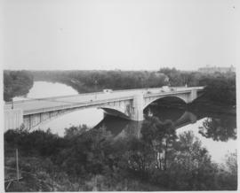
Photograph shows Maryland Street Bridge looking southeast into Crescentwood. Date of photograph is approximate, ca. 1925.

Photograph shows old St. James Bridge approach, looking north up Madison Street (now Century Street/Route 90). Present Viscount Gort site in center. Date of photograph is uncertain, [after 1932].
Entrance to Winnipeg and Parliament Buildings
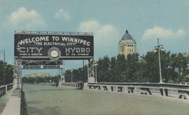
Postcard shows Osborne Street bridge, looking north. Sign over bridge says, "Welcome to Winnipeg, The Electrical City. City Hydro, Owned and Operated by its Citizens". Date of postcard is approximate, ca. 1940.
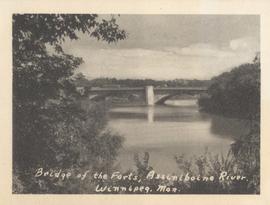
Bridge of the Forts, Assiniboine River, Winnipeg, Man.
Date of photograph is approximate, ca. 1940.
VE Day in Winnipeg showing Portage Avenue and Eaton's building in background
Photograph shows Victory in Europe Day (VE Day) celebrations marking the end of World War 2 in Europe.

Scrapbook of Corporal Wallace – page 9
Page 9 of a photograph scrapbook made by Corporal John Wallace in April 1940. Photographs depict a street in Gladstone Manitoba, a trolley bus in Winnipeg on Kennedy Street (between Ellice and Qu'Appelle), and the Butler family, acquaintances of Wallace. See page three of this scrapbook for more details on the Butler family.
Wallace, John

1932 Relief Works and Committee Winnipeg
Photograph collage of the 1932 Winnipeg Relief Works and Committee. Portraits of committee members are surrounding photographs of projects the committee had worked on. The committee members are, clockwise from top left: Alderman John Blumberg, Alderman H. Andrews, City Clerk Magnus Peterson, Alderman J.A. Barry, Alderman A.A. Ryley, Alderman W.B. Simpson, City Engineer W.P. Brereton, G.W. Northwood, Alderman E.D. Honeyman, Mayor Ralph Webb, Alderman J.A. McKerschar, A. MacNamara, Resident Engineer A.J. Taunton, Alderman L.F. Borrowman, and Alderman C.E. Simonite. The works projects showcased in the center are, clockwise from top left: the Main Street Bridge, the Norwood Bridge, the Assiniboine Park Bridge, the Winnipeg Auditorium, the Sargent Park Swimming Pool, and the Salter Street Bridge. Created by Robson Photo.

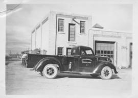
Delivery Truck, Lake of the Woods Milling Company
A delivery truck belonging to the Lake of the Woods Milling Company (later known as Five Roses Flour and merged with the Ogilvie Milling Company in 1954), which was based in Keewatin, Ontario.
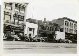
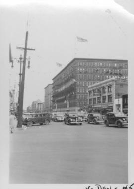
Storefronts on Portage Avenue between Carlton and Hargrave Streets
Cars and shoppers in front of stores on the north side of Portage Avenue, between Carlton and Hargrave Streets. Featured are The Berryhill Shoe Store in the Enderton / Mitchell-Copp Building, the Bank of Montreal, Zeller's (Zellers), and Rannards Shoes in

Portage Avenue looking west from Colony Street
A view of Portage Avenue looking west from Colony Street. The Hudson's Bay Company Building is featured prominantly and the Power Building and the Boyd Building are visible farther west.

Dakota Village Shopping Centre panorama
View of Dakota Village Shopping Centre, 1077-1095 St. Mary's Road, 3.5 acres. From left to right: unknown stores, Ladies and Children's Wear, Lance Pharmacy, [Dakota?] Bowling, Shoe Fair, Bank of Nova Scotia, Safeway, apartment block, Bank of Montreal. Consists of 3 separate photographs pasted together on cardboard to create a panorama. The cardboard is a scrap made from an old sign of the Metropolitan Corporation of Greater Winnipeg (visible on the reverse). The cardboard is numbered “6”, presumably as part of a compilation with other shopping centre panoramas.
Metropolitan Corporation of Greater Winnipeg (Man.). Planning Division

Thoroughfares: Academy Road at Wellington Crescent
View of cars and cyclists heading down Academy Road towards Wellington Crescent and the Maryland Bridge. The cupola of Misericordia Hospital can be seen across the bridge.

Aerial of 1974 Flood – Pritchard Avenue Boat Dock and Redwood Bridge
Aerial photograph of the Red River during the 1974 Flood. The photograph faces northwest towards the North End, with the Pritchard Avenue Boat Dock in the bottom left and the Redwood Bridge in the top right. The photographs were taken by the Department of Environmental Planning.
Winnipeg (Man.). Department of Environmental Planning

Winnipeg’s Best Tourist Cabin Camp on Pembina Highway
Postcard featuring “Winnipeg’s Best Tourist Cabin Camp”, located on Pembina Highway (then Highway Number 14) around Chevrier Boulevard.

Winnipeg Tourist Cabins and Camp Park on Pembina Highway
Postcard featuring “Winnipeg Tourist Cabins and Camp Park”, located on Pembina Highway (then Highway Number 14) around Chevrier Boulevard.
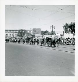
Winnipeg's 75th Anniversary parade - riders on horseback
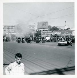
Winnipeg's 75th Anniversary parade - men on motorcycles
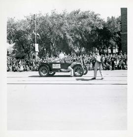
Winnipeg's 75th Anniversary parade - G. Meech 1912 Hupmobile float