

Thoroughfares: Academy Road at Wellington Crescent
- i04019
- Item
- [194-?]
View of cars and cyclists heading down Academy Road towards Wellington Crescent and the Maryland Bridge. The cupola of Misericordia Hospital can be seen across the bridge.
11 results with digital objects Show results with digital objects
Thoroughfares: Academy Road at Wellington Crescent
View of cars and cyclists heading down Academy Road towards Wellington Crescent and the Maryland Bridge. The cupola of Misericordia Hospital can be seen across the bridge.

Thoroughfares: Academy Road at Wellington Crescent
View of cars and cyclists heading down Academy Road towards Wellington Crescent and the Maryland Bridge. A small portion of Misericordia Hospital can be seen across the bridge.

Scrapbook of Corporal Wallace – page 9
Page 9 of a photograph scrapbook made by Corporal John Wallace in April 1940. Photographs depict a street in Gladstone Manitoba, a trolley bus in Winnipeg on Kennedy Street (between Ellice and Qu'Appelle), and the Butler family, acquaintances of Wallace. See page three of this scrapbook for more details on the Butler family.
Wallace, John
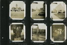
Scrapbook of Corporal Wallace – page 6
Page 6 of a photograph scrapbook made by Corporal John Wallace in April 1940. Photographs depict the Pavilion in City Park (Assiniboine Park), the Legislature Building off in the distance down Memorial Boulevard, St. Ignatius Church at Corydon Avenue and Stafford Street, the Winnipeg Cenotaph, and acquaintenances of Wallace, Mr. and Mrs. McCarthy and “Sister Sue”, and two people identified only as “Joan” and “Den”. See general notes section for more details.
Wallace, John
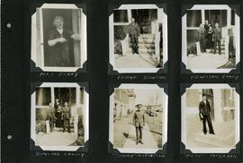
Scrapbook of Corporal Wallace – page 5
Page 5 of a photograph scrapbook made by Corporal John Wallace in April 1940. Photographs depict several acquaintenance of Wallace including two fellow soldiers, “Sonny” Robertson and Joseph “Fuss” McGrath, a Mrs. Penny, and a Frank Dowling and his family. See the general notes section for more details.
Wallace, John
![Legislative Building and Central Winnipeg [Aerial view]](/uploads/r/city-of-winnipeg-archives-amp-records-control-branch/5/1/1/511af88a9e92fe7d7d3edda2bdaee6fc5652013532efb88411d3403dfcf85917/C0013_0000_0000_P0018_0046_001_142.jpg)
Legislative Building and Central Winnipeg [Aerial view]
Inscription (on recto): WG M35: 4-5, 5 Mar '45, Legislative Bldg and Central Wpg, appr. scale 1/12000.

Grant Plaza Shopping Centre panorama
View of Grant Park Plaza Shopping Centre, 1200-1216 Grant Avenue, 13.2 acres. From left to right: Clarks Discount Store, Dominion Store, Liquor Commission, Clarks Auto Centre. Consists of 3 separate photographs pasted together on cardboard to create a panorama. The cardboard is a scrap made from an old sign of the Metropolitan Corporation of Greater Winnipeg (visible on the reverse). The cardboard is numbered “8”, presumably as part of a compilation with other shopping centre panoramas.
Metropolitan Corporation of Greater Winnipeg (Man.). Planning Division
![CNR Yards [Aerial view]](/uploads/r/city-of-winnipeg-archives-amp-records-control-branch/3/a/c/3acce1afab65125da800d4ce81f386345349a1e9b9021d949ebfd6c8147f2db0/C0013_0000_0000_P0018_0044_001_142.jpg)
Inscription (on recto): WG M35: 3-8, 5 Mar '45, CNR Yards Wpg, appr scale 1/12000.
![CNR Yards [Aerial view]](/uploads/r/city-of-winnipeg-archives-amp-records-control-branch/e/1/8/e184dce7e98d8a8fabf3b8481cfbdc63ba39898edb5f89746bd2e0a6795f8148/C0013_0000_0000_P0018_0045_001_142.jpg)

Aerial view of Riverview, St. Vital, and Wildwood
Aerial view of the Riverview area of Fort Rouge, including Osborne Street; the Wildwood area of Fort Garry; and the Kingston Crescent, Elm Park, Varennes, St. George, and Glenlawn areas of St. Vital, including Kingston Row, St. Mary’s Road, and St. Anne’s Road.

Aerial photograph south of Winnipeg, east of Red River, 1943
Photograph shows an aerial view of south of Winnipeg, east of Red River. Photograph dated December 2, 1943.